In partnership with: 
|
January 17, 2012 at 7:51 am |
|
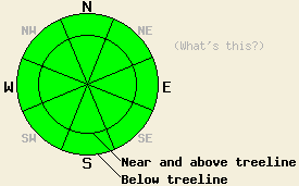
Avalanche danger remains LOW for all elevations and aspects. Normal caution is advised. A period of increased avalanche danger is anticipated for the second half of this week. |
|
|
|
Transitional weather will occur today with increasing cloud cover and increasing southwest winds ahead of the much anticipated series of storms that are moving towards the forecast area. Air temperatures this morning are in the teens and single digits across the forecast area. This cold start to the day will limit daytime warming with high temperatures in the 20s and 30s expected for nearly all elevations. Ridgetop winds remain light to moderate in speed out of the southwest this morning. Moderate to strong wind speeds are forecast to occur by this afternoon. Southwest winds are expected to steadily increase tonight into tomorrow, eventually becoming gale force. Precipitation is expected to reach the forecast area around mid day tomorrow with an inch of two of new snow accumulation possible at the mid and upper elevations by the evening hours.
For the existing snowpack, the general theme remains surface crust overlying varying amounts of faceted snow. Areas along the Sierra Crest in the northern half to third of the forecast area hold the deepest snowpack. Elsewhere, significantly less snow exists. The warming and rain event that occurred on December 28-29 added either a rain crust or melt freeze crust to the snow surface in nearly all areas on NW-N-NE-E aspects. Since that time, faceting has continued below this crust and within other layers of the snowpack. Sufficient time has passed to allow for significant weakening of the faceted snow directly below the surface crust. Areas where the snowpack remains in a strong melt-freeze state from top to bottom still exist, but are becoming increasingly isolated. This is mainly seen in areas of hold over snow from last winter and in a few spots that have not undergone significant faceting since the Dec 28-29 event. SE-S-SW-W aspects are generally void of snow except for a few shallow patches in heavily shaded areas.
Avalanche Concerns:
Despite the increasing presence of weak faceted snow in many areas, avalanche activity will remain unlikely until precipitation reaches the forecast area. In the areas with the deepest snowpack, very strong and supportable surface crusts are keeping the faceted snow below from collapsing when loaded. In areas where the crust is breakable, it is too brittle to sustain propagation. In areas where less snow exists, significant anchors are holding the snowpack in place. The right combination of slab, weak layer, and bed surface necessary for slab avalanche activity has not been observed within the forecast area at this time. This will change and increased avalanche danger is expected to occur later this week as storm systems bring a new load to the snowpack. The half inch of new snow that was deposited late Saturday in some spots in the northern half of the forecast area has been subject to cold temperatures while sitting on top of a crust. Concerns exist for this to form a thin faceted layer directly on top and the crust. This will be something to watch and see if it is buried under storm slabs in the coming days.
Avalanche danger remains LOW for all elevations and aspects. Normal caution is advised. A period of increased avalanche danger is anticipated for the second half of this week.
| 0600 temperature: | 9 to 19 deg. F. |
| Max. temperature in the last 24 hours: | 14 to 25 deg. F. |
| Average wind direction during the last 24 hours: | Southwest |
| Average wind speed during the last 24 hours: | 24 mph |
| Maximum wind gust in the last 24 hours: | 35 mph |
| New snowfall in the last 24 hours: | O inches |
| Total snow depth: | 0 to 18 inches |
For 7000-8000 ft: |
|||
| Tuesday: | Tuesday Night: | Wednesday: | |
| Weather: | Sunny skies in the morning, becoming partly cloudy. | Mostly cloudy skies. | Cloudy skies with a chance of snow. |
| Temperatures: | 23 to 30 deg. F. | 14 to 21 deg. F. | 31 to 38 deg. F. |
| Wind direction: | SW | SW | SW |
| Wind speed: | 15 to 20 mph with gusts to 30 mph. | 15 to 25 mph with gusts to 35 mph. | 20 to 30 mph with gusts to 45 mph. |
| Expected snowfall: | O in. | O in. | Near the Sierra Crest, locally up to 1 in. |
For 8000-9000 ft: |
|||
| Tuesday: | Tuesday Night: | Wednesday: | |
| Weather: | Sunny skies in the morning, becoming partly cloudy. | Mostly cloudy skies. | Cloudy skies with a chance of snow. |
| Temperatures: | 26 to 32 deg. F. | 14 to 21 deg. F. | 25 to 32 deg. F. |
| Wind direction: | SW | SW | SW |
| Wind speed: | 25 to 35 mph with gusts to 55 mph. | 30 to 40 mph with gusts to 60 mph. | 40 to 45 mph with gusts to 70 mph, increasing to 50 to 65 mph with gusts to 95 mph in the afternoon. |
| Expected snowfall: | O in. | O in. | Near the Sierra Crest, locally up to 2 in. |


This website is owned and maintained by the non-profit arm of the Sierra Avalanche Center. Some of the content is updated by the USDA avalanche forecasters including the forecasts and some observational data. The USDA is not responsible for any advertising, fund-raising events/information, or sponsorship information, or other content not related to the forecasts and the data pertaining to the forecasts.

