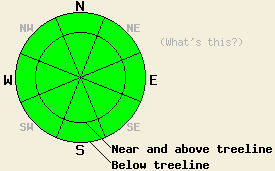
This Avalanche Advisory was published on February 1, 2012:

|
February 1, 2012 at 7:59 am |
|
The avalanche danger remains LOW for all elevations and aspects. Continue to use normal caution traveling in the backcountry. |
|
|
|
Forecast Discussion:
The winds and clouds started to increase yesterday afternoon as the low pressure system gained strength and surprisingly changed paths to pass more directly over the forecast area. This storm brought one to two inches of new snow to the forecast area north of Carson Pass early this morning. Snow showers and strong southwest winds should continue this morning before decreasing this afternoon. As this system moves out of the area tonight, the skies should begin to clear up and the winds should shift to the north and east due to a strong high pressure ridge building behind this storm. The forecast calls for mostly sunny skies with daytime highs in the mid 30's across the region by tomorrow. The strong northeast winds should also begin to decrease some tomorrow afternoon and evening.
Yesterday, observations on Tallac Peak (photos - more info), on Mt. Judah (photos - more info), and on Castle Peak (photos - more info) all showed similar conditions to those seen across the forecast area this week. Melt-freeze conditions existed on the sun-exposed SE-S-SW aspects with one to three inches of soft, wet snow forming on top of a strong supportable snowpack by midday. On Castle Peak some older wet loose snow slides existed. Observers found no new signs of wet snow instability in any areas yesterday. On the northerly aspects, widespread breakable crusts with a thin layer of softer weaker snow (facets) below them comprised the upper portion of the snowpack. Observations did not reveal any slab layers on top of this crust/facet combination. Underneath this thin layer of facets a well bonded and strong snowpack remains.
Avalanche Concerns:
Avalanche activity should remain unlikely again today since the additional one to two inches of new snow should not add enough weight to the snowpack to overload and break the crust/facet combination on the northerly aspects. A few small shallow wind slabs may form on the N-NE-E aspects near and above treeline today due to wind loading. Even though these shallow slabs may produce minor cracking, they should not grow large enough to pose a major threat to backcountry travelers unless more snow falls than forecasted. Colder weather and no sun exposure should allow the southerly aspects to continue refreezing thus preventing instabilities on those slopes. Icy slopes with a dusting of new snow, exposed rocks and trees, cliffs, and other terrain traps remain the most problematic backcountry hazards due to their ability to magnify the consequences of even the smallest snow slides or falls.
The bottom line:
The avalanche danger remains LOW for all elevations and aspects. Continue to use normal caution traveling in the backcountry.
Weather Observations from along the Sierra Crest between 8200 ft and 8800 ft:
| 0600 temperature: | 21-27 deg. F. |
| Max. temperature in the last 24 hours: | 39-46 deg. F. |
| Average wind direction during the last 24 hours: | Southwest |
| Average wind speed during the last 24 hours: | Along the Sierra Crest: 25 mph | In the Mt Rose area: 35 mph |
| Maximum wind gust in the last 24 hours: | Along the Sierra Crest: 51 mph | In the Mt Rose area: 77 mph |
| New snowfall in the last 24 hours: | 1-2 inches |
| Total snow depth: | 19-38 inches |
Two-Day Mountain Weather Forecast - Produced in partnership with the Reno NWS
For 7000-8000 ft: |
|||
| Wednesday: | Wednesday Night: | Thursday: | |
| Weather: | Widespread snow showers in the morning becoming mostly cloudy with scattered snow showers in the afternoon | Partly cloudy | Partly cloudy |
| Temperatures: | 30-37 deg. F. | 18-28 deg. F. | 31-38 deg. F. |
| Wind direction: | Southwest | North | Northeast |
| Wind speed: | 15-25 mph with gusts to 40 mph | 20-30 mph with gusts to 35 mph increasing to 45 mph after midnight | 15-25 mph with gusts to 40 mph |
| Expected snowfall: | up to 1 in. | O in. | O in. |
For 8000-9000 ft: |
|||
| Wednesday: | Wednesday Night: | Thursday: | |
| Weather: | Widespread snow showers in the morning becoming mostly cloudy with scattered snow showers in the afternoon | Partly cloudy | Partly cloudy |
| Temperatures: | 26-32 deg. F. | 18-28 deg. F. | 32-35 deg. F. |
| Wind direction: | Southwest | Northwest shifting to the north after midnight | Northeast |
| Wind speed: | 35-45 mph with gusts to 70 mph | 25-30 mph with gusts to 45 mph increasing to 40-45 mph with gusts to 65 mph after midnight | 30-40 mph with gusts to 60 mph decreasing to 50 mph in the afternoon |
| Expected snowfall: | up to 2 in. | O in. | O in. |


