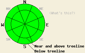
This Avalanche Advisory was published on February 6, 2012:

|
February 6, 2012 at 8:00 am |
|
Avalanche danger remains LOW for all elevations and aspects. Use normal caution when traveling in the backcountry. |
|
|
|
Forecast Discussion:
Cloud cover, winds, and daytime highs should all increase today ahead of a low pressure system expected to impact the forecast area tomorrow. By tonight skies should become mostly cloudy and the winds should shift to the south. As this system arrives tomorrow, it should bring cooler temperatures and some snow showers. Actual snowfall amounts will depend on the actual track of this system, but the current forecast predicts less than one inch of accumulation during the day tomorrow.
Observations from Stevens Peak (pit profile), the Fireplug (Mt Rose backcountry - pit profile, more info), and Mt. Judah (photos, more info) yesterday showed conditions similar to those seen recently at other locations across the forecast area. Breakable crusts with weak snow (facets) underneath them exist on the northerly aspects in all three of these places. Some of the more wind-protected northerly aspects also still have areas where one to two inches of newer snow exists on top of the older rain crust. Below these surface layers, snowpit data shows that faceting has started to progress deeper in the snowpack on Stevens Peak and on the Fireplug; however, the lower layers still remain supportable and mostly well consolidated. Observations have not revealed any slabs on top of the snowpack. On more wind-exposed E-NE-N aspects, E-NE winds have scoured all of the recent snow away leaving the rain crust exposed on these slopes. On the southerly aspects on Mt. Judah and on the Fireplug, melt-freeze conditions existed. Some softening occurred below 7800 ft on Mt. Judah on these aspects. Above 7800 ft on Mt Judah and at all elevations on the Fireplug, the snow surface remained frozen due to cooler temperatures and light easterly winds.
Today's Avalanche Concerns:
Even though a weak layer has started forming near the snow surface on the northerly aspects, today's weather will not create new slabs on top of the current snowpack. Increased winds and increased cloud cover should prevent significant melting from occurring today and should help keep the snow surface cooler. This shortened period of melting combined with the fact that the snowpack has undergone several days of melt-freeze cycles should prevent any meaningful wet snow instabilities from forming today. These things will keep avalanche activity unlikely again today. In the future the weak layer forming on the northerly aspects could become an issue if new snow forms a slab layer on top of it.
The bottom line:
Avalanche danger remains LOW for all elevations and aspects. Use normal caution when traveling in the backcountry.
Weather Observations from along the Sierra Crest between 8200 ft and 8800 ft:
| 0600 temperature: | 24-33 deg. F. |
| Max. temperature in the last 24 hours: | 32-40 deg. F. |
| Average wind direction during the last 24 hours: | East |
| Average wind speed during the last 24 hours: | 15 mph |
| Maximum wind gust in the last 24 hours: | 36 mph |
| New snowfall in the last 24 hours: | O inches |
| Total snow depth: | 19-34 inches |
Two-Day Mountain Weather Forecast - Produced in partnership with the Reno NWS
For 7000-8000 ft: |
|||
| Monday: | Monday Night: | Tuesday: | |
| Weather: | Partly cloudy | Mostly cloudy | Cloudy with a slight chance of snow showers in the morning. The chance of snow showers should increase in the afternoon |
| Temperatures: | 37-43 deg. F. | 25-31 deg. F. | 30-35 deg. F. |
| Wind direction: | Southeast | South | South |
| Wind speed: | 10-15 mph in the afternoon | 15-20 mph with gusts to 35 mph after midnight | 15-20 mph with gusts to 35 mph |
| Expected snowfall: | O in. | O in. | less than half an in. |
For 8000-9000 ft: |
|||
| Monday: | Monday Night: | Tuesday: | |
| Weather: | Partly cloudy | Mostly cloudy | Cloudy with a slight chance of snow showers in the morning. Snow showers becoming likely in the afternoon |
| Temperatures: | 33-40 deg. F. | 22-28 deg. F. | 25-30 deg. F. |
| Wind direction: | Southeast | Southeast shifting to the south after midnight | South |
| Wind speed: | 15-20 mph with gusts to 30 mph in the afternoon | 10-15 mph with gusts to 25 mph increasing to 25-30 mph with gusts to 45 mph after midnight | 20-30 mph with gusts to 45 mph |
| Expected snowfall: | O in. | O in. | up to 1 in. |


