In partnership with: 
|
February 8, 2012 at 7:46 am |
|
Avalanche danger remains LOW for all elevations and aspects. Normal caution is advised. |
|
|
|
The storm system that split and and mostly passed around the forecast area yesterday left behind a trace to 2 inches of new snow. High pressure will build over the region today. Sunny skies and warming air temperatures are expected over the next few days. Remote sensors are reporting air temperatures across the forecast area in the 20s this morning. Air temperatures above 7,000' are forecast to warm into the upper 20s to upper 30s today. Winds remain light out of the southwest this early morning, but are forecast to shift to the northeast and increase to moderate in speed as the morning progresses. Moderate speed winds are expected to continue through tomorrow, shifting from east to west tomorrow afternoon. A few additional degrees of warming are expected on Thursday with maximum daytime air temperatures above 7,000' in the 30s and 40s.
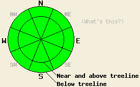
Observations made yesterday on Lincoln Ridge (Yuba Pass area), Tamarack Peak (Mount Rose area), and on Elephant's Back (Carson Pass area) all pointed to the continued trend of a stable snowpack (photos, pit profiles, more info). The lower and middle portions of the snowpack remain strong and well anchored, while near surface faceting continues to weaken the top 1 foot of the snowpack. The surface or near surface rain crust that formed after the January 26 rain event continues become increasingly brittle on northerly aspects. Faceted snow exists below this crust, but no significant slabs exist on top of this crust/facet combo. N-NE-E aspects at and below treeline hold a few inches of soft snow from the February 1 and 7 snowfall events. Above treeline areas had generally been scoured down to the rain crust by NE winds prior to yesterdays snowfall. Well established melt freeze conditions exist on SE-S-SW aspects, with little to no melting occurring on these aspects over the past week.
Today's Avalanche Concerns:
Only minor changes will occur in the snowpack today from what was observed yesterday. As winds shift from SW to NE today, isolated areas of wind transport may be visible over ridgetops in areas that received 1 to 2 inches of new snow yesterday. This redistribution of new snow will not create any significant new wind slabs. Air temperatures will climb above freezing today in some areas, but snow surface melting will be insufficient to create wet snow instabilities on southerly aspects. Many mid and upper elevation SE-S-SW aspects may remain frozen all day. Natural and human triggered avalanche activity remains unlikely today on all aspects and at all elevations.
Avalanche danger remains LOW for all elevations and aspects. Normal caution is advised.
| 0600 temperature: | 23 to 26 deg. F. |
| Max. temperature in the last 24 hours: | 31 to 37 deg. F. |
| Average wind direction during the last 24 hours: | Southwest |
| Average wind speed during the last 24 hours: | 12 mph |
| Maximum wind gust in the last 24 hours: | 22 mph |
| New snowfall in the last 24 hours: | Trace to 2 inches |
| Total snow depth: | 20 to 36 inches |
For 7000-8000 ft: |
|||
| Wednesday: | Wednesday Night: | Thursday: | |
| Weather: | Partly cloudy skies, becoming sunny. | Clear skies. | Sunny skies. |
| Temperatures: | 33 to 40 deg. F. | 23 to 33 deg. F. | 39 to 46 deg. F. |
| Wind direction: | SW shifting to NE | E | E |
| Wind speed: | 10 to 15 mph with gusts to 25 mph in the afternoon. | 10 to 20 mph with gusts to 35 mph. | 5 to 15 mph. |
| Expected snowfall: | O in. | O in. | O in. |
For 8000-9000 ft: |
|||
| Wednesday: | Wednesday Night: | Thursday: | |
| Weather: | Partly cloudy skies, becoming sunny. | Clear skies. | Sunny skies. |
| Temperatures: | 28 to 36 deg. F. | 24 to 30 deg. F. | 33 to 43 deg. F. |
| Wind direction: | SW shifting to NE | E | E shifting to W in the afternoon. |
| Wind speed: | 10 to 15 mph with gusts to 25 mph in the afternoon. | 20 to 30 mph with gusts to 45 mph. | 20 to 25 mph with gusts to 35 mph, shifting and decreasing to 10 to 15 mph with gusts to 25 mph in the afternoon. |
| Expected snowfall: | O in. | O in. | O in. |


This website is owned and maintained by the non-profit arm of the Sierra Avalanche Center. Some of the content is updated by the USDA avalanche forecasters including the forecasts and some observational data. The USDA is not responsible for any advertising, fund-raising events/information, or sponsorship information, or other content not related to the forecasts and the data pertaining to the forecasts.

