In partnership with: 
|
February 11, 2012 at 8:00 am |
|
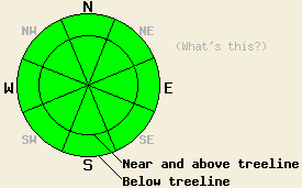
Avalanche danger remains LOW for all elevations and aspects. Use normal caution when traveling in the backcountry. |
|
|
|
Cloud cover and southwest winds increased yesterday as a weak low pressure system moving south from the Pacific Northwest approached the region. This system should pass over the forecast area today and tonight bringing continued cloud cover and a 20-30 % chance of some light snow showers. Snow levels should remain between 5500 and 6000 ft. The forecast calls for little to no accumulation from this system. Snow showers should end tonight and the winds should shift towards the north as the system continues moving south and east out of the area. Cooler air associated with this small storm should keep daytime highs in the high 20's to low 30's in the mountains today and tomorrow with overnight lows in the low 20's tonight. A short-lived small high pressure ridge should rebuild over the region tomorrow before a stronger storm system impacts the area on Sunday night and Monday.
Across the forecast area, observations have shown a mix of breakable crusts that continue to erode, soft weak snow, and wind scoured hard snow on the surface of the northerly aspects. A layer of weak sugary snow known as facets remains just below the surface layers on these aspects. On the sun exposed southerly aspects melt-freeze conditions predominate. On all aspects recent snowpits have shown a strong snowpack exists below the surface layers. Yesterday observations on Jake's Peak and on Relay Peak continued to support these generalizations. On Jake's Peak the process that created the facets near the surface on the northerly aspects showed signs of slowing down and the near surface facets in this area were not as well developed as in other areas (more info - photos). On the sun-exposed southerly aspects in both of these areas, the upper elevation slopes remained mostly frozen with only minor softening occurring while the lower elevation slopes became soft and punchy by the afternoon. On Jake's this change from frozen to soft occurred around 8000 ft, and on Relay Peak it occurred around 9000 ft.
Today's Avalanche Concerns:
Today's cloud cover and cooler daytime temperatures should not allow much melting to occur on the southerly aspects thus preventing wet snow instabilities from forming. Even though a possible weak layer does exist on the northerly aspects in the form of the facets mentioned above, no slab layers reside on top of this weak layer. Today's weather will not form any new slab layers on top of the snowpack. Without a slab layer on top of the weak layer avalanche activity on these aspects will also remain unlikely today.
Avalanche danger remains LOW for all elevations and aspects. Use normal caution when traveling in the backcountry.
| 0600 temperature: | 25-31 deg. F. |
| Max. temperature in the last 24 hours: | 34-43 deg. F. |
| Average wind direction during the last 24 hours: | Southwest |
| Average wind speed during the last 24 hours: | 30-40 mph |
| Maximum wind gust in the last 24 hours: | Along the Sierra Crest: 63 mph | In the Mt Rose area: 87 mph |
| New snowfall in the last 24 hours: | O inches |
| Total snow depth: | 18-33 inches |
For 7000-8000 ft: |
|||
| Saturday: | Saturday Night: | Sunday: | |
| Weather: | Cloudy then becoming mostly cloudy in the afternoon. Some scattered snow showers are possible. | Partly cloudy with isolated snow showers in the evening. | Partly cloudy |
| Temperatures: | 29-36 deg. F. | 21-27 deg. F. | 30-37 deg. F. |
| Wind direction: | Southwest shifting to the west in the afternoon | Northwest | Northwest |
| Wind speed: | 15-20 mph with gusts to 30 mph decreasing to 10-15 mph in the afternoon | 10-15 mph in the evening decreasing during the night | 15-20 mph with gusts to 30 mph |
| Expected snowfall: | Trace to 0 in. | O in. | O in. |
For 8000-9000 ft: |
|||
| Saturday: | Saturday Night: | Sunday: | |
| Weather: | Cloudy then becoming mostly cloudy in the afternoon. Some scattered snow showers are possible. | Partly cloudy with isolated snow showers in the evening. | Partly cloudy |
| Temperatures: | 23-30 deg. F. | 18-24 deg. F. | 30-36 deg. F. |
| Wind direction: | Southwest shifting to the west in the afternoon | North | Northwest |
| Wind speed: | 25-30 mph with gusts to 45 mph decreasing to 10-15 mph in the afternoon | 15-20 mph with gusts to 30 mph in the evening | 15-25 mph with gusts to 35 mph |
| Expected snowfall: | Trace to 0 in. | O in. | O in. |


This website is owned and maintained by the non-profit arm of the Sierra Avalanche Center. Some of the content is updated by the USDA avalanche forecasters including the forecasts and some observational data. The USDA is not responsible for any advertising, fund-raising events/information, or sponsorship information, or other content not related to the forecasts and the data pertaining to the forecasts.

