In partnership with: 
|
February 14, 2012 at 7:55 am |
|
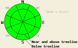
Avalanche danger is LOW for all elevations and aspects. Normal caution is advised. Small avalanches are unlikely but not impossible in isolated areas or in extreme terrain. |
|
|
|
A short lived break in the weather will occur today before the next weather system brings more snow to the forecast area late tonight and early tomorrow morning. Snowfall totals from the past 36 hours are around 5 to 9 inches with new snow density ranging from 5% to 7%. Partly cloudy skies today will allow for some sunshine, but air temperatures are expected to remain in the low 20s to low 30s for areas above 7,000'. Ridgetop winds shifted from southwest to northeast last night. Wind speeds have increased from near clam yesterday to light to moderate in speed this morning. Ridgetop wind speeds are expected to continue to increase this morning before decreasing and shifting to west this afternoon. A moderate to strong speed wind event is forecast for tonight. A short period of moderate to heavy snowfall is forecast to begin after midnight tonight and continue through early tomorrow morning.
Observations made yesterday on Carpenter Ridge (Independence Lake area), Castle Peak (Donner Summit area), and on Coyote Rock (Luther Pass area) all showed a lack of significant slab formation in the recent new snow. Several naturally triggered dry loose snow avalanches were observed on the northeast side of Castle Peak in above treeline terrain around 8,900' (photos, more info). While snowpack failure did occur here, it was not in the form of a slab. Along Carpenter Ridge, skier loading on many N-NE aspect ridgetop test slopes between 8,600' and 8,900' produced only very minor cracking, no more than 3 feet in length. Only 1 very small slab was successfully skier triggered and set into motion. This slab measure about 4 feet by 8 feet, was around 8 inches deep, and consisted entirely of storm snow. The failure layer was noted as fist hard new snow at the base of 1 finger hard wind affected snow (photos, more info). Areas of wind affected snow were highly localized and confined directly to the ridgetops. Large avalanche start zones on the summit of Carpenter Peak showed no evidence of slab formation. Snowpit data collected at Coyote Rock in below treeline terrain on a NE aspect at 7,500' again showed no evidence of slab formation and no additional evidence of instability in snowpit tests (pit profile, more info). The crusts and near surface faceted snow that exists directly below the recent new snow has shown no evidence of instability in recent days or after the addition of the light new snow load yesterday.
Today's Avalanche Concerns: Wind Slabs
Stable snow is expected to exist in the vast majority of areas today. The forecast moderate speed winds are borderline to create some blowing snow and redistribution of snow along ridgetops today. Any areas of new slab formation today or lingering unstable slabs from yesterday are expected to be limited to the recent new snow, small in size, and isolated in distribution. Areas of complex or extreme terrain may hold some small and unstable slabs. However, these slabs are not expected to be large enough to bury or injure a person without the aid of a terrain trap or other secondary terrain exposure such as cliffs and rock bands. Exercise good travel habits in order to minimize risk.
Avalanche danger is LOW for all elevations and aspects. Normal caution is advised. Small avalanches are unlikely but not impossible in isolated areas or in extreme terrain.
| 0600 temperature: | 16 to 21 deg. F. |
| Max. temperature in the last 24 hours: | 25 to 28 deg. F. |
| Average wind direction during the last 24 hours: | Southwest shifting to northeast |
| Average wind speed during the last 24 hours: | 15 mph |
| Maximum wind gust in the last 24 hours: | 37 mph |
| New snowfall in the last 24 hours: | Trace to 2 inches |
| Total snow depth: | 23 to 33 inches |
For 7000-8000 ft: |
|||
| Tuesday: | Tuesday Night: | Wednesday: | |
| Weather: | Partly cloudy skies. | Cloudy skies with snow after midnight. | Cloudy skies with snow in the morning. Mostly cloudy skies with a chance of snow showers in the afternoon. |
| Temperatures: | 26 to 33 deg. F. | 15 to 20 deg. F. | 18 to 23 deg. F. |
| Wind direction: | N shifting to W | SW | W shifting to N |
| Wind speed: | 10 to 15 mph with gusts to 25 mph in the morning, shifting and decreasing to around up to 10 mph in the afternoon. | 15 to 30 mph with gusts to 40 mph. | 20 to 25 mph with gusts to 40 mph. |
| Expected snowfall: | O in. | Up to 2 in. | 2 to 4 in. |
For 8000-9000 ft: |
|||
| Tuesday: | Tuesday Night: | Wednesday: | |
| Weather: | Partly cloudy skies. | Cloudy skies with snow after midnight. | Cloudy skies with snow in the morning. Mostly cloudy skies with a chance of snow showers in the afternoon. |
| Temperatures: | 21 to 26 deg. F. | 11 to 16 deg. F. | 15 to 20 deg. F. |
| Wind direction: | N shifting to W | W | W shifting to N |
| Wind speed: | 15 to 25 mph with gusts to 35 mph, shifting and decreasing to 10 to 20 mph in the afternoon. | 30 to 40 mph with gusts to 60 mph. | 30 to 35 mph with gusts to 55 mph. |
| Expected snowfall: | O in. | Up to 2 in. | 2 to 4 in. |


This website is owned and maintained by the non-profit arm of the Sierra Avalanche Center. Some of the content is updated by the USDA avalanche forecasters including the forecasts and some observational data. The USDA is not responsible for any advertising, fund-raising events/information, or sponsorship information, or other content not related to the forecasts and the data pertaining to the forecasts.

