In partnership with: 
|
February 16, 2012 at 8:00 am |
|
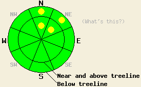
Generally LOW avalanche danger exists today. Very isolated pockets of MODERATE danger may linger near treeline and below treeline on N-NE aspects on slopes 35 degrees and steeper due to persistent slabs. On SE-S-SW-W aspects, minor warming instability may form today on recently wind loaded SE-S-SW-W aspects on slopes 37 degrees and steeper. |
|
|
|
The weather system that passed through the forecast area yesterday deposited an additional trace to 2 inches of new snow during the day yesterday. New snow totals from the past 36 hours are 5 to 8 inches across the forecast area. High pressure will build over the region today. Partly cloudy skies, light to moderate speed east winds and near to above freezing air temperatures are forecast for today. Air temperatures remain cool this morning with remote sensors between 7,000' and 9,600' reporting air temperatures in the mid teens to upper single digits. Ridgetop winds remain out of the northeast to east this morning and have decreased from strong to moderate in speed. Winds are expected to continue through this evening before decreasing to light in speed and shifting to the west for tomorrow. Mostly cloudy skies with above freezing air temperatures are expected at the mid and upper elevations for Friday.
Observations made yesterday on Castle Peak and Andesite Ridge (Donner Summit area) and on Tamarack Peak (Mount Rose area) revealed significant wind transport of new snow in near and above treeline areas. Strong NE winds were scouring snow from open areas near and above treeline on N-NE-E aspects and depositing this snow on SE-S-SW-W aspects. On Castle Peak, several snowpits in near treeline terrain on W-NW aspects between 7,900' and 8,900' revealed newly formed but stable wind slabs 8 to 18 inches thick (pit profile, photo, more info). On Andesite Ridge, whumphing caused by skier triggered collapse of faceted snow below the rain crust (from the January 26 rain event) at the base of the new snow was noted on a NE aspect at 8,000' in near treeline terrain. No shooting cracks or other evidence of propagating slab failure where observed in association with these whumphs (more info). On the far east ridge of Tamarack Peak, snowpit data obtained near treeline on a N aspect at 9,000' revealed significant faceting both above and below the rain/melt freeze crust at the base of the new snow. Both formal and informal test conducted on this weak layer produced no evidence of propagation in association with collapse (photos, more info).
Today's Avalanche Concern #1: Persistent Slabs
In the near treeline and below treeline areas on N-NE aspects that are protected from scouring by NE-E winds, isolated areas of persistent slabs may linger today. Areas where several inches of new snow sit on top of the rain crust that formed from the January 26 rain event and associated faceted snow may still allow for areas of human triggered collapse and whumphing. Observed collapse of the weak layer yesterday was highly localized, but it may continue today, allowing for the possibility of isolated human triggered slab avalanche activity. Any avalanche activity associated with failure of this weak layer would involve the 5 to 8 inches of recent new snow, plus another 1 to 4 inches of old snow at or below the crust.
Today's Avalanche Concern #2: Warming Instability
Warming instability may occur today on SE-S-SW-W aspects as solar radiation and near to above freezing air temperatures create roller ball activity from snow falling off of rocks and trees. Additional human triggered roller ball activity is expected. Small loose snow point release avalanches are possible on slopes 37 degrees and steeper. Slab avalanche activity due to warming of recently formed wind slabs near and above treeline on SE-S-SW-W aspects is unlikely but not impossible.
Generally LOW avalanche danger exists today. Very isolated pockets of MODERATE danger may linger near treeline and below treeline on N-NE aspects on slopes 35 degrees and steeper due to persistent slabs. On SE-S-SW-W aspects, minor warming instability may form today on recently wind loaded SE-S-SW-W aspects on slopes 37 degrees and steeper.
| 0600 temperature: | 13 to 15 deg. F. |
| Max. temperature in the last 24 hours: | 15 to 20 deg. F. |
| Average wind direction during the last 24 hours: | Northeast |
| Average wind speed during the last 24 hours: | 40 mph |
| Maximum wind gust in the last 24 hours: | 67 mph |
| New snowfall in the last 24 hours: | Trace to 2 inches |
| Total snow depth: | 29 to 37 inches |
For 7000-8000 ft: |
|||
| Thursday: | Thursday Night: | Friday: | |
| Weather: | Partly cloudy skies. | Partly cloudy skies, becoming mostly cloudy. | Mostly cloudy skies. |
| Temperatures: | 30 to 37 deg. F. | 16 to 24 deg. F. | 36 to 43 deg. F. |
| Wind direction: | E | E | Variable |
| Wind speed: | 10 to 15 mph with gusts to 25 mph. | 10 to 15 mph with gusts to 25 mph in the evening, becoming light. | Light winds. |
| Expected snowfall: | O in. | O in. | O in. |
For 8000-9000 ft: |
|||
| Thursday: | Thursday Night: | Friday: | |
| Weather: | Partly cloudy skies. | Partly cloudy skies, becoming mostly cloudy. | Mostly cloudy skies. |
| Temperatures: | 27 to 34 deg. F. | 19 to 26 deg. F. | 36 to 42 deg. F. |
| Wind direction: | E | E | W |
| Wind speed: | 25 to 35 mph with gusts to 55 mph. | 15 to 20 mph with gusts to 30 mph. | 10 to 15 mph with gusts to 25 mph. |
| Expected snowfall: | O in. | O in. | O in. |


This website is owned and maintained by the non-profit arm of the Sierra Avalanche Center. Some of the content is updated by the USDA avalanche forecasters including the forecasts and some observational data. The USDA is not responsible for any advertising, fund-raising events/information, or sponsorship information, or other content not related to the forecasts and the data pertaining to the forecasts.

