In partnership with: 
|
February 17, 2012 at 8:00 am |
|
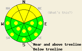
On slopes steeper than 34 degrees, MODERATE avalanche danger will exist on NW-N-NE aspects in both above and below treeline terrain due to a persistent weak layer near the base of the recent snow. Some isolated pockets of MODERATE danger may also exist on the shaded and sheltered E aspects. On SE-S-SW-W aspects pockets of MODERATE danger may form due to daytime warming on slopes 37 degrees and steeper. |
|
|
|
Temperatures started to warm last night due to a high pressure ridge allowing warm air into the region. This morning temperatures above 8000 ft had already reached the low 30's. Meanwhile an inversion exists below 7000 ft with temperatures at these lower elevations hovering in the upper 20's. The high pressure ridge should bring warmer temperatures and continued light winds to the area today. Daytime highs above 7000 ft should climb into the upper 30's and low 40's. The thin high clouds that increased last night should persist through this morning. Skies should become mostly clear as the day progresses. By tonight the cloud cover and west southwest winds should begin increasing ahead of a cold low pressure system approaching the area. Daytime highs should fall back into the upper 20's and low 30's tomorrow. This system could also bring some snow showers to the area tomorrow, but any accumulation should remain light.
Yesterday observations near Round Top Peak (photo, snowpit, and more info) and in the Blue Lakes area (video, snowpit, and more info) showed rising instability in the snowpack. Snowpit data from NE-N-NW aspects above and below treeline in both of these places indicated that the weak sugary snow below the Jan. 26th rain crust continues to weaken through a process known as faceting. While these facets continue to lose strength, observations showed that the new snow above them has started to coalesce into more of a slab layer. Stability tests revealed that once the facets break, the resulting fractures no longer stop. They can now travel along this weak layer in some areas (video showing a fracture propagating through this weak layer). These tests also showed that a person's weight could provide the trigger to initiate these kinds of fractures. By yesterday afternoon these conditions existed on slopes where the strong east winds had not scoured much of the recent snow away. The new snow had more slab-like characteristics on slopes where light east winds had allowed it to consolidate faster. In the Blue Lakes area a sun crust had formed on the sun-exposed southerly aspects by late afternoon. Observations revealed no signs of warming instabilities during the day yesterday in these areas.
Today's Avalanche Concern #1: Persistent Slabs
As the new snow continues to settle and consolidate, it will become even more of a slab layer. Unfortunately, the facets under the Jan 26th rain crust at the base of the new snow continue to grow weaker. This combination of slab formation and a persistent weak layer that continues to lose strength will provide the necessary ingredients for human triggered avalanches to become possible again today. NW-N-NE facing terrain where the strong east winds have not scoured away much of the new snow will hold the highest chance for this kind of instability. Avalanches resulting from this type of instability would entrain all of the snow snow and could easily bury a person. This kind of instability does no go away quickly and often grows more unstable days after the last storm. Careful snowpack evaluation, safe travel techniques, and cautious terrain choices can help keep backcountry travel fun and safe.
Today's Avalanche Concern #2: Warming Instability
Warming instability may occur today as solar radiation and warmer air temperatures allow enough melting for roller balls, pinwheels, and some wet point-release slides to form. Sun-exposed SE-S-SW aspects steeper than 37 degrees represent the most likely terrain for these kinds of instabilities. Some of these instabilities could grow large enough to push a person into an undesirable place, like into rocks or over a cliff or into some other terrain trap.
On slopes steeper than 34 degrees, MODERATE avalanche danger will exist on NW-N-NE aspects in both above and below treeline terrain due to a persistent weak layer near the base of the recent snow. Some isolated pockets of MODERATE danger may also exist on the shaded and sheltered E aspects. On SE-S-SW-W aspects pockets of MODERATE danger may form due to daytime warming on slopes 37 degrees and steeper.
| 0600 temperature: | 27-33 deg. F. |
| Max. temperature in the last 24 hours: | 30-37 deg. F. |
| Average wind direction during the last 24 hours: | East to northeast |
| Average wind speed during the last 24 hours: | 5-15 mph |
| Maximum wind gust in the last 24 hours: | 30-37 mph |
| New snowfall in the last 24 hours: | O inches |
| Total snow depth: | 27-37 inches |
For 7000-8000 ft: |
|||
| Friday: | Friday Night: | Saturday: | |
| Weather: | Partly cloudy this morning becoming mostly sunny this afternoon | Mostly cloudy | Cloudy with isolated snow showers in the morning then scattered snow showers in the afternoon. |
| Temperatures: | 36-43 deg. F. | 20-27 deg. F. | 29-35 deg. F. |
| Wind direction: | West | Southwest | Southwest |
| Wind speed: | Light | 10-15 mph with gusts to 25 mph | 15-20 mph with gusts to 35 mph |
| Expected snowfall: | O in. | O in. | Trace to 1 in. |
For 8000-9000 ft: |
|||
| Friday: | Friday Night: | Saturday: | |
| Weather: | Partly cloudy this morning becoming mostly sunny this afternoon | Mostly cloudy | Cloudy with isolated snow showers in the morning then scattered snow showers in the afternoon. |
| Temperatures: | 36-42 deg. F. | 19-26 deg. F. | 26-32 deg. F. |
| Wind direction: | West | West | Southwest |
| Wind speed: | around 10 mph with gusts to 20 mph | 20-30 mph with gusts to 45 mph | 35-45 mph with gusts to 65 mph |
| Expected snowfall: | O in. | O in. | Trace to 1 in. |


This website is owned and maintained by the non-profit arm of the Sierra Avalanche Center. Some of the content is updated by the USDA avalanche forecasters including the forecasts and some observational data. The USDA is not responsible for any advertising, fund-raising events/information, or sponsorship information, or other content not related to the forecasts and the data pertaining to the forecasts.

