In partnership with: 
|
December 8, 2009 at 8:00 am |
|
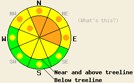
Near and above treeline CONSIDERABLE avalanche danger exists on N-NE-E aspects 32 degrees and steeper. Pockets of CONSIDERABLE danger exist on NW aspects. Below treeline pockets of CONSIDERABLE danger exist on NW-N-NE-E aspects 32 degrees and steeper. |
|
|
|
A small, high-pressure ridge should keep cold, clear weather over the forecast area through tomorrow. Temperature should remain very cold with highs in the teens and lows below zero above 7000'. The light southwest winds will make these frigid temperatures seem even colder. By tomorrow this ridge should start to break down as some clouds move into the region causing temperatures to start warming back up.
Observations:
Yesterday, several small, natural avalanches occurred on 32-34-degree, N-NE-facing aspects between 6500' and 7000' in the Pole Creek Drainage (photos and profile here). Another similar slide occurred on the Carpenter Ridge Road on a 37-degree, NE aspect at 7260' (photo). All of these small avalanches released due to failure of a facet layer near a thin rain crust. Mt. Rose Ski Patrol also reported a natural avalanche in a closed, uncontrolled area on an E aspect. The Oct. 19th facet layer acted as the failure layer for this slide. In the Pole Creek Drainage and on Carpenter Ridge widespread skier-triggered whumpfing, snowpack collapse, and shooting cracks up to 90' long occurred. On Carpenter Ridge these instabilities existed up to 8400' (snow pit profile here). A facet layer near a rain crust or the Oct. 19th facet layer failed in all of these instabilities.
Avalanche concern #1:
Today, in areas where a persistent weak layer exists underneath the new snow, natural avalanches remain possible, and human-triggered avalanches will be likely. These weak layers could include the Oct. 19th facet layer or the facets near the thin rain crust. These weak layers will most likely exist on NW-N-NE-E aspects that had some protection from the E-NE winds that scoured slopes in Nov. Snowpit tests and observations have shown that these layers will fail in response to the added weight of a person, and that once they break, the fracture can propagate through the snowpack along those layers. Any slopes steeper than 32 degrees where these persistent weak layers exist hold the potential for avalanche activity.
Avalanche concern #2:
The moderate southwest winds during this storm have formed wind slabs on the N-NE-E aspects. These slabs will be most prevalent near and above treeline on open slopes near ridgelines. These slabs will continue to grow slowly as the light to moderate southwest winds continue to transport some snow. These newly formed wind slabs will be sitting on old ice crusts, wind scoured surfaces, and in some areas on top of the previously mentioned weak layers. The new snow should consolidate slowly due to the persistent cold, clear weather. This instability could remain active today. Use clues like drifted snow, cornices, ripples, and other wind created textures to determine where wind-loading has occurred. Wind-loaded slopes steeper than 34 degrees will also hold avalanche potential today.
Near and above treeline CONSIDERABLE avalanche danger exists on N-NE-E aspects 32 degrees and steeper. Pockets of CONSIDERABLE danger exist on NW aspects. Below treeline pockets of CONSIDERABLE danger exist on NW-N-NE-E aspects 32 degrees and steeper.
| 0600 temperature: | 3 deg. F. |
| Max. temperature in the last 24 hours: | 17 deg. F. |
| Average wind direction during the last 24 hours: | West southwest shifting to the northeast then back to the west southwest |
| Average wind speed during the last 24 hours: | 15 mph |
| Maximum wind gust in the last 24 hours: | 28 mph |
| New snowfall in the last 24 hours: | North of Hwy 50: 2-3 inches - South of Hwy 50 4-6 inches |
| Total snow depth: | 26-40 inches |
For 7000-8000 ft: |
|||
| Tuesday: | Tuesday Night: | Wednesday: | |
| Weather: | Sunny | Partly cloudy becoming mostly cloudy after midnight | Mostly cloudy |
| Temperatures: | 12 to 19 deg. F. | 2 below zero to 5 deg. F. | 21 to 28 deg. F. |
| Wind direction: | West southwest | Southwest | Southwest |
| Wind speed: | 10-15 mph | 10-15 mph decreasing after midnight | 10 mph |
| Expected snowfall: | O in. | O in. | O in. |
For 8000-9000 ft: |
|||
| Tuesday: | Tuesday Night: | Wednesday: | |
| Weather: | Sunny | Partly cloudy becoming mostly cloudy after midnight | Mostly cloudy |
| Temperatures: | 10 to 17 deg. F. | 1 to 8 deg. F. | 20 to 27 deg. F. |
| Wind direction: | West southwest | west | Southwest |
| Wind speed: | 10-20 mph with gusts to 35 mph | 10-15 mph with gusts to 35 mph | 10-15 mph with gusts to 30 mph |
| Expected snowfall: | O in. | O in. | O in. |


This website is owned and maintained by the non-profit arm of the Sierra Avalanche Center. Some of the content is updated by the USDA avalanche forecasters including the forecasts and some observational data. The USDA is not responsible for any advertising, fund-raising events/information, or sponsorship information, or other content not related to the forecasts and the data pertaining to the forecasts.

