In partnership with: 
|
March 20, 2012 at 7:00 am |
|
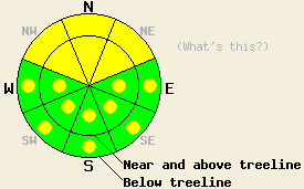
Both above and below treeline, MODERATE avalanche danger remains on NW-N-NE aspects on slopes 35 degrees and steeper. Even though avalanches have become more difficult to trigger today, huge, dangerous deep slab avalanches with serious consequences remain possible on these aspects. On all other aspects pockets of MODERATE danger exist on slopes 35 degrees and steeper. |
|
|
|
A warm front passing across the forecast area should bring continued cloud cover and warmer temperatures to the region today. This morning most remote sensors already show temperatures in the upper 20's and low 30's. In many cases these early morning temperatures represent the maximum temperatures during the last 24 hours as well. Daytime highs could climb into the mid 30's and low 40's above 7000 ft. Some isolated snow showers that produce little to no accumulation could also occur today as a result of the warm front. By tomorrow a small high pressure ridge should form over the region bringing sunny skies and temperatures in the low to upper 40's above 7000 ft.
Yesterday observations on Trimmer Peak (snowpit) and on Jakes Peak (photos, more info) showed continued settlement and consolidation in the recent storm snow. Some very small skier-triggered cracking still occurred on steep wind-loaded test slopes near the summit ridge line on Jakes Peak on NE and SE aspects. This cracking and the wind slabs dissipated quickly below the ridge line (photo). Skiers on Tamarack Peak reported similar consolidation and no signs of instability in the storm snow in that area yesterday. Snowpit data from deeper in the snowpack on Trimmer and on Jakes showed the rain/wet snow layer within the storm snow remains wet, but that it is slowly refreezing. Below 8500 ft this layer was four to eight inches thick and very wet. Above 8500 ft this layer become much thinner and more refrozen. The persistent weak layer of crusts and weak sugary snow (facets) still exits between five and eight feet down in the snowpack. Tests on this deeply buried layer still indicated that it remains weak and that fractures can easily travel through this layer if it breaks.
Today's Primary Avalanche Concern: Persistent Deep Slabs
Due to the upper snowpack continuing to strengthen and the depth of the persistent weak layer, triggering a fracture in this layer continues to become more and more difficult. However, if this layer does break, tests indicate that huge destructive avalanches could still result. These kind of avalanches will remain possible today on NW-N-NE aspects at all elevations. Areas near exposed rock outcrops and cliffs, steep unsupported slopes, complex terrain features, and slopes with trigger points represent some locations where the persistent weak layer could remain closer to the surface allowing for the possiblity that people on the surface could send enough force down to that layer to initiate a fracture. That fracture could then propagate out into much deeper parts of the snowpack. Larger triggers like large cornice failures or other avalanches could also produce these deep slab avalanches today. Even though the likely hood of triggering one of these slides remain low, the consequences of such a slide could be very serious.
Today's Secondary Avalanche Concern: Wind Slabs and Storm Slabs
Triggering a wind slab or a storm slab that fails on a weakness that formed during the storm has become unlikely in most places because of the settlement and consolidation that has occurred over the last few days. Some isolated pockets of terrain where these slabs still remain fragile could still exist on the most heavily wind-loaded N-NE-E aspects and cross loaded NW and SE gullies in near and above treeline terrain. Steep unsupported slopes and steep complex terrain could also hold some pockets of unstable storm snow. Any avalanches that occur today could step down and become the deep slab avalanches mentioned above.
Today's Third Avalanche Concern: Wet Snow Instabilities
As temperatures climb well above freezing today, some melting should start to occur in the snowpack. In most places consistent cloud cover should prevent large wet snow instabilities from forming. Unfortunately this cloud cover could allow warming to occur on all aspects. Some small wet snow instabilities like roller balls, pinwheels, and wet loose avalanches could occur today on any steep slopes especially near trees, rocks, cliffs and other exposed objects that may warm up faster than the snowpack. If the clouds dissipate sooner than forecasted wet snow instabilities should become larger and more widespread and wet slab avalanches could become possible on the most sun exposed slopes.
Both above and below treeline, MODERATE avalanche danger remains on NW-N-NE aspects on slopes 35 degrees and steeper. Even though avalanches have become more difficult to trigger today, huge, dangerous deep slab avalanches with serious consequences remain possible on these aspects. On all other aspects pockets of MODERATE danger exist on slopes 35 degrees and steeper.
| 0600 temperature: | 24-30 deg. F. |
| Max. temperature in the last 24 hours: | 29-34 deg. F. |
| Average wind direction during the last 24 hours: | Southwest |
| Average wind speed during the last 24 hours: | 5-15 mph |
| Maximum wind gust in the last 24 hours: | 33 mph |
| New snowfall in the last 24 hours: | Trace to 0 inches |
| Total snow depth: | 50-88 inches |
For 7000-8000 ft: |
|||
| Tuesday: | Tuesday Night: | Wednesday: | |
| Weather: | Cloudy to mostly cloudy with isolated snow showers | Partly cloudy | Sunny |
| Temperatures: | 37-43 deg. F. | 27-32 deg. F. | 44-50 deg. F. |
| Wind direction: | Southwest | Southwest | West shifting to the southwest in the afternoon |
| Wind speed: | 10-20 mph with gusts to 35 mph | 10-20 mph | 10-20 mph increasing to 15-25 mph with gusts to 35 mph in the afternoon |
| Expected snowfall: | trace to 0 in. | O in. | O in. |
For 8000-9000 ft: |
|||
| Tuesday: | Tuesday Night: | Wednesday: | |
| Weather: | Cloudy to mostly cloudy with isolated snow showers | Partly cloudy | Sunny |
| Temperatures: | 33-38 deg. F. | 25-30 deg. F. | 38-44 deg. F. |
| Wind direction: | West | Southwest | Southwest |
| Wind speed: | 20-35 mph with gusts to 50 mph | 15-30 mph with gusts to 45 mph | 20-30 mph with gusts to 45 mph |
| Expected snowfall: | trace to 0 in. | O in. | O in. |


This website is owned and maintained by the non-profit arm of the Sierra Avalanche Center. Some of the content is updated by the USDA avalanche forecasters including the forecasts and some observational data. The USDA is not responsible for any advertising, fund-raising events/information, or sponsorship information, or other content not related to the forecasts and the data pertaining to the forecasts.

