In partnership with: 
|
March 29, 2012 at 6:55 am |
|
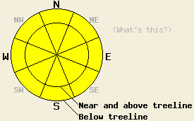
Avalanche danger is MODERATE for all elevations and aspects on slopes 35 degrees and steeper due to warming instability. Ongoing and new concerns exist for large destructive deep slab avalanches on NW-N-NE aspects both above and below treeline on slopes 35 degrees and steeper. |
|
|
|
Warm weather is on tap for today and tomorrow as maximum daytime air temperatures push well above freezing. Remote sensors are reporting air temperatures in the mid to upper 20s this morning with highs above 7,000' expected in the upper 30s to near 50 degrees. Ridgetop winds remain moderate in speed out of the southwest and will continue today and tonight before increasing in speed on Friday. Mostly cloudy skies are expected as weather systems pass by to the north of the forecast area. Some light precipitation is possible over the next couple of days along the Sierra Crest with little to no accumulation.
Observations made yesterday on Hidden Peak (West Shore Tahoe area) revealed a new layer of near crust facets that has formed above and below the rain crust that was buried on March 16th. This was observed on a N aspect a 9,100' where the crust was 1 cm thick, much thinner than lower elevation areas that received substantially more rain. This layer was buried around 3 feet below the snow surface with snowpit tests indicating that fractures were likely to propagate along this weak layer once triggered (pit profile, video). In wind loaded areas along the summit ridge of Hidden Peak and along the summit ridge of Becker Peak/Talking Mountain (Echo Summit area) ski cuts, cornice collapses, and snowpit tests all failed to reveal any significant evidence of slab avalanche instability despite several density inversions within the top few feet of the snowpack and snowfall rates around 1 inch per hour for much of the morning. In both areas, early indications of wet loose snow instability was observed below 6,800' during the early afternoon hours on N-NE aspects (more info).
Today's Primary Avalanche Concern: Wet snow instability
Well above freezing air temperatures, cloud cover, and late March solar radiation will cause warming instability of the top portion of the snowpack today on all aspects and at all elevations. Small natural and larger human triggered wet loose snow avalanches are possible today as the snowpack is rapidly stressed by the warming temperatures. The lack of near surface slab avalanche instability yesterday is expected to keep wet snow instability today in the form of wet loose snow avalanches rather than wet slab avalanches. Secondary terrain hazards such as cliffs and terrain traps could greatly increase the consequences of becoming caught in a wet loose snow avalanche.
Today's Secondary Avalanche Concern: Persistent Deep Slabs
There are now two different faceted layers within the snowpack that give concern for deep slab avalanches. The first is the long discussed persistent weak layer of old crusts and faceted snow that exists anywhere from 4 feet to 8 feet deep in the snowpack and contributed to large avalanches in early and mid March. The second layer is the newly formed facets that exist in at least some areas above and below the rain crust that was buried on March 16. Both of these layers exist above and below treeline on NW-N-NE aspects. Recent snowpit tests indicate that collapse of either of these weak layers is likely to cause propagating slab failure deep within the snowpack. Transmitting sufficient force through the snowpack to trigger a deep slab avalanche on the lower weak layer remains very difficult due to the depth of the weak layer and the strength of the overlying slab. The upper weak layer at 3 feet deep is well within the zone of stress applied to the snowpack by a single skier or snowmobiler. Areas where either of these weak layers are within 4 feet of the snow surface such as near exposed rock outcrops, cliffs, unsupported slopes, and other complex terrain features are the most likely areas to trigger snowpack failure. Large triggers such as cornice collapse, other avalanches, or multiple persons on the same slope could provide sufficient force to trigger a deep slab avalanche. Any deep slab avalanches that occur at this time will be large and destructive.
Avalanche danger is MODERATE for all elevations and aspects on slopes 35 degrees and steeper due to warming instability. Ongoing and new concerns exist for large destructive deep slab avalanches on NW-N-NE aspects both above and below treeline on slopes 35 degrees and steeper.
| 0600 temperature: | 24 to 27 deg. F. |
| Max. temperature in the last 24 hours: | 29 to 33 deg. F. |
| Average wind direction during the last 24 hours: | Southwest |
| Average wind speed during the last 24 hours: | 45 mph |
| Maximum wind gust in the last 24 hours: | 93 mph |
| New snowfall in the last 24 hours: | 2 to 8 inches |
| Total snow depth: | 54 to 87 inches |
For 7000-8000 ft: |
|||
| Thursday: | Thursday Night: | Friday: | |
| Weather: | Mostly cloudy skies. | Mostly cloudy skies. | Mostly cloudy skies. |
| Temperatures: | 42 to 50 deg. F. | 27 to 34 deg. F. | 48 to 54 deg. F. |
| Wind direction: | SW | SW | SW |
| Wind speed: | 15 to 25 mph with gusts to 40 mph. | 15 to 25 mph with gusts to 40 mph. | 15 to 20 mph with gusts to 40 mph, increasing to 25 to 30 mph with gusts to 50 mph in the afternoon. |
| Expected snowfall: | O in. | O in. | O in. |
For 8000-9000 ft: |
|||
| Thursday: | Thursday Night: | Friday: | |
| Weather: | Mostly cloudy skies. | Mostly cloudy skies. | Mostly cloudy skies. |
| Temperatures: | 38 to 44 deg. F. | 26 to 33 deg. F. | 41 to 47 deg. F. |
| Wind direction: | SW | SW | SW |
| Wind speed: | 30 to 40 mph with gusts to 60 mph. | 30 to 40 mph with gusts to 60 mph. | 35 to 45 mph with gusts to 70 mph. |
| Expected snowfall: | O in. | O in. | O in. |


This website is owned and maintained by the non-profit arm of the Sierra Avalanche Center. Some of the content is updated by the USDA avalanche forecasters including the forecasts and some observational data. The USDA is not responsible for any advertising, fund-raising events/information, or sponsorship information, or other content not related to the forecasts and the data pertaining to the forecasts.

