In partnership with: 
|
March 31, 2012 at 6:59 am |
|
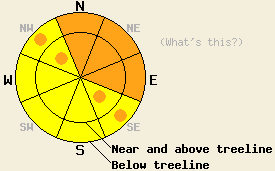
This morning MODERATE avalanche danger exists on all aspects at all elevations on slopes 35 degrees and steeper. By later this afternoon and this evening, CONSIDERABLE avalanche danger should develop at all elevations on the N-NE-E aspects with pockets CONSIDERABLE danger on the NW and SE aspects. Natural avalanches will become possible and human triggered avalanches will become likely in these areas due to strong wind loading, intense snowfall, and ongoing deep slab avalanche concerns. |
|
|
|
The winds and cloud cover have increased ahead of a cold front approaching the forecast area. The gale force winds should continue through this evening until after the cold front passes over the region. Light precipitation should begin to fall this morning then increase in intensity this afternoon and evening. With snow levels starting between 7000 and 7500 feet this morning, some areas below that elevation could receive rain until snow levels drop to Lake level in the early afternoon. Above 7000 feet the forecast calls for 8-16 inches of new snow by tomorrow morning with most of the accumulation occurring this afternoon and evening. During the most intense periods of snowfall accumulation rates could reach three inches per hour. By midnight the snow showers should start to dissipate and winds should shift towards the north and decrease. Tomorrow the moderate northerly winds should continue and cloud cover should continue to decrease. Tomorrow's temperatures should still remain cooler than normal behind the cold front.
Snowpits and observations on Andesite Ridge, in Deep Creek, and on Meiss Ridge all showed some improvement in the persistent weak layers buried in the snowpack yesterday. On Andesite Ridge (more info) and on Meiss Ridge (snowpit, more info) probing indicated that the older more deeply buried weak layer has compressed and has become more difficult to locate. Tests on this layer in Deep Creek indicated that propagation along this layer has become unlikely since March 24 when tests showed propagation remained likely (snowpit, more info). This data brings the number of observations showing more stable results on the deeply buried weak layer up to 7 out of 21 since March 18th. Snowpit tests on the upper weak layer on Meiss Ridge also showed that it had gained some strength and that propagation along this layer in that area has become unlikely. In all three areas wet unsupportable snow existed on all aspects at all elevations yesterday. Roller balls and wet loose point releases occurred in each of these areas due to warming instabilities (photos form Andesite, photos from Deep Creek, more info from Meiss).
Today's Primary Avalanche Concern: Wind Slabs and Storm Slabs
As new snow and strong winds affect the forecast area today, new wind slabs will form on wind loaded N-NE-E and cross loaded NW and SE aspects. These slabs could also exist on more protected slopes today due to strong winds at all elevations. New soft storm slabs could also form on open non-wind affected slopes in below treeline terrain as the snow accumulates today. This morning both of these types of slabs should remain small due to the fact that the majority of the snowfall should not occur until this afternoon. As the snowfall rates intensify this afternoon and evening, the new wind slabs and soft slabs could grow much larger in a short period of time. The bonds holding these slabs to the snowpack will likely not be able to keep pace with the rapidly growing wind slabs and storm slabs allowing natural avalanches involving these new slabs to become possible this afternoon and evening. Human trigging of these kinds of avalanches will should become likely by this afternoon and evening.
Today's Secondary Avalanche Concern: Rain on Snow and Wet Snow Instability
Below 7500 feet rain falling on the snowpack combined with a weak / non-existent overnight refreeze will allow wet snow instabilities to remain possible on all aspects this morning. Most of these instabilities should manifest as roller balls, pinwheels, and wet loose avalanches. However, some wet slab avalanches may also become possible on slopes that receive the most rain. Terrain hazards such as cliffs and terrain traps could increase the consequences of any size wet snow avalanches today.
Today's Third Avalanche Concern: Persistent Deep Slabs
In addition to the old persistent weak layer buried four to eight feet deep in the snowpack, a second layer of weak sugary snow has formed higher in the snowpack in some areas. Fortunately, the more shallow weak layer that would remain easier to trigger seems limited in its distribution, and a very strong deep snowpack above the older weak layer continues to prevent much force from reaching that layer making it very difficult to trigger a deep slab avalanche. Unfortunately, recent snowpit tests still indicate that if either of these weak layers break the resulting fracture could propagate along the layer resulting in large destructive deep slab avalanches with serious consequences. These kind of avalanches will remain possible today on NW-N-NE aspects at all elevations. Areas where a more shallow snowpack exists like areas near exposed rock outcrops and cliffs, steep unsupported slopes, complex terrain features, and slopes with trigger points represent some locations where the persistent weak layers could remain close enough to the surface for people on the surface break these layers. Larger triggers like large cornice failures, other avalanches (see above), or multiple people on the same slope could also produce these deep slab avalanches.
This morning MODERATE avalanche danger exists on all aspects at all elevations on slopes 35 degrees and steeper. By later this afternoon and this evening, CONSIDERABLE avalanche danger should develop at all elevations on the N-NE-E aspects with pockets CONSIDERABLE danger on the NW and SE aspects. Natural avalanches will become possible and human triggered avalanches will become likely in these areas due to strong wind loading, intense snowfall, and ongoing deep slab avalanche concerns.
| 0600 temperature: | 30-34 deg. F. |
| Max. temperature in the last 24 hours: | 39-48 deg. F. |
| Average wind direction during the last 24 hours: | Southwest |
| Average wind speed during the last 24 hours: | 40-50 mph |
| Maximum wind gust in the last 24 hours: | 89 mph |
| New snowfall in the last 24 hours: | O inches |
| Total snow depth: | 41-81 inches |
For 7000-8000 ft: |
|||
| Saturday: | Saturday Night: | Sunday: | |
| Weather: | Cloudy with light snow in the morning. Snow should increase and become heavier this afternoon. | Cloudy with moderate to heavy snow in the evening. Snow showers should decrease after midnight | Mostly cloudy with a chance of snow showers in the morning. Clouds decreasing in the afternoon. |
| Temperatures: | 35-43 deg. F. | 12-19 deg. F. | 31-37 deg. F. |
| Wind direction: | Southwest | Southwest shifting to the northwest | Northwest |
| Wind speed: | 60-70 mph with gusts to 95 mph decreasing to 50-60 mph with gusts to 85 mph in the afternoon | 40-50 mph with gusts to 80 mph decreasing to 20-25 mph with gusts to 35 mph after midnight | 15-20 mph with gusts to 30 mph |
| Expected snowfall: | 4-8 in. | 3-6 in. | O in. |
For 8000-9000 ft: |
|||
| Saturday: | Saturday Night: | Sunday: | |
| Weather: | Cloudy with light snow in the morning. Snow should increase and become heavier this afternoon. | Cloudy with moderate to heavy snow in the evening. Snow showers should decrease after midnight | Mostly cloudy with a chance of snow showers in the morning. Clouds decreasing in the afternoon. |
| Temperatures: | 30-36 deg. F. | 8-15 deg. F. | 24-30 deg. F. |
| Wind direction: | Southwest | Southwest shifting to the northwest after midnight | North |
| Wind speed: | 65-75 mph with gusts to 105 mph | 60-70 mph with gusts to 100 mph decreasing to 30-40 mph with gusts to 55 mph after midnight | 20-30 mph with gusts to 45 mph |
| Expected snowfall: | 6-10 in. | 3-6 in. | O in. |


This website is owned and maintained by the non-profit arm of the Sierra Avalanche Center. Some of the content is updated by the USDA avalanche forecasters including the forecasts and some observational data. The USDA is not responsible for any advertising, fund-raising events/information, or sponsorship information, or other content not related to the forecasts and the data pertaining to the forecasts.

