In partnership with: 
|
April 2, 2012 at 7:00 am |
|
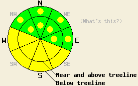
Both above and below treeline, avalanche danger is MODERATE on SE-S-SW-W aspects on slopes 35 degrees and steeper. Additional pockets of MODERATE danger exist on NW-N-NE-E aspects on slopes 35 degrees and steeper. Ongoing concerns exist for human triggered avalanches due to warming instability, lingering storm snow instability, and persistent deep slab instability. |
|
|
|
High pressure is building over the forecast area today. Thin high cloud cover will create partly cloudy skies, but will still allow for plenty of sunshine and incoming solar radiation. An additional trace to 2 inches of new snow accumulated yesterday morning before the most recent storm system cleared out of the forecast area. Storm totals from late Friday through yesterday morning are running 12 to 22 inches. Remote sensors are reporting air temperatures above 8,000' this morning in the upper teens to low 20s. Maximum daytime air temperatures are forecast to reach the mid 30s to mid 40s today for areas above 7,000'. Ridgetop winds shifted from southwest to east overnight and are moderate in speed this morning. Winds are forecast to shift back to the southwest tomorrow with an additional 10 degrees of warming and some increase in cloud cover.
Evidence of a number of small to medium size natural avalanches that occurred late Saturday night and early Sunday morning were apparent yesterday on Mt. Judah and Wildflower Ridge (Donner Summit area) and on Mt. Tallac (Desolation Wilderness area). These avalanche were noted to have failed 1 to 2 feet deep in the snowpack on N-NE aspects in near and above treeline terrain (photos, more info). Additional medium size natural avalanche activity was observed to occur yesterday under warming instability conditions on Flagpole and Cathedral Peaks (Echo Summit area) (photo, more info). In both the Donner Summit area and on Hidden Peak (West Shore Tahoe area) a density inversion was apparent within the new snow. This was at the same depth as the snowpack failure layer in nearby avalanche activity and snowpack failure in snowpit tests and ski cuts on test slopes on N-NE aspects (video, more info). Snowpit data collected in the Candy Land portion of Grouse Canyon (Outside Bear Valley Ski Area) indicated an increase in stability within the storm snow with instability from the early morning hours that lead to small skier triggered avalanche activity no longer propagating by mid day (pit profile, more info).
Today's Primary Avalanche Concern: Warming Instability
Above freezing air temperatures and April levels of incoming solar radiation will lead to areas of wet snow and warming instability today in a variety of sun exposed areas. Any areas of significant wind loading today by east winds onto SE-S-SW-W aspects may hold new slabs made further unstable by warming. More wind protected areas are more likely to experience roller ball and wet loose snow avalanche activity.
Today's Secondary Avalanche Concern: Storm Slabs and Wind Slabs
Pockets of continued storm snow and wind slab instability that existed yesterday both above and below treeline may linger in pockets today on NW-N-NE aspects. Some amount of wind scouring will have occurred last night from east winds, especially over the higher terrain that did not form a melt freeze crust yesterday afternoon. Despite some wind scouring, shallow slabs are expected to remain. Human triggered slab avalanches 1 to 2 feet deep remain possible today in these areas.
Today's Tertiary Avalanche Concern: Persistent Deep Slabs
There are one to two persistent weak layers buried in the snowpack in many areas on NW-N-NE aspects both above and below treeline. These weak layers of old crust and faceted snow crystals are buried anywhere from 4 to 8+ feet deep in the snowpack in most places. Due to the strength of the middle and upper portions of the snowpack these layers are difficult to trigger and cause snowpack failure. However, recent snowpit tests continue to indicate that if either of these weak layers collapse, the resulting fracture is likely to propagate along the layer and result in a large destructive deep slab avalanche. The areas of greatest concern remain focused on relativity shallow snowpack areas where these weak layers are closer to the snow surface such as near exposed rock outcrops and cliffs, steep unsupported slopes, and complex terrain features that all represent trigger points. Larger triggers such as large cornice collapses, other avalanches, or multiple people on the same slope could also trigger a deep slab avalanche.
Both above and below treeline, avalanche danger is MODERATE on SE-S-SW-W aspects on slopes 35 degrees and steeper. Additional pockets of MODERATE danger exist on NW-N-NE-E aspects on slopes 35 degrees and steeper. Ongoing concerns exist for human triggered avalanches due to warming instability, lingering storm snow instability, and persistent deep slab instability.
| 0600 temperature: | 18 to 20 deg. F. |
| Max. temperature in the last 24 hours: | 29 to 34 deg. F. |
| Average wind direction during the last 24 hours: | Southwest shifting to East |
| Average wind speed during the last 24 hours: | 16 mph |
| Maximum wind gust in the last 24 hours: | 33 mph |
| New snowfall in the last 24 hours: | Trace to 2 inches |
| Total snow depth: | 51 to 93 inches |
For 7000-8000 ft: |
|||
| Monday: | Monday Night: | Tuesday: | |
| Weather: | Partly cloudy skies. | Mostly cloudy skies. | Mostly cloudy skies. |
| Temperatures: | 39 to 46 deg. F. | 25 to 32 deg. F. | 50 to 56 deg. F. |
| Wind direction: | East | Southeast | Southwest |
| Wind speed: | 20 to 30 mph with gusts to 45 mph, decreasing to 15 to 25 mph with gusts to 35 mph in the afternoon. | 15 to 20 mph with gusts to 30 mph. | 15 to 20 mph with gusts to 30 mph, increasing to 25 to 30 mph with gusts to 50 mph in the afternoon. |
| Expected snowfall: | O in. | O in. | O in. |
For 8000-9000 ft: |
|||
| Monday: | Monday Night: | Tuesday: | |
| Weather: | Partly cloudy skies. | Mostly cloudy skies. | Mostly cloudy skies. |
| Temperatures: | 34 to 41 deg. F. | 26 to 33 deg. F. | 43 to 49 deg. F. |
| Wind direction: | East | East shifting to south | Southwest |
| Wind speed: | 30 to 40 mph with gusts to 55 mph, decreasing to 25 to 35 mph with gusts to 50 mph in the afternoon. | 20 to 30 mph with gusts to 40 mph, shifting and decreasing to 15 to 20 mph with gusts to 30 mph after midnight. | 15 to 25 mph with gusts to 35 mph, increasing to 30 to 40 mph with gusts to 60 mph in the afternoon. |
| Expected snowfall: | O in. | O in. | O in. |


This website is owned and maintained by the non-profit arm of the Sierra Avalanche Center. Some of the content is updated by the USDA avalanche forecasters including the forecasts and some observational data. The USDA is not responsible for any advertising, fund-raising events/information, or sponsorship information, or other content not related to the forecasts and the data pertaining to the forecasts.

