In partnership with: 
|
April 8, 2012 at 6:48 am |
|
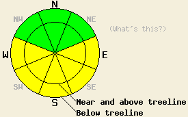
Early this morning, avalanche danger is LOW for all elevations and aspects. MODERATE avalanche danger will develop in response to daytime warming on E-SE-S-SW-W aspects at all elevations on slopes 35 degrees and steeper. |
|
|
|
High pressure over the forecast area will continue to dominate the regional weather today. Another round of well above freezing air temperatures is forecast for today along with gusty afternoon winds. Remote sensors are reporting air temperatures above 8,000' in the low to mid 30s this morning. Maximum daytime air temperatures above 7,000' are forecast to reach the mid 40s to mid 50s today. Ridgetop winds remain out of the south to southwest this morning and are moderate in speed. Moderate speed winds with strong gusts over the upper elevation ridgetops are expected for today. For tomorrow, expect similar air temperatures and winds with an increase in cloud cover.
Observations made yesterday on Waterhouse Peak (Luther Pass area) and along Frog Lake Ridge (Carson Pass area), all showed evidence of stable snowpack conditions. Formal and informal tests performed in recently wind loaded areas revealed either an absence of a surface wind slab or a stable wind slab at the snow surface that did not propagate fracture when forced to fail. Melt freeze crusts existed on all but the most sun sheltered north aspects in both areas (photo, pit profile, more info).
Today's Primary Avalanche Concern: Wet Snow
April levels of solar radiation, clear skies this morning, and daytime highs well above freezing will allow for wet snow instabilities to form on E-SE-S-SW-W aspects. Most areas of instability are expected as roller balls, pinwheels and wet loose snow avalanches. Some amount of wet surface snow is also possible on sun exposed NW-N-NE aspects given the high sun angle this time of year.
Other things to think about: The Persistent weak layer:
Deep slab avalanches failing on the old crust and faceted snow weak layer on NW-N-NE aspects has become unlikely at this time. Due to the depth (5 to 8 ft down) of the persistent weak layer and the strength of the snow above it, triggering a deep slab avalanche would require an extremely large trigger or significant weakening of the snowpack due to melt over the next several weeks.
Early this morning, avalanche danger is LOW for all elevations and aspects. MODERATE avalanche danger will develop in response to daytime warming on E-SE-S-SW-W aspects at all elevations on slopes 35 degrees and steeper.
| 0600 temperature: | 32 to 34 deg. F. |
| Max. temperature in the last 24 hours: | 41 to 48 deg. F. |
| Average wind direction during the last 24 hours: | South - Southwest |
| Average wind speed during the last 24 hours: | 22 mph |
| Maximum wind gust in the last 24 hours: | 53 mph |
| New snowfall in the last 24 hours: | O inches |
| Total snow depth: | 43 to 85 inches |
For 7000-8000 ft: |
|||
| Sunday: | Sunday Night: | Monday: | |
| Weather: | Sunny skies. | Partly cloudy skies. | Partly cloudy skies. |
| Temperatures: | 47 to 55 deg. F. | 32 to 40 deg. F. | 49 to 57 deg. F. |
| Wind direction: | S | S | S |
| Wind speed: | 10 to 15 mph with gusts to 25 mph, increasing to 25 to 30 mph with gusts to 40 mph in the afternoon. | 15 to 25 mph with gusts to 40 mph. Gusts decreasing to 35 mph after midnight. | 15 to 25 mph with gusts to 40 mph. |
| Expected snowfall: | O in. | O in. | O in. |
For 8000-9000 ft: |
|||
| Sunday: | Sunday Night: | Monday: | |
| Weather: | Sunny skies. | Partly cloudy skies. | Partly cloudy skies. |
| Temperatures: | 43 to 48 deg. F. | 25 to 35 deg. F. | 42 to 50 deg. F. |
| Wind direction: | S | S | S |
| Wind speed: | 25 to 35 mph with gusts to 60 mph. | 25 to 35 mph with gusts to 60 mph. | 35 to 40 mph decreasing to 25 to 30 mph in the afternoon. Gusts to 60 mph. |
| Expected snowfall: | O in. | O in. | O in. |


This website is owned and maintained by the non-profit arm of the Sierra Avalanche Center. Some of the content is updated by the USDA avalanche forecasters including the forecasts and some observational data. The USDA is not responsible for any advertising, fund-raising events/information, or sponsorship information, or other content not related to the forecasts and the data pertaining to the forecasts.

