In partnership with: 
|
April 12, 2012 at 6:59 am |
|
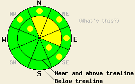
On slopes steeper than 35 degrees near and above treeline, MODERATE avalanche danger will exist on N-NE-E aspects with pockets of MODERATE danger on the NW and SE aspects due to new snow and wind loading. Pockets of MODERATE danger may also form on below treeline NW-N-NE-E-SE aspects on slopes steeper than 35 degrees. Human triggered avalanches will be possible today. The avalanche danger will increase tonight and tomorrow morning as larger natural avalanche activity becomes possible. |
|
|
|
After adding dropping 4-6 inches of snow onto the mountains in the last 24 hours the first storm of the week has exited the region. A second stronger low pressure system hot on the heels of this first system should bring more snow, stronger winds, and colder temperatures to the area through tomorrow night. Snow fall should start to pick back up again this morning with another 3-6 inches expected above 7000 ft today. The heaviest snowfall should occur tonight and tomorrow morning as the main part of the storm arrives. The forecast calls for another 7-16 inches of snow above 7000 ft and 4-8 inches at Lake level. Temperatures should remain in the teens and 20's through tomorrow and the southwest winds should remain strong until tomorrow afternoon when they may start to decrease. Click here for more information from the Reno NWS.
Yesterday small wind slabs up to 10 inches deep had started to form on Elephants Back (photos, video, more info) and on Donner Peak (photos, more info) by mid afternoon. In both areas ski cuts on test slopes produced some cracking and sluffing but no slab failures. Snowpit tests on Elephants Back (video) showed that these wind slabs could fail in response to the weight of a person while tests on Donner Peak showed less sensitive results. On Elephants Back two small natural avalanches had already occurred along the heavily wind loaded ridgelines. These slides likely failed due to cornices falling onto the slope from above. In both areas the wind slabs quickly dissipated as one moved down slope away from the ridgelines. In non wind affected areas, 2 to 4 inches of new snow had fallen by late afternoon. This new snow fell on top of a hard refrozen crust at the higher elevations and on 4-6 inches of slowly refreezing wet snow at lower elevations.
Today's Primary Avalanche Concern: Wind Slabs
The wind slabs that started forming yesterday will continue to grow in size and extent as more wind and snow impact the area today. By this afternoon these slabs could easily measure 2 to 3 feet in depth on the most heavily wind loaded near and above treeline N-NE-E aspects. Wind slabs may also exist on the cross loaded NW and SE aspects today. These new wind slabs will likely grow faster than bonds holding them to the snowpack can form making human triggered avalanche activity involving these wind slabs possible on slopes where they exist. As snowfall rates and accumulations increase some natural avalanches involving these winds slabs will become possible tonight and tomorrow morning.
Today's Secondary Avalanche Concern: Storm Slabs and Loose Dry Sluffs
Cold light new snow on top of mostly frozen crusts provides a great recipe for widespread loose snow sluffs on any steep slopes where new snow exists. These sluffs should not entrain enough snow to bury a person. In some areas where more new snow accumulates and where this new snow has more cohesion some small human-triggerable soft storm slab avalanches could start to occur. Like the sluffs these slides should remain relatively shallow (1ft in depth by this afternoon) due to current and forecasted accumulations. Even though each of these instabilities should remain small, they could push someone into/over terrain traps like cliffs, creeks, gullies, and other obstacles that would magnify the consequences of the slide.
Other things to think about: The Persistent Weak Layer
Due to the depth (5 to 8 ft down) of the persistent weak layer on the NW-N-NE aspects and the strength of the snow above it, triggering a deep slab avalanche has become unlikely. At this time data indicates breaking this layer would require an extremely large trigger or significant weakening of the snowpack. Spring melting could eventually allow free water to percolate down through the snowpack and cause enough weakening for a deep wet slab avalanche cycle to occur. Conditions that would create enough melting for this scenario remain weeks to months away.
On slopes steeper than 35 degrees near and above treeline, MODERATE avalanche danger will exist on N-NE-E aspects with pockets of MODERATE danger on the NW and SE aspects due to new snow and wind loading. Pockets of MODERATE danger may also form on below treeline NW-N-NE-E-SE aspects on slopes steeper than 35 degrees. Human triggered avalanches will be possible today. The avalanche danger will increase tonight and tomorrow morning as larger natural avalanche activity becomes possible.
| 0600 temperature: | 18-24 deg. F. |
| Max. temperature in the last 24 hours: | 25-31 deg. F. |
| Average wind direction during the last 24 hours: | Southwest |
| Average wind speed during the last 24 hours: | 30-40 mph |
| Maximum wind gust in the last 24 hours: | 85 mph |
| New snowfall in the last 24 hours: | 4-6 inches |
| Total snow depth: | 42-88 inches |
For 7000-8000 ft: |
|||
| Thursday: | Thursday Night: | Friday: | |
| Weather: | Cloudy with snow in the morning becoming snow showers in the afternoon. | Snow | Snow |
| Temperatures: | 24-32 deg. F. | 20-25 deg. F. | 21-25 deg. F. |
| Wind direction: | Southwest | Southwest | South shifting to the west in the afternoon |
| Wind speed: | 25-30 mph with gusts to 50 mph increasing to 60 mph in the afternoon. | 25-35 mph with gusts to 60 mph decreasing to 20-25 mph with gusts to 40 mph after midnight | 15-20 mph with gusts to 30 mph |
| Expected snowfall: | 3-5 in. | 4-6 in. | 3-5 in. |
For 8000-9000 ft: |
|||
| Thursday: | Thursday Night: | Friday: | |
| Weather: | Cloudy with snow in the morning becoming snow showers in the afternoon. | Snow | Snow |
| Temperatures: | 15-25 deg. F. | 15-20 deg. F. | 15-22 deg. F. |
| Wind direction: | Southwest | Southwest | Southwest |
| Wind speed: | 40-50 mph with gusts to 75 mph | 40-45 mph with gusts to 70 mph decreasing to 30-35 mph with gusts to 50 mph after midnight | 15-25 mph with gusts to 40 mph decreasing to 30 mph in the afternoon |
| Expected snowfall: | 4-6 in. | 5-8 in. | 5-8 in. |


This website is owned and maintained by the non-profit arm of the Sierra Avalanche Center. Some of the content is updated by the USDA avalanche forecasters including the forecasts and some observational data. The USDA is not responsible for any advertising, fund-raising events/information, or sponsorship information, or other content not related to the forecasts and the data pertaining to the forecasts.

