In partnership with: 
|
April 28, 2012 at 6:20 am |
|
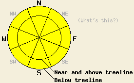
Early this morning, avalanche danger is LOW for all elevations and aspects. Widespread MODERATE avalanche danger will form today at all elevations and on all aspects in response to daytime warming. The vast majority of any avalanche activity that occurs today is expected to be human triggered. An isolated natural avalanche occurrence is unlikely, but not outside the realm of possibility during the late afternoon hours. |
|
|
|
High pressure continues to build over the forecast area. Sunny skies with some cumulus cloud build up is expected for today. Remote sensors above 8,000' are reporting air temperatures in the low to mid 30s this morning. Maximum daytime air temperatures above 7,000' are forecast to reach the upper 40s to upper 50s today. Light northeast winds will continue today. Air temperatures are forecast to drop to near or below freezing again tonight for most locations. Sunny to partly cloudy skies with daytime highs in the low 50s to low 60s and light winds are forecast for tomorrow.
Observations made yesterday on Rubicon Peak (West Shore Tahoe area) revealed new snow amounts ranged from a trace at 7,000' to 5 inches at 9,000'. Wind loaded areas above 8,500' held up to 12 inches of new snow. Wet snow existed below the melt freeze crust at the base of the new snow in all areas. No evidence of instability was observed within the new snow during the morning hours, but rapid warming and strong incoming solar radiation was starting to affect the surface snow on N-NE-E aspects by 11 am. Small skier triggered roller balls occurred at that time. Melting and free water formation at the snow surface by mid day indicated that additional daytime warming during the afternoon hours was likely to create areas of instability on all aspects. Significant depletion of the snowpack has occurred below 7,500' in this area over the past week due to warm air temperatures and rain (video, pit profile, more info).
Today's Primary Avalanche Concern: Wet snow instability
An overnight refreeze of at least the top few inches of surface snow is expected to have occurred last night. Snow surface conditions ranging by elevation and aspect from supportable to breakable melt freeze crust are expected early this morning. As the day progresses, widespread wet snow conditions are expected to form. In areas above 8,000' where the recent new snow has not yet transitioned to melt freeze snow, human triggered roller balls, wet loose snow avalanches, and shallow wet slab avalanches remain possible today. An isolated natural avalanche event is unlikely, but not out of the realm of possibility. In areas where the recent new snow has fully assimilated with the old melt freeze snow below, wet snow instability will remain limited to human triggered roller balls and wet loose snow avalanches.
Other things to think about: The Persistent Weak Layer
Over the past week, free water has percolated anywhere from a few feet deep to full height through the snowpack. While deep wet slab avalanches remain a theoretical concern on NW-N-NE aspects, so far none have occurred. Limited recent observations on the deeply buried persistent weak layer indicate that where free water has reached the depth of the weak layer it did not trigger failure of this layer, but was able to percolate through it and destroy it. Given the variability of this weak layer and the uneven depth of free water percolation across the forecast area, deep wet slab avalanches remain an ongoing concern. Unlike dry snow avalanches, deep wet slab avalanches are notoriously difficult to predict and are poorly understood from a research standpoint. Due to an insurmountable lack of information, naturally occurring deep wet slab avalanches cannot be ruled out nor can the most likely timing of occurrence be pinpointed.
Early this morning, avalanche danger is LOW for all elevations and aspects. Widespread MODERATE avalanche danger will form today at all elevations and on all aspects in response to daytime warming. The vast majority of any avalanche activity that occurs today is expected to be human triggered. An isolated natural avalanche occurrence is unlikely, but not outside the realm of possibility during the late afternoon hours.
| 0600 temperature: | 30 to 35 deg. F. |
| Max. temperature in the last 24 hours: | 37 to 52 deg. F. |
| Average wind direction during the last 24 hours: | Northeast |
| Average wind speed during the last 24 hours: | 6 mph |
| Maximum wind gust in the last 24 hours: | 20 mph |
| New snowfall in the last 24 hours: | O inches |
| Total snow depth: | 19 to 74 inches |
For 7000-8000 ft: |
|||
| Saturday: | Saturday Night: | Sunday: | |
| Weather: | Sunny skies becoming partly cloudy. | Clear skies. | Sunny skies, becoming partly cloudy. |
| Temperatures: | 53 to 59 deg. F. | 28 to 35 deg. F. | 56 to 62 deg. F. |
| Wind direction: | NE | Variable | Variable |
| Wind speed: | 10 to 15 mph in the morning, becoming light. | Light winds | Light winds |
| Expected snowfall: | O in. | O in. | O in. |
For 8000-9000 ft: |
|||
| Saturday: | Saturday Night: | Sunday: | |
| Weather: | Sunny skies becoming partly cloudy. | Clear skies. | Sunny skies becoming partly cloudy. |
| Temperatures: | 48 to 54 deg. F. | 27 to 34 deg. F. | 51 to 57 deg. F. |
| Wind direction: | NE | NE | Variable |
| Wind speed: | 15 to 20 mph with gusts to 35 mph. | 10 to 15 mph. | Light winds |
| Expected snowfall: | O in. | O in. | O in. |


This website is owned and maintained by the non-profit arm of the Sierra Avalanche Center. Some of the content is updated by the USDA avalanche forecasters including the forecasts and some observational data. The USDA is not responsible for any advertising, fund-raising events/information, or sponsorship information, or other content not related to the forecasts and the data pertaining to the forecasts.

