In partnership with: 
|
November 17, 2012 at 7:04 am |
|
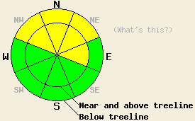
Rain on snow, strong winds, and new snowfall will create areas of MODERATE avalanche danger on both above and below treeline NW-N-NE-E aspects on slopes 35 degrees and steeper. For all other areas, avalanche danger remains LOW. |
|
|
|
Since precipitation started yesterday .3 to .6 inches of water has fallen around the forecast area. Snow levels have remained between 7500 ft. and 8000 ft allowing most of this precipitation to fall as rain below 8000 ft. Remote sensors show that 2 to 4 inches of wet heavy snow has accumulated above 8000 ft across the forecast area. Showery precipitation should continue today with another 2 to 5 inches of snow predicted above 7500 ft. The forecast calls for snow levels to remain high (between 7500 ft and 8000 ft.) until a cold front arrives later this evening. Once that front reaches the forecast area, snow levels should start fall and snowfall intensity should increase. Tonight snow levels could push down to around 6500 ft allowing 4 to 8 inches of additional snow accumulation. By tomorrow this storm system should begin to move away from the region causing the snow to taper showers along the Sierra Crest. The southwest winds started to increase yesterday and should remain strong through tomorrow with average speeds in the 35 to 60 mph range and gusts up to 90 mph today and tonight along the Sierra Crest.
Yesterday observations near Elephant's Back on Carson Pass, Mt. Judah on Donner Summit, and on Tamarack Peak in the Mt. Rose backcountry showed a shallow and variable snowpack. The higher elevation northerly aspects have the most snow, while bare ground, rocks, shrubbery, and stumps still remain visible on most of the lower elevations and other aspects. Snowpit tests, ski cuts, and other observations in these areas showed a mostly consolidated snowpack with a thick crust in the middle of the pack. On Mt. Judah and in the Carson Pass area below 8000 ft. light rain had started to fall on the snowpack in the morning. Above 8000 ft heavy wet snow started to accumulate on top of the existing snowpack. Weak sugary snow (facets) did exist on some of the northerly aspects in the Tamarack Peak area.
Today's Primary Avalanche Concern: Wind Slabs
Strong southwest winds and new snow have allowed some wind slabs to build on wind-loaded and cross-loaded aspects. So far these wind slabs should have remained relatively small due to the small amounts of new snow. As more snow and wind continue to impact the forecast area today and tonight, expect these wind slabs to become thicker and to expand in size. By this evening wind slabs more than 2-3 ft deep could exist in wind loaded areas. The largest and most fragile wind slabs will form on open near and above treeline terrain on N-NE-E aspects. These areas also had the most coverage before this storm meaning that the anchors holding the snowpack in place may have already been buried and will not help hold the wind slabs in place. Human triggering of these wind slabs will be possible today.
Today's Secondary Avalanche Concern: Wet Snow Instabilities
Continued rain on snow may cause some wet snow instabilities today on NW-N-NE aspects below 8,000 ft where soft unconsolidated snow existed on the surface prior to this storm. Areas of both human triggered and naturally occurring wet loose snow avalanches and roller balls will be possible today. Any of these avalanches that occur should remain small and not involve enough snow to bury a person unless a terrain trap is involved.
Rain on snow, strong winds, and new snowfall will create areas of MODERATE avalanche danger on both above and below treeline NW-N-NE-E aspects on slopes 35 degrees and steeper. For all other areas, avalanche danger remains LOW.
| 0600 temperature: | 29-32 deg. F. |
| Max. temperature in the last 24 hours: | 30-35 deg. F. |
| Average wind direction during the last 24 hours: | Southwest |
| Average wind speed during the last 24 hours: | 25-30 mph |
| Maximum wind gust in the last 24 hours: | 52 mph |
| New snowfall in the last 24 hours: | Below 8000 ft mostly rain. Above 8000 ft up to 4 inches |
| Total snow depth: | 6-36 inches |
For 7000-8000 ft: |
|||
| Saturday: | Saturday Night: | Sunday: | |
| Weather: | Cloudy with a mix of rain and snow. Snow levels between 7500 ft and 8000 ft. | Cloudy with a mix of rain and snow in the evening becoming snow by midnight. | Snow tapering to snow showers by late morning. |
| Temperatures: | 33-39 deg. F. | 25-30 deg. F. | 30-35 deg. F. |
| Wind direction: | Southwest | Southwest | Southwest |
| Wind speed: | 20-35 mph with gusts to 50 mph | 25-40 mph with gusts to 60 mph | 20-30 mph with gusts to 55 mph |
| Expected snowfall: | 2-5 in. above 7500 ft. Below 7500 ft mostly rain in. | 4-8 in. | 2-4 in. |
For 8000-9000 ft: |
|||
| Saturday: | Saturday Night: | Sunday: | |
| Weather: | Cloudy with snow showers. | Snow. | Snow tapering to snow showers by late morning. |
| Temperatures: | 30-35 deg. F. | 20-25 deg. F. | 25-30 deg. F. |
| Wind direction: | Southwest | Southwest | Southwest |
| Wind speed: | 40-55 mph with gusts to 90 mph | 45-60 mph with gusts to 90 mph | 35-50 mph with gusts to 75 mph |
| Expected snowfall: | 2-5 in. | 4-8 in. | 2-4 in. |


This website is owned and maintained by the non-profit arm of the Sierra Avalanche Center. Some of the content is updated by the USDA avalanche forecasters including the forecasts and some observational data. The USDA is not responsible for any advertising, fund-raising events/information, or sponsorship information, or other content not related to the forecasts and the data pertaining to the forecasts.

