In partnership with: 
|
November 19, 2012 at 7:40 am |
|
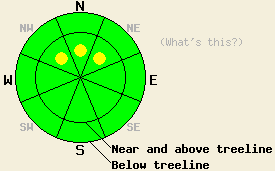
Near and above treeline, lingering pockets of MODERATE avalanche danger exist on NW-N-NE aspects on slope 35 degrees and steeper. For all other areas, avalanche danger is LOW. |
|
|
|
Snow levels held around 7,000' during the day yesterday and allowed for an additional 1 to 3 inches of new snow accumulation on top of the 6 to 12 inches that accumulated above 7,500' Sunday night. A break in the precipitation will occur today. Storm systems continuing to move onshore to the north of the forecast area will keep cloud cover and moderate to strong southwest ridgetop winds in place today and tomorrow. By Tuesday night, another round of light precipitation is expected to impact the forecast area. For today, expect air temperatures in the mid 30s to mid 40s at most elevations. Southwest ridgetop winds remain moderate in speed this morning and will gradually increase in speed this afternoon, tonight, and tomorrow.
Wind loading was observed just below ridgelines yesterday in the Donner Summit, Echo Summit, and Carson Pass areas. A skier triggered avalanche occurred yesterday afternoon in the Carson Pass area, just to the south of Red Lake at around 8,900' on a NW aspect 35 degree slope in near treeline terrain. The wind slab was directly triggered by the skier on the second turn into the slope. The slab was approximately 1 foot deep and 30 feet wide. The avalanche ran down a gully feature for around 300 vertical feet. The snowpack was noted to fail just above a crust at the bottom of the recent new snow (photos, more info).
Observations made yesterday on Andesite Peak (Donner Summit area) and on Becker Peak (Echo Summit area) did not reveal any significant signs of snowpack instability beyond the presence of new snow and wind loading (more info). The recent new snow sits on top of a variety of old snow surfaces consisting of rain crust below 8,300' and possibly as high as 9,000', melt-freeze crust up to as high as 9,000', and old faceted snow in isolated areas above 9,500'.
Today's Primary Avalanche Concern: Wind Slabs
Natural avalanches are unlikely today while human triggered avalanches remain possible. Recently wind loaded areas may hold pockets of lingering snowpack instability today, mainly near and above treeline on NW-N-NE aspects. In these areas, dense wind slabs ranging from 1 to 2 feet deep sit on top of either rain crust, melt-freeze crust, or faceted old snow depending on elevation. While overall the snowpack remains shallow, there is enough snow in areas that typically receive wind loading to cover any anchors on the slope and provide a smooth bed surface for an avalanche to run on.
Near and above treeline, lingering pockets of MODERATE avalanche danger exist on NW-N-NE aspects on slope 35 degrees and steeper. For all other areas, avalanche danger is LOW.
| 0600 temperature: | 28 to 30 deg. F. |
| Max. temperature in the last 24 hours: | 29 to 33 deg. F. |
| Average wind direction during the last 24 hours: | Southwest |
| Average wind speed during the last 24 hours: | 40 mph |
| Maximum wind gust in the last 24 hours: | 70 mph |
| New snowfall in the last 24 hours: | 1 to 3 inches |
| Total snow depth: | 17 to 36 inches |
For 7000-8000 ft: |
|||
| Monday: | Monday Night: | Tuesday: | |
| Weather: | Cloudy skies. | Cloudy skies. | Cloudy skies. |
| Temperatures: | 40 to 45 deg. F. | 32 to 35 deg. F. | 42 to 48 deg. F. |
| Wind direction: | SW | SW | SW |
| Wind speed: | 10 to 20 mph with gusts to 35 mph in the afternoon. | 15 to 25 mph with gusts to 45 mph. | 25 to 35 mph with gusts to 50 mph. |
| Expected snowfall: | O in. | O in. | O in. |
For 8000-9000 ft: |
|||
| Monday: | Monday Night: | Tuesday: | |
| Weather: | Cloudy skies. | Cloudy skies. | Cloudy skies. |
| Temperatures: | 34 to 41 deg. F. | 31 to 44 deg. F. | 39 to 43 deg. F. |
| Wind direction: | SW | SW | SW |
| Wind speed: | 20 to 25 mph with gusts to 40 mph, increasing to 30 to 35 mph with gusts to 50 mph in the afternoon. | 30 to 40 mph with gusts to 60 mph. | 40 to 45 mph with gusts to 65 mph, increasing to 50 to 55 mph with gusts to 80 mph in the afternoon. |
| Expected snowfall: | O in. | O in. | O in. |


This website is owned and maintained by the non-profit arm of the Sierra Avalanche Center. Some of the content is updated by the USDA avalanche forecasters including the forecasts and some observational data. The USDA is not responsible for any advertising, fund-raising events/information, or sponsorship information, or other content not related to the forecasts and the data pertaining to the forecasts.

