In partnership with: 
|
November 24, 2012 at 7:17 am |
|
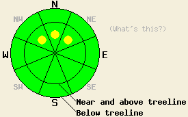
For most of the area the avalanche danger remains LOW. A few small isolated pockets of MODERATE avalanche danger may still exist on near and above treeline NW-N-NE aspects steeper than 35 degrees. LOW danger does not mean no danger. |
|
|
|
The clear and relatively calm night has allowed cold air to settle into the valleys setting up a temperature inversion this morning similar to yesterday. Remote sensors below 7000 ft. show temperatures in the upper 20's and low 30's while the sensors at the higher elevations indicate temperatures in the low 40's this morning. The weather should remain spring-like today with sunny skies and temperatures in the the upper 40's to upper 50's above 7000 ft. The forecast calls for a weak cold front to arrive over the region tonight bringing cooler temperatures and few clouds with it. Sunny skies should return tomorrow with slightly cooler daytime highs. The southwest wind have started increase and should remain moderate through tomorrow.
Observations on Round Top and on Rubicon yesterday both showed a spring-like snowpack consisting of consolidated snow and crusts. In both of these areas, the snow surface stayed frozen and supportable on the northerly aspects with only a few areas softening due to daytime warming. Most of the data in these areas pointed to a stable snowpack except for some snowpit tests on Round Top that revealed a softer layer of snow about 1.5 ft down. These tests showed that fractures could still propagate through this layer (snowpit). On Rubicon numerous anchors remain uncovered at all elevations. Below 7500 ft. on Rubicon only a few patches of snow remain.
Earlier in the week observations at higher elevations in the Mt. Rose backcountry show more consistent snow coverage; however, a persistent weak layer of soft sugary snow (facets) exists below a cohesive slab in some areas. Snowpits have shown this layer on N to NE aspects mainly above 9,500 ft. In snowpit tests, this facet layer collapsed easily and propagated cleanly, (videos, more info). This layer appears weakest on slopes that received little to no traffic prior to the most recent snowfall.
Today's Primary Avalanche Concern: Persistent Slabs
Although they have become more difficult to trigger, human triggered avalanches will remain possible in isolated areas where cohesive snow rests on top a persistent weak layer. So far this combination has only been seen in small areas in the Mt. Rose backcountry on NW-N-NE aspects above 9500 ft. Variability associated with the existence, location, strength, and coverage of both the persistent weak layer and the slab above it make this problem difficult to track and evaluate. Snowpack failure resulting from this kind of avalanche concern could occur on slopes where several people have already tested the slope on skis, boards, or sleds but have not found the right trigger point to cause a larger failure. Probing into the snowpack and digging quick snowpits can reveal whether or not this combination exists on a particular slope.
Other things to think about:
Even though LOW avalanche danger exists around most of the forecast area, this does not mean no danger remains. Some unstable snow may still exist on isolated terrain features especially in complex or extreme terrain. Also, the shallow early season snowpack means more exposed stumps, rocks, trees, and other very hard objects that tend to "win" when they collide with backcountry recreationalists.
For most of the area the avalanche danger remains LOW. A few small isolated pockets of MODERATE avalanche danger may still exist on near and above treeline NW-N-NE aspects steeper than 35 degrees. LOW danger does not mean no danger.
| 0600 temperature: | 39-42 deg. F. |
| Max. temperature in the last 24 hours: | 46-56 deg. F. |
| Average wind direction during the last 24 hours: | Southwest |
| Average wind speed during the last 24 hours: | 15-25 mph |
| Maximum wind gust in the last 24 hours: | 35 mph |
| New snowfall in the last 24 hours: | O inches |
| Total snow depth: | 12-29 inches |
For 7000-8000 ft: |
|||
| Saturday: | Saturday Night: | Sunday: | |
| Weather: | Sunny | Clear becoming partly cloudy | Sunny |
| Temperatures: | 51-57 deg. F. | 29-35 deg. F. | 40-47 deg. F. |
| Wind direction: | Southwest | Southwest | Southwest |
| Wind speed: | 10-15 mph | 10-15 mph with gusts to 25 mph after midnight | 10-15 mph with gusts to 25 mph |
| Expected snowfall: | O in. | O in. | O in. |
For 8000-9000 ft: |
|||
| Saturday: | Saturday Night: | Sunday: | |
| Weather: | Sunny | Clear becoming partly cloudy | Sunny |
| Temperatures: | 47-53 deg. F. | 24-31 deg. F. | 34-41 deg. F. |
| Wind direction: | Southwest | West | West |
| Wind speed: | 15-25 mph with gusts to 35 mph | 15-25 mph with gusts to 35 mph | 15-25 mph with gusts to 35 mph |
| Expected snowfall: | O in. | O in. | O in. |


This website is owned and maintained by the non-profit arm of the Sierra Avalanche Center. Some of the content is updated by the USDA avalanche forecasters including the forecasts and some observational data. The USDA is not responsible for any advertising, fund-raising events/information, or sponsorship information, or other content not related to the forecasts and the data pertaining to the forecasts.

