In partnership with: 
|
November 27, 2012 at 7:45 am |
|
Avalanche danger is LOW for all elevations and aspects. Very isolated areas of unstable snow may exist above 9,000' on NW-N-NE aspects in complex or extreme terrain. |
|
|
|
Transitional weather is in store for today ahead of a prolonged storm cycle beginning tomorrow and lasting into next week. For the next 24 hours expect increasing clouds and increasing winds before precipitation begins on Wednesday. Air temperatures this morning are in the low 30s to low 40s for areas above 6,800'. An air temperature inversion has colder air on the mountain valley floors below 6,500'. Air temperatures are forecast to warm into the 40s today for nearly all areas. Over the next several days, expect periods of gale force winds and high intensity precipitation. Snow levels are currently forecast to begin around 6,500' to 7,500' and then rise to 7,500' to 8,500'.
Observations made yesterday in the Miess drainage (Carson Pass area) revealed widespread supportable rain crust and melt freeze crust on all aspects and at all elevations. Snowpit data collected above treeline on a NE aspect at 9,200' gave indications of ongoing snowpack instability in the upper portion of the snowpack. Over the past 10 days, persistent weakness has been noted on a lower density layer of faceted snow crystals that sits just below a buried rain crust generally 6 to 16 inches below the snow surface (pit profile, more info). It is currently an unlikely scenario for a person on skis or a snowmobile to trigger failure on this layer. It is something to keep an eye on as significant new snow loading later this week for areas above 9,000' could increase the likelihood of snowpack failure occurring on this layer.
Observations made Sunday on Silver Peak (Pole Creek area) and on Castle Peak (Donner Summit area) both revealed a stable snowpack in the 7,500' to 8,500' elevation range. Firm and supportable melt-freeze crust existed on all aspects up to at least 8,300' and significantly higher in more sun exposed areas (photos, pit profiles, more info). The existing snowpack gains usable depth above 7,500' where it is generally 1 to 3 feet deep. Isolated areas of deeper snow have been observed in previously wind loaded areas near ridgelines.
Other recent observations from the Mount Rose area have given indications of isolated pockets of persistent snowpack instability. These pockets have been observed above 9,500' on NW-N-NE aspects. A layer of basal facets has shown persistent instability in snowpit tests in these areas. This layer appears weakest on isolated northerly aspects above 9,500' that received little to no traffic prior to burial of this layer on November 16th (photos, videos, pit profiles, more info).
Today's Avalanche Concerns:
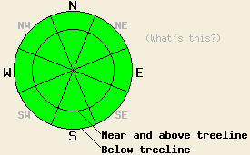
Avalanche concerns at this time are limited to isolated areas above 9,000' on NW-N-NE aspects where some form of ongoing instability has been observed in recent days. At this time, avalanches are difficult to trigger with the only evidence of slope specific snowpack instability available from snowpit data. Any areas of instability that are encountered will exist within greater surrounding areas of stable snow. Use of accepted backcountry travel techniques will help to minimize risk.
Avalanche danger is LOW for all elevations and aspects. Very isolated areas of unstable snow may exist above 9,000' on NW-N-NE aspects in complex or extreme terrain.
| 0600 temperature: | 35 to 39 deg. F. |
| Max. temperature in the last 24 hours: | 44 to 50 deg. F. |
| Average wind direction during the last 24 hours: | Southwest |
| Average wind speed during the last 24 hours: | 23 mph |
| Maximum wind gust in the last 24 hours: | 42 mph |
| New snowfall in the last 24 hours: | O inches |
| Total snow depth: | 15 to 28 inches |
For 7000-8000 ft: |
|||
| Tuesday: | Tuesday Night: | Wednesday: | |
| Weather: | Partly cloudy skies. | Mostly cloudy skies. | Cloudy skies with rain and snow. Snow level 6,500' to 7,500'. |
| Temperatures: | 42 to 49 deg. F. | 30 to 36 deg. F. | 33 to 40 deg. F. |
| Wind direction: | SW | S | S |
| Wind speed: | 15 to 25 mph with gusts to 30 mph. Gusts increasing to 40 mph in the afternoon. | 20 to 30 mph with gusts to 40 mph. | 30 to 40 mph with gusts to 60 mph. |
| Expected snowfall: | O in. | O in. | Up to 5 in. |
For 8000-9000 ft: |
|||
| Tuesday: | Tuesday Night: | Wednesday: | |
| Weather: | Partly cloudy skies. | Mostly cloudy skies. | Cloudy skies with snow. |
| Temperatures: | 42 to 48 deg. F. | 25 to 32 deg. F. | 28 to 35 deg. F. |
| Wind direction: | SW | S | S |
| Wind speed: | 30 to 40 mph with gusts to 60 mph. | 35 to 45 mph with gusts to 60 mph. Gusts increasing to 70 mph after midnight. | 40 to 50 mph with gusts to 75 mph. Gusts increasing to 95 mph in the afternoon. |
| Expected snowfall: | O in. | O in. | Up to 5 in. |


This website is owned and maintained by the non-profit arm of the Sierra Avalanche Center. Some of the content is updated by the USDA avalanche forecasters including the forecasts and some observational data. The USDA is not responsible for any advertising, fund-raising events/information, or sponsorship information, or other content not related to the forecasts and the data pertaining to the forecasts.

