In partnership with: 
|
December 1, 2012 at 8:02 am |
|
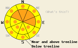
Both above and below treeline, areas of CONSIDERABLE avalanche danger will exist today due to new snow loading and wind loading. Danger will be greatest above 8,000' on NW-N-NE-E aspects steeper than 35 degrees. Widespread HIGH avalanche danger is expected to occur tonight into Sunday due to rain on new snow up to 10,000'. |
|
|
|
The last in this series of powerful storm systems will move into the forecast area today and last through Sunday. Ridgetop winds are increasing this morning ahead of the approaching system. Ongoing gale force/hurricane force winds are expected through Sunday with ridgetop gusts 100 to 130 mph. New snow amounts from the last 24 hours are running 17 to 27 inches above 8,000' and 4 to 6 inches between 7,500' and 8,000'. Below 7,500' has been mostly rain with short periods of accumulating snow that has quickly melted. Snow level will gradually rise today, fluctuating between 7,500' and 8,000' this morning and between 8,000' and 8,500' this afternoon. Snow level is forecast to rise to near 10,000' tonight. The highest elevation peaks within the forecast area could pick up an additional 12 to 18 inches of new snow over the next 24 hours. Nearly all areas will receive significant rainfall on the order of 3 to 4.5 inches.
Observations made yesterday on Rubicon Peak (West Shore Tahoe area) and on Tamarack Peak (Mount Rose area) showed little in the way of snowpack instability despite significant amounts of new snow, snowfall rates around 2 inches per hour, and wind loading (pit profile, photos, video). This was in stark contrast to the day before where significant instability was observed in the form of unstable snowpit test results on the Mt. Judah (Donner summit area) and avalanche activity on Miess Ridge (Carson Pass area). On Mt. Judah, instability was observed on a grauple layer near the base of the new snow. On Miess Ridge a small wind slab avalanche was observed above treeline on a NE aspect at about 9,000'. On northerly aspects, additional instability was observed near the base of the new snow and on a buried layer of faceted snow crystals near crust layers less than 1 foot below the old/new snow interface (pit profile, video, and photo).
Today's Primary Avalanche Concern: Rain on new snow
Rising snow levels today and tonight have the potential to create a widespread rain on snow avalanche cycle for areas above 8,000'. Rain this morning in the 7,500' to 8,000' could create some small loose wet snow avalanches in steep terrain, but the real concern begins this afternoon as snow levels rise above 8,000'. This is where significant amounts of new snow will have fallen over the prior 36 hours. As snow level continues to climb overnight tonight and rain amounts of 3 to 4.5 inches (loading equivalent of 3 to 6 feet of snow) are added to the snowpack below 9,500' to 10,000' over a 12 hour time period. This is the time when avalanche danger will be at it's peak. Naturally occurring slab avalanches are likely during this time. These avalanches could occur in any areas that have received recent new snow and hold a snowpack deeper than 1 to 2 feet. Many areas around 9,000' will have received storm cycle new snow amounts of 3 to 4 feet prior to the onset of rain on snow at that elevation. Upper elevation avalanches could be large and destructive.
Today's Secondary Avalanche Concern: Wind Slabs
Continued snowfall and gale force winds today will continue to build wind slabs, mainly near and above treeline on wind loaded NW-N-NE-E aspects. Rising snow levels will place higher density snow on top of relatively lower density snow which could further add to instability. On northerly aspects above 9,000', the potential remains for triggered wind slab avalanches to step down to layers of faceted snow 1 to 2 feet below the old/new snow interface.
Both above and below treeline, areas of CONSIDERABLE avalanche danger will exist today due to new snow loading and wind loading. Danger will be greatest above 8,000' on NW-N-NE-E aspects steeper than 35 degrees. Widespread HIGH avalanche danger is expected to occur tonight into Sunday due to rain on new snow up to 10,000'.
| 0600 temperature: | 31 to 32 deg. F. |
| Max. temperature in the last 24 hours: | 33 to 34 deg. F. |
| Average wind direction during the last 24 hours: | Southwest |
| Average wind speed during the last 24 hours: | 57 mph |
| Maximum wind gust in the last 24 hours: | 95 mph |
| New snowfall in the last 24 hours: | 17 to 27 inches |
| Total snow depth: | 38 to 52 inches |
For 7000-8000 ft: |
|||
| Saturday: | Saturday Night: | Sunday: | |
| Weather: | Cloudy skies with rain and snow. Snow level fluctuating between 7,500' and 8,000' in the morning, rising to 8,000' to 8,500' in the afternoon. | Cloudy skies with rain and snow in the evening, becoming all rain after 11 pm. Snow level rising above 9,000'. | Cloudy skies with rain in the morning and snow in the afternoon. Snow level lowering to near 6,000' late afternoon/evening. |
| Temperatures: | 33 to 40 deg. F. | 31 to 38 deg. F. | 33 to 40 deg. F. |
| Wind direction: | SW | SW | SW |
| Wind speed: | 45 to 60 mph with gusts to 90 mph, decreasing to 35 to 50 mph with gusts to 80 mph in the afternoon. | 45 to 60 mph with gusts to 90 mph, increasing to 55 to 70 mph with gusts to 105 mph. | 60 to 75 mph with gusts to 115 mph. |
| Expected snowfall: | Up to 4 in. | In the evening, up to 2 in. | 4 to 10 in. |
For 8000-9000 ft: |
|||
| Saturday: | Saturday Night: | Sunday: | |
| Weather: | Cloudy skies with snow through the day, mixing with rain in the afternoon. Snow level rising to 8,000' to 8,500' in the afternoon. | Cloudy skies with rain and snow. Snow level rising above 9,000' | Cloudy skies with rain and snow in the morning, becoming all snow after 1pm. Snow level 9,000'+ falling below 8,000' after 1pm. |
| Temperatures: | 29 to 36 deg. F. | 27 to 34 deg. F. | 30 to 37 deg. F. |
| Wind direction: | SW | SW | SW |
| Wind speed: | 65 to 80 mph with gusts to 130 mph, decreasing to 50 to 65 mph with gusts to 100 mph in the afternoon. | 55 to 65 mph with gusts to 95 mph, increasing to 65 to 75 mph with gusts to 125 mph. | 65 to 85 mph with gusts to 130 mph. |
| Expected snowfall: | Up to 6 in. | In the evening at the highest elevations, 6 to 12 in. | At the highest elevations, 12 to 24 in. |


This website is owned and maintained by the non-profit arm of the Sierra Avalanche Center. Some of the content is updated by the USDA avalanche forecasters including the forecasts and some observational data. The USDA is not responsible for any advertising, fund-raising events/information, or sponsorship information, or other content not related to the forecasts and the data pertaining to the forecasts.

