In partnership with: 
|
December 4, 2012 at 8:00 am |
|
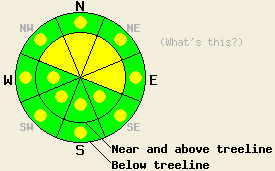
Near and above treeline, avalanche danger remains MODERATE on NW-N-NE-E aspects on slopes steeper than 35 degrees due to lingering wind slabs and rain on snow today and tonight. For all other areas, avalanche danger is LOW with pockets of MODERATE danger on snow-covered slopes steeper than 35 degrees that receive rain today. Expect the avalanche danger to increase as more rain, snow, and wind impact the forecast area tonight and tomorrow. |
|
|
|
Light rain and snow showers should begin over the mountains today as another warm low pressure system approaches the forecast area. The forecast only calls for about .1 inches of precip today. Most of this precipitation should fall as rain below 9000 ft. The main system should move into the region tonight bringing more precipitation, increased southwest winds, and continued warm temperatures. The winds should remain in the 30-40 mph range with gusts as high as 70 mph. The forecast calls for snow levels to remain around 9000 ft until tomorrow when they could drop to around 8500 ft. By tomorrow another 1-1.5 inches of precipitation could have fallen on the forecast area as a mix of rain and high elevation snow.
Data collected yesterday on Red Lake Peak, near Grouse Rocks, and on Tamarack Peak indicated a mostly stable snowpack with a few lingering areas of instability due to fragile wind slabs and poor bonding between the snow that fell at the end of the storm and a rain crust below it. On the eastern side of Tamarack Peak, a very small skier-triggered avalanche occurred resulting from the failure of one of these small wind slabs (more info). Tender cornices also still existed on Tamarack Peak. On Red Lake Peak, snowpit tests where the shallow wind slabs existed still showed that fractures could occur at the base of the winds slabs (snowpit). Ski cuts in steeper less wind affected terrain in the Grouse Rocks area resulted in ski width wide sluffs that entrained the 4-6 inches of snow that remained above a refreezing rain crust (photo). In all of these areas, the majority of observations showed settlement and consolidation in the snowpack (photos of settlement cracks near Grouse Rocks and on Red Lake Peak, stable snowpit results on Tamarack). Deeper in the snowpack snowpits on Red Lake Peak and in the Grouse Rocks area showed a mix of crusts, wet snow that continues to freeze, and consolidated snow.
Today's Primary Avalanche Concern: Rain on Snow
Light rain falling on the recent snow that sits on the surface will add weight to the snowpack and could weaken the strong surface slabs that exist in some areas. It will also add warmth to the snowpack and cause the refreezing process occurring within the snowpack to slow down or even stop in places. These effects will allow wet snow avalanches become possible today. Most of these types avalanches should manifest as loose snow sluffs, roller balls, and pinwheels; however, some wet slab avalanches could occur on the slopes that receive rain where more snow exists.
Today's Secondary Avalanche Concern: Wind Slabs
Wind slabs remaining on wind loaded near and above treeline slopes could still pose a problem today. Many of these winds slabs should remain stubborn and difficult to trigger. However, if rain falls on these wind slabs avalanches involving these wind slabs could become easier to trigger. The NW-N-NE-E aspects in near and above treeline terrain will represent the most likely places to find this instability. Human triggered avalanches large enough to bury or injure a person remain possible.
Near and above treeline, avalanche danger remains MODERATE on NW-N-NE-E aspects on slopes steeper than 35 degrees due to lingering wind slabs and rain on snow today and tonight. For all other areas, avalanche danger is LOW with pockets of MODERATE danger on snow-covered slopes steeper than 35 degrees that receive rain today. Expect the avalanche danger to increase as more rain, snow, and wind impact the forecast area tonight and tomorrow.
| 0600 temperature: | 26-36 deg. F. |
| Max. temperature in the last 24 hours: | 31-39 deg. F. |
| Average wind direction during the last 24 hours: | Southwest |
| Average wind speed during the last 24 hours: | 30-40 mph |
| Maximum wind gust in the last 24 hours: | 60 mph |
| New snowfall in the last 24 hours: | O inches |
| Total snow depth: | 39-58 inches |
For 7000-8000 ft: |
|||
| Tuesday: | Tuesday Night: | Wednesday: | |
| Weather: | Chance of rain and snow in the morning turning to rain in the afternoon. Snow level rising to near 9000 ft. | Cloudy with rain especially after midnight. | Rain |
| Temperatures: | 39-46 deg. F. | 30-37 deg. F. | 35-42 deg. F. |
| Wind direction: | Southwest | Southwest | Southwest |
| Wind speed: | 25-35 mph with gusts up to 50 mph | 25-35 mph with gusts to 50 mph | 20-30 mph with gusts to 45 mph |
| Expected snowfall: | rain up to .1 in. | rain - around .4 in. | rain - around .7 in. |
For 8000-9000 ft: |
|||
| Tuesday: | Tuesday Night: | Wednesday: | |
| Weather: | Chance of rain and snow through the day. Snow level rising to near 9000 ft. | Rain and snow likely. Snow level near 9000 ft. | Rain and snow. Snow level near 8500 ft. |
| Temperatures: | 39-45 deg. F. | 27-34 deg. F. | 34-40 deg. F. |
| Wind direction: | Southwest | Southwest | West |
| Wind speed: | 35-45 mph with gusts between 65-70 mph decreasing to 55-60 mph in the afternoon | 35-45 mph with gusts 60-70 mph | 25-35 mph with gusts 45-55 mph |
| Expected snowfall: | up to 1 in. | up to 2 in. | 3-7 in. |


This website is owned and maintained by the non-profit arm of the Sierra Avalanche Center. Some of the content is updated by the USDA avalanche forecasters including the forecasts and some observational data. The USDA is not responsible for any advertising, fund-raising events/information, or sponsorship information, or other content not related to the forecasts and the data pertaining to the forecasts.

