In partnership with: 
|
December 9, 2012 at 7:46 am |
|
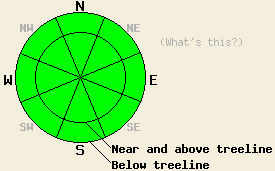
Avalanche danger remains LOW for all elevations and aspects. Normal caution is advised. A long, unarrested, sliding fall down icy slopes leading to impact with trees or rocks is likely the greatest hazard in the backcountry today. |
|
|
|
Observations made yesterday on Becker Peak (Echo Summit area) and on Castle Peak (Donner Summit area) revealed the continued theme of firm crusts on all aspects with some softening on southerly aspects during the mid day and early afternoon hours. The melting snow surface on southerly aspects produced 1 to 3 inches of corn snow with continued supportable snow surface conditions through the afternoon hours. This matched well with other recent observations from around the forecast area over the past three days. Supportable rain crust exists on all aspects below 9,200' and extends to above 10,000' in some areas. The rain wetted layers that existed deeper in the snowpack have now refrozen. Near crust faceting is occurring between the top two rain crusts in the snowpack. The degree to which this has occurred is highly variable around the forecast area with more development observed in the Mount Rose and Echo Summit areas and less development in the Donner Summit area (photos, pit profiles, more info).
Avalanche Concerns:
A frozen icy snowpack that has displayed a widespread lack of instability, combined with minimal solar radiation at this time of year will keep avalanche activity unlikely today. A short window of snow surface melting is expected today on southerly aspects, but not enough to cause any concerns for wet loose or wet slab avalanches. Little to no snow is available for wind transport, so new wind slab formation is unlikely today despite NE winds that are otherwise strong enough to move snow. The faceting that is occurring between the top two rain crusts in the snowpack is not an instability concern for today, but something to keep an eye on as future loading occurs.
Avalanche danger remains LOW for all elevations and aspects. Normal caution is advised. A long, unarrested, sliding fall down icy slopes leading to impact with trees or rocks is likely the greatest hazard in the backcountry today.
| 0600 temperature: | 27 to 32 deg. F. |
| Max. temperature in the last 24 hours: | 37 to 44 deg. F. |
| Average wind direction during the last 24 hours: | NE |
| Average wind speed during the last 24 hours: | 11 mph |
| Maximum wind gust in the last 24 hours: | 37 mph |
| New snowfall in the last 24 hours: | O inches |
| Total snow depth: | 35 to 47 inches |
For 7000-8000 ft: |
|||
| Sunday: | Sunday Night: | Monday: | |
| Weather: | Partly cloudy skies, becoming sunny. | Clear skies. | Sunny skies. |
| Temperatures: | 39 to 43 deg. F. | 29 to 35 deg. F. | 40 to 45 deg. F. |
| Wind direction: | NE | NE shifting to E after midnight. | NE |
| Wind speed: | 20 to 30 mph with gusts to 40 mph. | 20 to 25 mph with gusts to 40 mph, shifting and decreasing to 10 to 15 mph with gusts to 25 mph after midnight. | 10 to 15 mph with gusts to 25 mph. |
| Expected snowfall: | O in. | O in. | O in. |
For 8000-9000 ft: |
|||
| Sunday: | Sunday Night: | Monday: | |
| Weather: | Partly cloudy skies, becoming sunny. | Clear skies. | Sunny skies. |
| Temperatures: | 35 to 40 deg. F. | 29 to 34 deg. F. | 36 to 42 deg. F. |
| Wind direction: | NE | NE | NE |
| Wind speed: | 35 to 45 mph with gusts to 65 mph. | 35 to 40 mph with gusts to 60 mph, decreasing to 20 to 25 mph with gusts to 40 mph after midnight. | 15 to 25 mph with gusts to 40 mph. |
| Expected snowfall: | O in. | O in. | O in. |


This website is owned and maintained by the non-profit arm of the Sierra Avalanche Center. Some of the content is updated by the USDA avalanche forecasters including the forecasts and some observational data. The USDA is not responsible for any advertising, fund-raising events/information, or sponsorship information, or other content not related to the forecasts and the data pertaining to the forecasts.

