In partnership with: 
|
December 17, 2012 at 8:00 am |
|
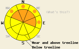
UPDATED AT 9:00am Near and above treeline the avalanche danger is CONSIDERABLE on the NW-N-NE-E aspects on slopes 35 degrees and steeper due to continued wind and new snow. Below treeline, pockets of CONSIDERABLE avalanche danger exist on wind loaded NW-N-NE-E aspects steeper than 35 degrees. Human triggered avalanches will be likely today and natural avalanches will be possible. |
|
|
|
Temperatures have steadily climbed since yesterday morning raising the snow level to between 6700 ft. and 7000 ft. Above 7000 ft. 3-7 inches of new snow has fallen since yesterday afternoon. Snowfall should increase today as another storm moves into the area. The forecast calls for another 5-12 inches of snow above 7000 ft. by tomorrow morning. The most intense snowfall should occur before noon today. The cold front associated with this storm should push snow levels and temperatures down. Tomorrow's daytime highs should only reach into the teens above 7000 ft. The gale force southwest winds that began yesterday afternoon will continue today. Expect wind speeds in the 50-70 mph range with gusts over 100 mph along the Sierra Crest. By tomorrow the winds should have decreased as the storm departs the area.
Yesterday on Becker Peak (near Echo Summit), observations in several locations showed that the Dec. 2nd facet layer exists below a rain crust in this area as well (photo, snowpit and photos). Tests on this layer showed that it remains weak and easy to break. In these tests the resulting fracture did not propagate very far along the weak layer. Ski cuts on tests slopes with small wind slabs on top of this crust/facet combination did not cause any cracking or collapses in the facets or within the new snow. On steeper slopes on northerly aspects, some skier triggered sluffing did occur (more info). A thin breakable crust existed on the snow surface on all aspects in this area yesterday and limited the amount of snow available for wind transport until the winds increased significantly in the afternoon.
9:00 AM update:
Large natural avalanches that occurred early this morning or last night have been reported on Incline Lake Peak (Mt Rose backcountry) and on Wild Flower Ridge (Donner Summit area). The slide on Incline Lake Peak stepped down to the Dec 2nd facet layer. Smaller human triggered avalanches and many skier triggered shooting cracks were also reported on Incline Lake Peak. In both areas strong wind loading continues.
Avalanche Problem #1: Wind Slabs
The gale force winds that occurred last night should continue through today. These winds combined with today's continued accumulation will load more and more snow onto the leeward slopes. Extensive wind slabs several feet deep could easily exist on the wind loaded slopes today. These wind slabs rest on lighter weaker snow. Triggering large wind slab avalanches will be likely today. The largest and most sensitive wind slabs will exist on near and above treeline NW-N-NE-E aspects. Some wind slabs may also form on wind loaded slopes in below treeline terrain due to the strength of the winds.
Avalanche Problem #2: Persistent Slabs
So far the rain crust above the Dec. 2nd facet layer has prevented forces from reaching the weak facet layer and thus prevented avalanche activity from occurring due to the failure of the facets. As more and more snow accumulates above this crust/facet combination and as the crust above the facets continues to weaken, it will become easier for those facets to break. The new snow and wind may have added enough new load on top of the snowpack to allow failure of this layer to occur today. Any avalanches that occur today like the wind slabs mentioned above could also step down into the facet layer resulting in deeper and more dangerous avalanches. The most well developed and weakest facets exist on the NW-N-NE aspects between 7,500 ft. and 10,000 ft.
UPDATED AT 9:00am
Near and above treeline the avalanche danger is CONSIDERABLE on the NW-N-NE-E aspects on slopes 35 degrees and steeper due to continued wind and new snow. Below treeline, pockets of CONSIDERABLE avalanche danger exist on wind loaded NW-N-NE-E aspects steeper than 35 degrees. Human triggered avalanches will be likely today and natural avalanches will be possible.
| 0600 temperature: | 25-30 deg. F. |
| Max. temperature in the last 24 hours: | 25-32 deg. F. |
| Average wind direction during the last 24 hours: | Southwest |
| Average wind speed during the last 24 hours: | East of Lake Tahoe 35 mph | Along the Sierra Crest: 50-60 mph |
| Maximum wind gust in the last 24 hours: | East of Lake Tahoe 64 mph | Along the Sierra Crest: 113 mph |
| New snowfall in the last 24 hours: | 3-7 inches |
| Total snow depth: | 41-54 inches |
For 7000-8000 ft: |
|||
| Monday: | Monday Night: | Tuesday: | |
| Weather: | Snow | Snow | Mostly cloudy with snow likely |
| Temperatures: | 25-30 deg. F. | 15-20 deg. F. | 15-20 deg. F. |
| Wind direction: | Southwest | Southwest | West |
| Wind speed: | 20-35 mph with gusts to 50 mph | 15-25 mph with gusts to 40 mph decreasing to 10-20 mph with gusts to 30 mph after midnight | 5-15 mph in the morning becoming light in the afternoon |
| Expected snowfall: | 4-8 in. | 1-4 in. | 1-3 in. |
For 8000-9000 ft: |
|||
| Monday: | Monday Night: | Tuesday: | |
| Weather: | Snow | Snow | Mostly cloudy with snow likely |
| Temperatures: | 24-29 deg. F. | 8-15 deg. F. | 8-15 deg. F. |
| Wind direction: | Southwest | Southwest | Northwest |
| Wind speed: | 60-75 mph with gusts to 115 mph decreasing to 50-60 mph with gusts to 80 mph in the afternoon | 40-55 mph with gusts to 80 mph decreasing to 20-35 mph with gusts to 60 mph after midnight | 10-20 mph with gusts to 30 mph |
| Expected snowfall: | 4-8 in. | 1-4 in. | 1-3 in. |


This website is owned and maintained by the non-profit arm of the Sierra Avalanche Center. Some of the content is updated by the USDA avalanche forecasters including the forecasts and some observational data. The USDA is not responsible for any advertising, fund-raising events/information, or sponsorship information, or other content not related to the forecasts and the data pertaining to the forecasts.

