In partnership with: 
|
December 23, 2012 at 8:00 am |
|
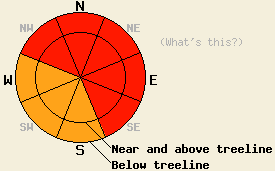
The avalanche danger is HIGH at all elevations on the NW-N-NE-E-SE aspects on slopes steeper than 33 degrees due to wind slabs and heavy snow loads accumulating on an already weak snowpack. Large, destructive human triggered and natural avalanches will be widespread today. Very Dangerous avalanche conditions exist, and travel in or below avalanche terrain is not recommenced. |
|
|
|
Yesterday widespread skier triggered shooting cracks and collapses occurred on Red Lake Peak (photos and more info), Castle Peak (photos and more info), Andesite Ridge (photos and more info), and Tamarack Peak (videos, photos, more info). On Red Lake Peak, Castle Peak, and Andesite Ridge, test slopes failed easily in response to the weight of a skier. Wind slabs existed in typically sheltered areas as well as in the more exposed terrain in these places. Several remotely triggered avalanches involving the wind slabs occurred on SE-E-NE-N aspects on Castle Peak and on Andesite Ridge. The largest of these failed on the density change buried on Dec. 17th. Steep non-wind loaded test slopes in below treeline sheltered terrain also failed on this layer resulting in soft storm slab avalanches. The density change mentioned above, a facet layer on top of the rain crust (the Dec 12th facet layer), and a facet layer below the rain crust (the Dec 2nd facet layer) all failed easily in tests in yesterday. The tests showed that fractures could propagate along any or all three of those layers. Observations around the forecast area prior to this storm showed similar snowpack characteristics. Overall the data indicates a snowpack teetering on the edge of failure.
Avalanche Problem #1: Wind Slabs and Storm Slabs
Fragile wind slabs already exist across the forecast area. These wind slabs exist in below and above treeline terrain and in areas that typically remain sheltered. Additional snow and wind today will continue to add weight and depth to the wind slabs. These wind slabs rest on top of the weak layers mentioned above. Additional weaknesses will form today as warmer temperatures add a more dense layer of snow above yesterday's lighter snow creating an upside-down snowpack. Other variations in snowfall intensity, temperature, winds, and other storm characteristics could also create weaknesses within the new snow. Large, destructive, and widespread natural and human triggered avalanches involving large wind slabs will occur today as the afore mentioned weaknesses fail. The largest and most fragile wind slabs will exist on wind loaded and cross loaded NW-N-NE-E-SE aspects in both above and below treeline terrain. In more protected areas, some softer storm slabs could also exist on top of the already weak snowpack, and failure of these storm slabs will also be likely.
Avalanche Problem #2: Persistent Slabs
The snowfall from this series of storms could add enough load to cause the persistent weak layers (the Dec 12th and the Dec 2 facets mentioned above) now buried deep in the snowpack to fail. Variability in the strength and distribution of these layers means uncertainty remains as to exactly where and when these facet layers will fail, but avalanches resulting from the failure of these layers could become more and more widespread as more weight accumulates on top of the snowpack. The most well developed and weakest facets exist on the NW-N-NE aspects between 7,500 ft. and 10,000 ft. The avalanches that result form the failure of these layers will fracture across wider areas and could easily break above or far to the side of the person who triggers them. Other avalanches could also step down to these deeper weaknesses. Any avalanches that fail on these facet layers will be large and destructive.
The avalanche danger is HIGH at all elevations on the NW-N-NE-E-SE aspects on slopes steeper than 33 degrees due to wind slabs and heavy snow loads accumulating on an already weak snowpack. Large, destructive human triggered and natural avalanches will be widespread today. Very Dangerous avalanche conditions exist, and travel in or below avalanche terrain is not recommenced.
| 0600 temperature: | 18-22 deg. F. |
| Max. temperature in the last 24 hours: | 22-26 deg. F. |
| Average wind direction during the last 24 hours: | Southwest |
| Average wind speed during the last 24 hours: | 35 mph |
| Maximum wind gust in the last 24 hours: | 92 mph |
| New snowfall in the last 24 hours: | 14-24 inches |
| Total snow depth: | 56-90 inches |
For 7000-8000 ft: |
|||
| Sunday: | Sunday Night: | Monday: | |
| Weather: | Snow | Snow in the evening with snow showers decreasing after midnight. | Mostly cloudy with a chance of snow showers in the morning. |
| Temperatures: | 23-29 deg. F. | 18-23 deg. F. | 22-29 deg. F. |
| Wind direction: | Southwest | Southwest | Southwest |
| Wind speed: | 15-30 mph with gusts to 45 mph increasing to 25-40 mph with gusts to 60 mph | 25-40 mph with gusts to 60 mph decreasing to 20-30 mph with gusts to 45 mph after midnight | 20-25 mph with gusts to 40 mph decreasing to 10-15 mph with gusts to 25 mph in the afternoon |
| Expected snowfall: | 6-16 in. | 3-8 in. | O in. |
For 8000-9000 ft: |
|||
| Sunday: | Sunday Night: | Monday: | |
| Weather: | Snow | Snow in the evening with snow showers decreasing after midnight. | Mostly cloudy with a chance of snow showers in the morning. |
| Temperatures: | 21-26 deg. F. | 9-16 deg. F. | 18-25 deg. F. |
| Wind direction: | Southwest | Southwest | Southwest shifting to the west in the afternoon |
| Wind speed: | 40-55 mph with gusts to 85 mph increasing to 60-75 mph with gusts to 115 mph in the afternoon | 60-75 mph with gusts to 105 mph decreasing to 40-50 mph with gusts to 75 mph after midnight | 30-40 mph with gusts to 60 mph decreasing to 20-30 mph with gusts to 45 mph in the afternoon |
| Expected snowfall: | 6-16 in. | 3-9 in. | O in. |


This website is owned and maintained by the non-profit arm of the Sierra Avalanche Center. Some of the content is updated by the USDA avalanche forecasters including the forecasts and some observational data. The USDA is not responsible for any advertising, fund-raising events/information, or sponsorship information, or other content not related to the forecasts and the data pertaining to the forecasts.

