In partnership with: 
|
December 28, 2012 at 8:00 am |
|
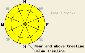
MODERATE avalanche danger exists today both above and below treeline on all aspects on slopes 35 degrees and steeper. A mix of recently formed wind slabs and heavy snow loads sitting on top of weak persistent deep slabs will allow large destructive human triggered avalanches to remain possible. Natural avalanches are unlikely. Adjust travel tactics accordingly to account for the possibility of triggering large long running avalanches from locations low on slopes and from significant distances away. |
|
|
|
Cold temperatures and light winds should persist across the forecast area. A low pressure system off the coast of CA should begin to push more cloud cover into the region today, and the winds should increase some as this system moves down the CA coast. The forecast calls for most of this system to remain west of the forecast area. Due to the more westerly and southerly track of this low, precipitation should remain limited to small amounts of snow near the Sierra Crest. The forecast calls for up to 4 inches of new snow by tomorrow evening. Snow showers should end tomorrow night, and the winds should shift towards the north and east and remain mild.
Yesterday, lingering signs of storm snow instability existed on Silver Peak (more info, snowpit, video), Ralston Peak (more info), and on Donner Summit (more info). In all of these areas, some minor cracking occurred on wind loaded aspects (including those southerly aspects loaded by the recent N winds). Some snowpit tests showed possible instabilities remaining in the recent storm snow layers in these areas. However, ski cuts on multiple above and below treeline test slopes did not cause any failures. Most other observations in these areas as well as on the NE side of Flagpole Peak (more info) indicated that the storm snow continues to settle and consolidate. On the other hand, snowpit tests on the deeply buried Dec. 2nd and Dec. 12th facet layers on Flagpole Peak (more info) and on Silver Peak (snowpit, video) showed that these layers remain weak and that fractures can easily travel through these layers. The data also indicated that triggering a fracture in these layers has become more difficult due to the thickness and strength of the storm snow layers above them. In many places 150-200cm of strong snow now exists on top of these persistent weak layers.
Reports of avalanches that occurred between Dec 24th and Dec 26th continue to trickle in. As these reports come in, the details will appear on the observations page (photos from Ralston).
Avalanche Problem #1: Persistent Deep Slabs
As mentioned above, 4-7 ft of strong cohesive snow now exists on top of the persistent weak layers represented by the Dec. 2nd and Dec. 12th facets. These layers of weak sugary snow exist around a thick rain crust left over from warmer storms that occurred earlier this season. Many of the avalanches that have occurred recently have stepped down to these deeply buried layers resulting in wide, long running, deep avalanches. Recent data indicates that these layers remain weak, but that getting a fracture to actually start in these layers has become more difficult due to the thick layer of strong snow above them. Variability in the strength and distribution of the persistent weak layers means uncertainty remains as to exactly where and when these facet layers could fail. The most well developed and weakest facets exist on NW-N-NE aspects between 7,500 ft. and 10,000 ft. However, they have been noted on some southerly and easterly aspects as well. Larger triggers such as other avalanches, several people on the same slope, or very large cornice collapses could cause failures in these deeper weak layers. The resulting avalanches could fracture across wide areas and could easily propagate far above or far to the side of the trigger. In summary, triggering an avalanche on these deeply buried layers has become difficult, but if one does occur it will very large, deep, destructive, and dangerous.
Avalanche Problem #2: Wind Slabs
Many of the recently formed wind slabs resting on storm snow weaknesses have now bonded to the snowpack below them. However, some fragile wind slabs may still exist on wind loaded slopes today especially in complex areas, extreme terrain, or on unsupported slopes. Recent shifts in wind direction mean that wind slabs could exist on the SW-S aspects as well as the SE-E-NE-N-NW aspects. Human triggered avalanches involving these slabs remain possible in isolated areas today. The largest and most fragile wind slabs will exist on wind loaded and cross loaded NW-N-NE-E-SE aspects.
MODERATE avalanche danger exists today both above and below treeline on all aspects on slopes 35 degrees and steeper. A mix of recently formed wind slabs and heavy snow loads sitting on top of weak persistent deep slabs will allow large destructive human triggered avalanches to remain possible. Natural avalanches are unlikely. Adjust travel tactics accordingly to account for the possibility of triggering large long running avalanches from locations low on slopes and from significant distances away.
| 0600 temperature: | 8-15 deg. F. |
| Max. temperature in the last 24 hours: | 18-26 deg. F. |
| Average wind direction during the last 24 hours: | East shifting to the Southwest |
| Average wind speed during the last 24 hours: | 5-15 mph |
| Maximum wind gust in the last 24 hours: | 23 mph |
| New snowfall in the last 24 hours: | O inches |
| Total snow depth: | 68-96 inches |
For 7000-8000 ft: |
|||
| Friday: | Friday Night: | Saturday: | |
| Weather: | Mostly to partly cloudy | Cloudy with scattered snow showers | Cloudy with scattered snow showers |
| Temperatures: | 19-26 deg. F. | 8-15 deg. F. | 18-25 deg. F. |
| Wind direction: | Variable | South | Variable |
| Wind speed: | Light | 10-15 mph decreasing after midnight | Light |
| Expected snowfall: | O in. | up to 1 in. | up to 2 in. |
For 8000-9000 ft: |
|||
| Friday: | Friday Night: | Saturday: | |
| Weather: | Mostly to partly cloudy | Cloudy with scattered snow showers | Cloudy with scattered snow showers |
| Temperatures: | 16-23 deg. F. | 9-16 deg. F. | 14-21 deg. F. |
| Wind direction: | South | South | Northwest |
| Wind speed: | 10-15 mph with gusts to 25 mph | 15-20 mph with gusts to 30 mph | 10-15 mph in the afternoon |
| Expected snowfall: | O in. | up to 1 in. | up to 2 in. |


This website is owned and maintained by the non-profit arm of the Sierra Avalanche Center. Some of the content is updated by the USDA avalanche forecasters including the forecasts and some observational data. The USDA is not responsible for any advertising, fund-raising events/information, or sponsorship information, or other content not related to the forecasts and the data pertaining to the forecasts.

