In partnership with: 
|
January 3, 2013 at 8:00 am |
|
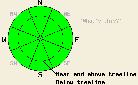
Avalanche danger remains LOW for all elevations and aspects. LOW danger means avalanches are unlikely not that they are impossible. Isolated areas of unstable snow may exist in complex terrain in and around areas of chutes, gullies, cliffs, and exposed rocks. Continue to use normal caution when travelling in the backcountry. |
|
|
|
The high pressure ridge over the region will allow the clear and dry weather to continue. Temperatures above 7000 ft. will remain warmer than the temperatures in the valleys due to a strong inversion. Currently above 7000 ft. most sensors report temperatures in the low 30's while those sensors in mountain valleys below 7000 ft. indicate temperatures in the the teens. The forecast calls for highs in the upper 30's and low 40's today in and tomorrow in the mountains above 7000 ft. Winds decreased and shifted back to the southwest yesterday and should remain light to moderate through tomorrow.
Yesterday in the Echo Summit area (more info) and in the Ophir Creek (more info, snowpit, video) drainage, soft unconsolidated snow still existed on most of the northerly aspects. Snowpits, handpits, ski cuts on test slopes, and other observations indicated a stable snowpack in sheltered areas. On some isolated leeward terrain features, wind loading had created small shallow wind slabs. Ski cuts on these features in both areas did cause some minor cracking. In the Ophir Creek area, this cracking was limited to within a foot of a person's skis and only went about 3 inches deep in the snowpack. In the Echo Summit area, deeper cracking occurred with depths of 8-10 inches. In both of these places, the wind slabs remained small and limited to areas near ridgelines.
In the Ophir Creek drainage, the Dec. facet layers existed within 4 ft. of the surface in some areas. Snowpit tests performed on these deeper persistent weak layers showed that they remain weak and that if they do start to collapse, the resulting fracture could travel along the weak layer (more info, snowpit, video). The tests also indicated that transmitting enough force through the snowpack to actually break these layers has become more difficult due to the strong snow above these old weaknesses.
Snowpack Concerns: Wind Slabs and Persistent Deep Slabs
5 days have passed since the last known avalanche activity. Data collected around the forecast area indicates that the snowpack continues to gain strength and that the strong snow on top of the persistent weak layers continues to insulate those layers from forces applied to the snow surface. On a regional scale, these conditions have made avalanche activity caused by a single skier, snowboarder, or snowmobiler unlikely. Some areas of unstable snow could still lurk in complex or extreme terrain in and around steep chutes, gullies, couloirs, cliffs and rock bands especially in wind loaded areas. Additionally, triggers larger than a single person recreating on a slope such as multiple people close together on the same slope, very large cornice collapses, or other avalanches could still provide the force needed to cause a failure in the older persistent weak layers. In this case large, deep, and destructive avalanches that could fracture across wide areas and far away from the trigger that caused the collapse would result. Like other avalanche activity actually triggering these persistent deep slabs has become unlikely, but if one of them does release catastrophic consequences would result.
Continue to exercise good travel techniques like moving one at time from safe zone to safe zone while in avalanche terrain. Soft snow and a sense of stability can easily impair judgement and create unsafe situations.
Avalanche danger remains LOW for all elevations and aspects. LOW danger means avalanches are unlikely not that they are impossible. Isolated areas of unstable snow may exist in complex terrain in and around areas of chutes, gullies, cliffs, and exposed rocks. Continue to use normal caution when travelling in the backcountry.
| 0600 temperature: | 26-32 deg. F. |
| Max. temperature in the last 24 hours: | 32-38 deg. F. |
| Average wind direction during the last 24 hours: | East shifting to the Southwest |
| Average wind speed during the last 24 hours: | 15-20 mph |
| Maximum wind gust in the last 24 hours: | 38 mph |
| New snowfall in the last 24 hours: | O inches |
| Total snow depth: | 63-90 inches |
For 7000-8000 ft: |
|||
| Thursday: | Thursday Night: | Friday: | |
| Weather: | Sunny | Clear | Sunny |
| Temperatures: | 37-43 deg. F. | 13-23 deg. F. | 34-41 deg. F. |
| Wind direction: | Variable | Variable | Variable |
| Wind speed: | Light | Light | Light |
| Expected snowfall: | O in. | O in. | O in. |
For 8000-9000 ft: |
|||
| Thursday: | Thursday Night: | Friday: | |
| Weather: | Sunny | Clear | Sunny |
| Temperatures: | 33-40 deg. F. | 23-31 deg. F. | 33-40 deg. F. |
| Wind direction: | Southwest | Southeast | West |
| Wind speed: | 10-15 mph | 10-15 mph | around 10 mph |
| Expected snowfall: | O in. | O in. | O in. |


This website is owned and maintained by the non-profit arm of the Sierra Avalanche Center. Some of the content is updated by the USDA avalanche forecasters including the forecasts and some observational data. The USDA is not responsible for any advertising, fund-raising events/information, or sponsorship information, or other content not related to the forecasts and the data pertaining to the forecasts.

