In partnership with: 
|
January 7, 2013 at 7:58 am |
|
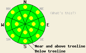
Near and above treeline, avalanche danger is LOW with pockets of MODERATE danger on all aspects on slopes 35 degrees and steeper due to recently formed wind slabs. Below treeline, avalanche danger is LOW with pockets of MODERATE danger on all aspects on slopes 32 degrees and steeper along the Sierra Crest from roughly Emerald Bay southward. Expect a wide variance in stability from one location to another within the forecast area due to large differences in locally accumulated new snow amounts on Sunday. |
|
|
|
High pressure will build over the forecast area today and tomorrow. Yesterday's weather system deposited less snowfall than expected in some areas and much more snow than expected in other areas. Only a trace of new snow accumulated along the Carson Range and along the northern third of the Sierra Crest portions of the forecast area. Further south along the Sierra Crest, 2 to 4 inches accumulated over the middle third and 4 to 12 inches accumulated over the southern third of the forecast area. Ridgetop winds out of the northeast remained light through mid day yesterday, before increasing to moderate in speed later yesterday afternoon and continuing overnight. Moderate to strong north to northeast winds are forecast to continue today through tomorrow. An air temperature inversion will allow for warming at the mid and upper elevations today and tomorrow with maximum daytime air temperatures above 7,000' expected to reach into the mid 20s to mid 30s today and into the mid 30s to low 40s tomorrow.
Observations made yesterday on Tamarack Peak (Mount Rose area), on Jake's Peak (West Shore Tahoe area), and on Poison Ridge (Bear Valley area) revealed highly variable conditions around the forecast area. On Jake's peak, 2 to 4 inches of new snow was poorly bonded to the old snow surface which ranged from unconsolidated snow to crust based on aspect and sun exposure. Long running human triggered loose snow avalanches were widespread on slopes steeper than 35 degrees. On Poison Ridge, 8 to 12 inches of new snow fell during the morning hours under light wind conditions. Lower density new snow was noted near the base of the storm snow and showed as a weak layer in snowpit tests. Minimal slab properties were noted within the new snow prior to increasing winds during the afternoon hours. More stable conditions were noted in areas such as Tamarack Peak that received little to no new snow. Click here for more info, photos, and videos from the above listed locations.
Avalanche Problem #1: Wind Slabs
Increasing northeast winds since yesterday afternoon will have built fresh wind slabs on a variety of aspects near and above treeline. Wind transport of old and new snow is expected to have created pockets of unstable wind slabs in lee areas over the past 18 hours. Thickness and presence of wind slabs is expected to vary greatly around the forecast area today due to significant differences in the amount of snow available for wind transport. Areas of wind loading and/or cross loading exist on a variety of aspects and could vary significantly from one side of a slope to another.
Avalanche Problem #2: Storm Slabs and Dry Loose Snow avalanches (Mainly of concern near the Sierra crest from roughly Emerald Bay southward)
In areas that received 3 or more inches of new snow yesterday, human triggered avalanches are possible. New snow was deposited on a wide variety of old snow surfaces ranging from crust to unconsolidated snow to surface hoar. Human triggered dry loose snow avalanches are possible in a variety of below treeline areas. As the new snow settles and gains increasing slab properties, human triggered slab avalanches will become increasingly possible in areas where new snow sits on top of either surface hoar or a lower density layer at the base of the new snow. Expect significant variances in below treeline snowpack stability from one location to another around the forecast area today.
Near and above treeline, avalanche danger is LOW with pockets of MODERATE danger on all aspects on slopes 35 degrees and steeper due to recently formed wind slabs. Below treeline, avalanche danger is LOW with pockets of MODERATE danger on all aspects on slopes 32 degrees and steeper along the Sierra Crest from roughly Emerald Bay southward. Expect a wide variance in stability from one location to another within the forecast area due to large differences in locally accumulated new snow amounts on Sunday.
| 0600 temperature: | 18 to 29 deg. F. |
| Max. temperature in the last 24 hours: | 20 to 29 deg. F. |
| Average wind direction during the last 24 hours: | Northeast |
| Average wind speed during the last 24 hours: | 17 mph |
| Maximum wind gust in the last 24 hours: | 41 mph |
| New snowfall in the last 24 hours: | N of Hwy 50, trace to 4 inches | S of Hwy 50, 4 to 12 inches |
| Total snow depth: | 62 to 86 inches |
For 7000-8000 ft: |
|||
| Monday: | Monday Night: | Tuesday: | |
| Weather: | Sunny skies with thin high cloud cover. | Partly cloudy skies. | Partly cloudy skies. |
| Temperatures: | 24 to 34 deg. F. | 24 to 30 deg. F. | 35 to 42 deg. F. |
| Wind direction: | NE | N to NE | NE |
| Wind speed: | 15 to 25 mph with gusts to 35 mph. | 15 to 20 mph with gusts to 35 mph, increasing to 25 to 30 mph with gusts to 40 mph after midnight. | 20 to 30 mph with gust to 40 mph. |
| Expected snowfall: | O in. | O in. | O in. |
For 8000-9000 ft: |
|||
| Monday: | Monday Night: | Tuesday: | |
| Weather: | Sunny skies with thin high cloud cover. | Partly cloudy skies. | Partly cloudy skies. |
| Temperatures: | 24 to 31 deg. F. | 23 to 29 deg. F. | 32 to 39 deg. F. |
| Wind direction: | NE to N | N | N |
| Wind speed: | 35 to 40 mph with gusts to 50 mph, decreasing to 25 to 30 mph with gusts to 40 mph in the afternoon. | 25 to 30 mph with gust to 40 mph, increasing to 35 to 40 mph with gusts to 60 mph after midnight. | 30 to 40 mph with gusts to 60 mph. |
| Expected snowfall: | O in. | O in. | O in. |


This website is owned and maintained by the non-profit arm of the Sierra Avalanche Center. Some of the content is updated by the USDA avalanche forecasters including the forecasts and some observational data. The USDA is not responsible for any advertising, fund-raising events/information, or sponsorship information, or other content not related to the forecasts and the data pertaining to the forecasts.

