In partnership with: 
|
January 12, 2013 at 7:50 am |
|
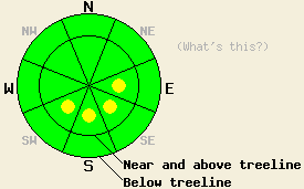
Near and above treeline, pockets of MODERATE avalanche danger exist on E-SE-S-SW aspects on slopes 35 degrees and steeper due to recently formed wind slabs. For all other areas avalanche danger is LOW. Please keep in mind that the definition of LOW danger includes small avalanches in isolated areas or extreme terrain. |
|
|
|
The weather system that created snow showers and a trace to 4 inches of new snow over the region yesterday has departed and skies have cleared overnight. Cold air is in place over the forecast area. Air temperatures this morning are below zero to the single digits across the elevation spectrum. Maximum daytime air temperatures above 7,000' are forecast to reach into the low to upper teens today. Ridgetop winds were out of the west through the day yesterday before shifting to northeast yesterday evening. Moderate speed northeast winds are forecast to continue for the next several days.
Observations made yesterday on Tamarack Peak (Mount Rose area), Silver Peak (Pole Creek area), and on Flagpole Peak (Echo Summit area) revealed that new snow from the past two days sits on top of a mix of unconsolidated snow and melt-freeze crusts. The old snow surface varies by aspect and location. Crust is common in areas that received significant sun Tuesday into Wednesday. Crust has also been noted below the recent new snow on N-NE-E aspects where significant warming occurred during this same time period. Other northerly aspects are free of crust at the old/new snow interface. Other recent field observations indicate that this is more location dependent than elevation dependent (photos, videos, more info).
Recent winds have formed fresh cornices and wind slabs in some areas and had minimal effects in other areas. Where more wind effect has occurred, tender, easily collapsible cornices exist. Skier triggered cracking of wind slabs just below ridgelines has also been noted in these areas. Where little wind effect has occurred, loose dry snow avalanche activity has been more prevalent due to the absence of slab formation (photos, videos, more info).
Avalanche Problem #1: Wind Slabs
Plenty of snow has been available for wind transport over the past few days. Wind slab formation has been most prevalent near and above treeline on E-SE-S-SW aspects. Wind slabs up to 1 foot thick have been observed in these areas. More isolated areas of wind slab may have formed last night on W-NW aspects as well. A few areas have noted significant wind affect below treeline. Isolated areas of instability may exist in these highly wind effected below treeline areas. In general, areas of instability will be found within greater areas of stable snow. Do not allow travel partners to become lax while employing travel practices designed to minimize risk.
Avalanche Problem #2: Loose Dry Snow Avalanches
In areas where little wind effect has occurred, slab avalanche activity is unlikely. Human triggered loose dry snow avalanches are more likely, especially in areas where crust exists at the old/new snow interface. Below average air temperatures since cold front passage Wednesday night have slowed new snow stabilization. Expect the continued possibility of loose dry snow avalanches in wind protected areas on a variety of aspects on slopes steeper than 35 degrees. These loose dry snow avalanches do not present a significant hazard alone, but when combined with secondary terrain exposures such as cliffs and creek beds, the likelihood of injury or burial increases significantly.
Near and above treeline, pockets of MODERATE avalanche danger exist on E-SE-S-SW aspects on slopes 35 degrees and steeper due to recently formed wind slabs. For all other areas avalanche danger is LOW. Please keep in mind that the definition of LOW danger includes small avalanches in isolated areas or extreme terrain.
| 0600 temperature: | -1 to 7 deg. F. |
| Max. temperature in the last 24 hours: | 12 to 16 deg. F. |
| Average wind direction during the last 24 hours: | West shifting to northeast |
| Average wind speed during the last 24 hours: | 18 mph |
| Maximum wind gust in the last 24 hours: | 33 mph |
| New snowfall in the last 24 hours: | Trace to 4 inches |
| Total snow depth: | 64 to 89 inches |
For 7000-8000 ft: |
|||
| Saturday: | Saturday Night: | Sunday: | |
| Weather: | Sunny skies, becoming mostly cloudy. | Mostly cloudy skies, becoming partly cloudy. | Partly cloudy skies. |
| Temperatures: | 13 to 20 deg. F. | -1 to 7 deg. F. | 14 to 21 deg. F. |
| Wind direction: | E | NE | NE |
| Wind speed: | 10 to 15 mph with gusts to 25 mph. | 10 to 15 mph with gusts to 30 mph. | 10 to 15 mph with gusts to 25 mph, increasing to 20 to 25 mph with gusts to 35 mph in the afternoon. |
| Expected snowfall: | O in. | O in. | O in. |
For 8000-9000 ft: |
|||
| Saturday: | Saturday Night: | Sunday: | |
| Weather: | Sunny skies, becoming mostly cloudy. | Mostly cloudy skies, becoming partly cloudy. | Partly cloudy skies. |
| Temperatures: | 10 to 15 deg. F. | 3 to 10 deg. F. | 12 to 16 deg. F. |
| Wind direction: | NE | NE | N |
| Wind speed: | 15 to 25 mph with gusts to 40 mph. | 15 to 25 mph with gusts to 40 mph. | 20 to 30 mph with gusts to 35 mph. Gusts increasing to 50 mph in the afternoon. |
| Expected snowfall: | O in. | O in. | O in. |


This website is owned and maintained by the non-profit arm of the Sierra Avalanche Center. Some of the content is updated by the USDA avalanche forecasters including the forecasts and some observational data. The USDA is not responsible for any advertising, fund-raising events/information, or sponsorship information, or other content not related to the forecasts and the data pertaining to the forecasts.

