In partnership with: 
|
January 14, 2013 at 7:46 am |
|
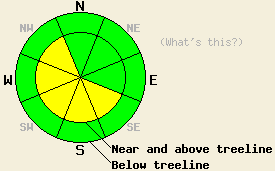
Near and above treeline, avalanche danger is MODERATE on SE-S-SW-W-NW aspects on slopes 35 degrees and steeper. New wind slabs formed late yesterday afternoon and last night. For all other areas, avalanche danger is LOW. |
|
|
|
Cold air that has been in place over the forecast area for the past two days is moving out of the area. Air temperature inversion will keep air temperatures at the lower elevations on the cool side while significant warming occurs at the mid and upper elevations today, tonight, and tomorrow. Ridgetop winds increased significantly late yesterday afternoon, becoming strong in speed. Winds are forecast to remain out of the E to NE and remain moderate to strong through tomorrow.
Observations made yesterday on Silver Peak (Pole Creek area) and on Castle Peak (Donner Summit area) revealed differences in upper snowpack stability as affected by winds in the late afternoon versus the morning and mid day hours. During the morning and mid day hours on Silver Peak, NE winds were light with little to no wind transport of snow on the ground. Good to very good snowpack stability was observed in the area (more info). After 2 pm, NE winds increased significantly and began to move snow. Blowing snow became visible along the Sierra Crest in above treeline areas. On Castle Peak, very small but unstable fresh wind slabs were observed in lee areas by 3:15 pm. These wind slabs became reactive to the weight of a skier with shooting cracks in slabs up to 1 foot deep. At that time these wind slabs did not extend more than a few feet down slope from ridgelines (photos, pit profile, more info).
Avalanche Problem #1: Wind Slabs
A fresh round of wind slab formation occurred late yesterday afternoon through last night. Small slabs observed late yesterday will have increased in size and depth during the overnight hours. Human triggered wind slab avalanches are possible today in recently wind loaded areas in near and above treeline terrain. SE-S-SW-W-NW aspects will hold the most well developed wind slabs and the greatest level of danger. Employ travel practices designed to minimize exposure and risk.
Near and above treeline, avalanche danger is MODERATE on SE-S-SW-W-NW aspects on slopes 35 degrees and steeper. New wind slabs formed late yesterday afternoon and last night. For all other areas, avalanche danger is LOW.
| 0600 temperature: | 1 to 7 deg. F. |
| Max. temperature in the last 24 hours: | 12 to 22 deg. F. |
| Average wind direction during the last 24 hours: | Northeast |
| Average wind speed during the last 24 hours: | 23 mph |
| Maximum wind gust in the last 24 hours: | 62 mph |
| New snowfall in the last 24 hours: | O inches |
| Total snow depth: | 64 to 89 inches |
For 7000-8000 ft: |
|||
| Monday: | Monday Night: | Tuesday: | |
| Weather: | Sunny skies. | Clear skies. | Sunny skies. |
| Temperatures: | 22 to 26 deg. F. | 22 to 32 deg. F. | 35 to 40 deg. F. |
| Wind direction: | E | E | E |
| Wind speed: | 25 to 35 mph with gusts to 45 mph. | 20 to 30 mph with gusts to 40 mph. | 20 to 30 mph with gusts to 40 mph. |
| Expected snowfall: | O in. | O in. | O in. |
For 8000-9000 ft: |
|||
| Monday: | Monday Night: | Tuesday: | |
| Weather: | Sunny skies. | Clear skies. | Sunny skies. |
| Temperatures: | 21 to 25 deg. F. | 22 to 32 deg. F. | 37 to 40 deg. F. |
| Wind direction: | E | E | E |
| Wind speed: | 35 to 45 mph with gusts to 65 mph. | 30 to 40 mph with gusts to 65 mph. Gusts decreasing to 55 mph after midnight. | 25 to 35 mph with gusts to 55 mph. Gusts decreasing to 45 mph in the afternoon. |
| Expected snowfall: | O in. | O in. | O in. |


This website is owned and maintained by the non-profit arm of the Sierra Avalanche Center. Some of the content is updated by the USDA avalanche forecasters including the forecasts and some observational data. The USDA is not responsible for any advertising, fund-raising events/information, or sponsorship information, or other content not related to the forecasts and the data pertaining to the forecasts.

