In partnership with: 
|
January 15, 2013 at 8:00 am |
|
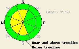
Near and above treeline, avalanche danger is MODERATE on S-SW-W-NW-N aspects on slopes steeper than 35 degrees due to wind slabs formed by the strong NE winds. For all other areas, avalanche danger is LOW. Even in the LOW danger areas unstable snow could still exist on isolated terrain features. |
|
|
|
Temperatures above 7000 ft. have continued to warm since yesterday. In the last 24 hours, the warmest temperatures were recorded this morning. Temperatures should warm up even more today as a high pressure ridge moves into the area. The forecast calls for clear skies and daytime highs in the mid 30's and low 40's above 7000 ft. both today and tomorrow. In the valleys temperatures remain much colder due to a strong temperature inversion. After a brief period of slightly weaker winds yesterday afternoon, the E and NE winds returned in force last night and remain strong this morning. As the high pressure ridges builds over the region, these winds should gradually decrease through tomorrow.
Observers reported widespread hard wind slabs in wind exposed near and above treeline terrain on Andesite Peak, Mt. Lincoln (more info, photos, video), and on Red Lake Peak yesterday (more info, photos, video). One small natural avalanche occurred on a near treeline W aspect near Caples Lake (more info, photo). The wind slabs existed on wind loaded W-SW aspects and cross loaded N-NW aspects and rested on top of a layer of soft weak snow above a crust. They ranged in depth from 6 inches in more protected areas to more than 3 ft in the most heavily wind loaded areas. Skier triggered shooting cracks and large collapses occurred on a W aspect on Andesite Ridge. Even larger cracks and collapsing occurred when several people weighted an adjacent low angle slope in that area. Human triggered shooting cracks up to 10 ft long also occurred on W-SW aspects on Mt. Lincoln (photo). Snowpit tests on Red Lake Peak (video), Mt. Lincoln (video), and on Andesite Ridge consistently indicated that the layer of weak snow below the wind slabs could easily fail and that fractures could travel along that weak layer. Wind loadeding continued in all of these areas until about noon yesterday when the rate of wind loading seemed to decrease.
Avalanche Problem #1: Wind Slabs
Human triggered avalanches involving the wind slabs that now exist on the wind loaded NW-W-SW aspects and the cross loaded N and S aspect will remain possible today. These slabs rest on top of a layer of weak snow and recent data (see above) indicates that this weak layer could break in response to a person on top of the snowpack. Due to the hard slab characteristics of these wind slabs they could fracture well above or to the side of the person who triggers the failure. These kind of hard slabs sometimes fail after several people have already put tracks on the slope. The largest and most fragile wind slabs will exist in near and above treeline terrain on S-SW-W-NW-N aspects.
Near and above treeline, avalanche danger is MODERATE on S-SW-W-NW-N aspects on slopes steeper than 35 degrees due to wind slabs formed by the strong NE winds. For all other areas, avalanche danger is LOW. Even in the LOW danger areas unstable snow could still exist on isolated terrain features.
| 0600 temperature: | 21-24 deg. F. |
| Max. temperature in the last 24 hours: | 21-24 deg. F. |
| Average wind direction during the last 24 hours: | Northeast |
| Average wind speed during the last 24 hours: | 30-50 mph |
| Maximum wind gust in the last 24 hours: | 51-86 mph |
| New snowfall in the last 24 hours: | O inches |
| Total snow depth: | 61-86 inches |
For 7000-8000 ft: |
|||
| Tuesday: | Tuesday Night: | Wednesday: | |
| Weather: | Partly cloudy then becoming sunny | Clear | Sunny |
| Temperatures: | 37-42 deg. F. | 30-37 deg. F. | 37-43 deg. F. |
| Wind direction: | Northeast | East | East |
| Wind speed: | 20-30 mph with gusts to 45 mph | 15-25 mph with gusts to 35 mph | 10-15 mph with gusts to 25 mph |
| Expected snowfall: | O in. | O in. | O in. |
For 8000-9000 ft: |
|||
| Tuesday: | Tuesday Night: | Wednesday: | |
| Weather: | Partly cloudy then becoming sunny | Clear | Sunny |
| Temperatures: | 36-42 deg. F. | 34-38 deg. F. | 37-44 deg. F. |
| Wind direction: | East | East | East |
| Wind speed: | 40-45 mph with gusts to 65 mph decreasing to 30-35 mph with gusts to 50 mph in the afternoon | 25-35 mph with gusts to 50 mph decreasing to 40 mph after midnight | 15-20 mph with gusts to 30 mph |
| Expected snowfall: | O in. | O in. | O in. |


This website is owned and maintained by the non-profit arm of the Sierra Avalanche Center. Some of the content is updated by the USDA avalanche forecasters including the forecasts and some observational data. The USDA is not responsible for any advertising, fund-raising events/information, or sponsorship information, or other content not related to the forecasts and the data pertaining to the forecasts.

