In partnership with: 
|
January 17, 2013 at 7:59 am |
|
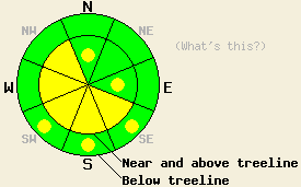
Near and above treeline on slopes steeper than 35 degrees, MODERATE avalanche danger exists on SE-S-SW-W-NW aspects with pockets of MODERATE danger on the E and N aspects due to recently formed wind slabs resting on a variety of weak layers and daytime warming. Below treeline avalanche danger is LOW with pockets of MODERATE danger on the SE-S-SW aspects due to daytime warming. |
|
|
|
The high pressure ridge should allow the sunny warm weather to continue in the mountains through the weekend. Inversion conditions should also persist keeping many of the low lying valleys cooler than the surrounding mountains. High temperatures above 7000 ft. should climb another 5 degrees above yesterday's highs allowing some areas above 7000 ft. to reach into the upper 40's and maybe even low 50's today. The east winds continue to gradually decrease. The forecast calls for them to finally drop below 30 mph by tonight and become light tomorrow.
Observations over the last several days have shown widespread hard wind slabs on the SW-W-NW aspects with some sporadic wind slabs on almost all other aspects in near and above treeline areas. These wind slabs rest on top of a variety of weaker snow ranging from a layer of soft snow to weak snow above and below a thin melt freeze crust. They range in depth from 6 inches in more protected areas to more than 3 ft in the most heavily wind loaded areas. Yesterday on Ralston Peak (video, snowpit, more info) snowpit tests, handpits, and other observations consistently indicated that the weak layers below the wind slabs could still fail and that fractures could travel along those weak layers. Observations and data also indicated that the slabs have started to become more difficult to trigger in this area. The east winds that created many of these slabs have also left a variety of wind affected snow on the surface ranging from scoured ice crusts to sastrugi to firm wind packed surfaces. Yesterday on more sun-exposed SE-S-SW aspects on Mt. Ralston ski cuts triggered small wet loose instabilities by noon.
Avalanche Problem #1: Wind Slabs
Even though data and observations indicate that the recently formed wind slabs are becoming more difficult to trigger in some areas, human triggered avalanches involving these wind slabs will remain possible in many places today. The varied weak layers under the slabs, variable slab thickness, and variable slab locations all add uncertainty into where the most fragile slabs exist. The NW-W-SW aspects hold the largest, most fragile, and most consistent wind slabs; however more scattered wind slabs that exhibit signs of instability have also been noted on all but the NE aspects. Due to the hard slab characteristics of these wind slabs they could fracture well above or to the side of the person who triggers the failure. These kind of hard slabs sometimes fail after several people have already put tracks on the slope. Careful snowpack evaluation and observations can help determine if a slope has these wind slabs on it.
Avalanche Problem #2: Loose Wet Avalanches:
Continued sunshine and warmer air temperatures will allow more widespread wet snow instabilities to form today. Small wet point releases, roller balls, and pinwheels may occur on the most sun exposed aspects especially near trees and rocks. The majority of these should remain relatively small due to the low sun angles and short January days and not involve enough snow to bury a person. However, they could still push a person off balance or into areas with undesirable consequences.
Near and above treeline on slopes steeper than 35 degrees, MODERATE avalanche danger exists on SE-S-SW-W-NW aspects with pockets of MODERATE danger on the E and N aspects due to recently formed wind slabs resting on a variety of weak layers and daytime warming. Below treeline avalanche danger is LOW with pockets of MODERATE danger on the SE-S-SW aspects due to daytime warming.
| 0600 temperature: | 28-35 deg. F. |
| Max. temperature in the last 24 hours: | 35-43 deg. F. |
| Average wind direction during the last 24 hours: | East |
| Average wind speed during the last 24 hours: | 25-35 mph |
| Maximum wind gust in the last 24 hours: | 40-51 mph |
| New snowfall in the last 24 hours: | O inches |
| Total snow depth: | 60-84 inches |
For 7000-8000 ft: |
|||
| Thursday: | Thursday Night: | Friday: | |
| Weather: | Sunny | Clear | Sunny |
| Temperatures: | 44-50 deg. F. | 30-36 deg. F. | 44-50 deg. F. |
| Wind direction: | East | East | East |
| Wind speed: | 10-15 mph with gusts to 25 mph | around 10 mph | around 10 mph |
| Expected snowfall: | O in. | O in. | O in. |
For 8000-9000 ft: |
|||
| Thursday: | Thursday Night: | Friday: | |
| Weather: | Sunny | Clear | Sunny |
| Temperatures: | 40-47 deg. F. | 31-37 deg. F. | 40-47 deg. F. |
| Wind direction: | East | East | East |
| Wind speed: | 25-30 mph with gusts to 50 mph decreasing to 10-15 mph with gusts to 25 mph in the afternoon | 15-20 mph with gusts to 30 mph | 10-15 mph with gusts to 25 mph in the morning |
| Expected snowfall: | O in. | O in. | O in. |


This website is owned and maintained by the non-profit arm of the Sierra Avalanche Center. Some of the content is updated by the USDA avalanche forecasters including the forecasts and some observational data. The USDA is not responsible for any advertising, fund-raising events/information, or sponsorship information, or other content not related to the forecasts and the data pertaining to the forecasts.

