In partnership with: 
|
January 21, 2013 at 8:00 am |
|
The avalanche danger remains LOW for all elevations and aspects on a regional scale. Even though avalanche activity is unlikley, small pockets of unstable snow may still lurk on isolated terrain features. Continue to use normal caution when travelling in the backcountry. |
|
|
|
Sunny spring-like weather will continue today. The east winds that picked up yesterday should decrease allowing daytime highs to climb back into the upper 40's and low 50's above 7000 ft. Below 7000 ft. inversion conditions still exist and temperatures in the valleys remain colder than those up high this morning. The high pressure ridge entrenched over the region should allow similar weather to continue through mid week.
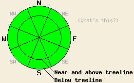
Yesterday observations in the Deep Creek drainage and along the ridge between Billy's Peak and the Sierra Crest showed varied surface conditions (photos, more info). On the sun exposed S aspects, some softening did occur allowing patches of 1-2 inch deep soft corn snow to form (photo). These areas quickly refroze as soon as the direct sunlight left the slope. The SE and SW aspects had less soft snow and mostly remained frozen (photo). Near and above treeline on the exposed N-NE-E aspects, firm wind scoured and wind packed surfaces existed (photo). Below treeline on the sheltered NW-N-NE aspects, several inches of soft unconsolidated snow remained on the surface (photo). In the valleys between 7600 ft. and 6800 ft. where temperatures have remained coldest, the surface snow has become so weak that ski cuts on some steep test slopes caused minor surface sluffing of the cold dry snow (photo). Other than that minor sluffing, snowpit tests, handpits, ski cuts on test slopes, and other observations revealed no signs of more serious instabilities in the snowpack.
Avalanche Problems #1: Wind Slabs
Some hard wind slabs that remain difficult to trigger still exist. These mainly reside on the SW-W-NW aspects but have also been noted to in very isolated areas on N, E, SE and S aspects in near and above treeline areas. Even though triggering these slabs will remain unlikely due to their strength, the characteristics of this avalanche problem warrant continued caution. Hard slabs tend to break well away from their triggers and often only break when the right trigger finds the right spot after several other people have already tracked out the slope.
Avalanche Problem #2: Loose Avalanches:
Some loose wet snow instabilities may form today due to daytime warming. If they do form, they should manifest as small roller balls, pinwheels and point releases. The most likely areas for these to form will be on very sun exposed southerly aspects near rocks or trees. Loose dry snow sluffs may also occur today on the lower elevation northerly aspects where a layer of weak cold snow exists on the snow surface. Neither of these loose snow problems should involve enough snow to bury a person, but they could change one's course of travel and push one into areas with other consequences.
The avalanche danger remains LOW for all elevations and aspects on a regional scale. Even though avalanche activity is unlikley, small pockets of unstable snow may still lurk on isolated terrain features. Continue to use normal caution when travelling in the backcountry.
| 0600 temperature: | 31-41 deg. F. |
| Max. temperature in the last 24 hours: | 38-44 deg. F. |
| Average wind direction during the last 24 hours: | East |
| Average wind speed during the last 24 hours: | 30 mph |
| Maximum wind gust in the last 24 hours: | 52 mph |
| New snowfall in the last 24 hours: | O inches |
| Total snow depth: | 58-83 inches |
For 7000-8000 ft: |
|||
| Monday: | Monday Night: | Tuesday: | |
| Weather: | Sunny | Clear | Sunny |
| Temperatures: | 45-53 deg. F. | 25-32 deg. F. | 43-51 deg. F. |
| Wind direction: | East | Variable | Variable |
| Wind speed: | Around 10 mph | Light | Light |
| Expected snowfall: | O in. | O in. | O in. |
For 8000-9000 ft: |
|||
| Monday: | Monday Night: | Tuesday: | |
| Weather: | Sunny | Clear | Sunny |
| Temperatures: | 40-50 deg. F. | 25-35 deg. F. | 38-48 deg. F. |
| Wind direction: | East | Variable | South |
| Wind speed: | 15-20 mph with gusts to 30 mph in the morning becoming light in the afternoon | Light | Light in the morning increasing to 15-20 mph with gusts to 30 mph in the afternoon |
| Expected snowfall: | O in. | O in. | O in. |


This website is owned and maintained by the non-profit arm of the Sierra Avalanche Center. Some of the content is updated by the USDA avalanche forecasters including the forecasts and some observational data. The USDA is not responsible for any advertising, fund-raising events/information, or sponsorship information, or other content not related to the forecasts and the data pertaining to the forecasts.

