In partnership with: 
|
February 3, 2013 at 7:40 am |
|
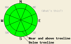
The avalanche danger remains LOW for all elevations and aspects. Continue to use normal caution when travelling in the backcountry. |
|
|
|
The cloud cover that appeared over the region yesterday started to dissipate last night. Today the forecast calls for continued clearing and mostly sunny skies. The high pressure ridge parked over the forecast area should allow spring-like weather to continue. The increased SW winds should start to diminish today. By tomorrow the winds should drop below 5 mph. Daytime high's for today and tomorrow should climb back into the low to mid 40's above 7000 ft.
Overcast skies and light winds kept the snow surface frozen in Negro Canyon (photos, more info) and on Ophir Peak (photos, snowpit, more info) yesterday. On the southerly aspects in both areas, thick frozen melt-freeze crusts existed at all elevations. About a quarter to a half an inch of softer snow formed on the due S aspects below 6800 ft in the Negro Canyon area by 1pm. On the northerly aspects, frozen rain crusts .5-2 inches thick existed above softer weaker snow at all elevations. Snowmobiles and people walking in boots could break through this crust above 7200 ft. in Negro Canyon and on Ophir Peak, but the crust would support a person on skis or a snowboard. Snowpit data, ski cuts, hand pits, probing, and other general observations did not reveal any signs of instability in these areas yesterday.
Avalanche Concerns:
Avalanche activity will remain unlikely today. Today's sunshine should allow the snow surface to soften on the sun exposed southerly aspects. Enough soft snow may form by this afternoon for small isolated wet loose snow instabilities such as roller balls, pin wheels, or small point releases to occur. Some hard wind slabs do still remain on high elevation SE-S-SW-W aspects. Triggering these wind slabs remains unlikely. In the unlikely event that a person triggers either of these kinds of avalanches, neither of them should involve enough snow to bury a person. However, small amounts of moving snow can push a person off course or off his/her feet resulting in other consequences.
The avalanche danger remains LOW for all elevations and aspects. Continue to use normal caution when travelling in the backcountry.
| 0600 temperature: | 31-36 deg. F. |
| Max. temperature in the last 24 hours: | 38-44 deg. F. |
| Average wind direction during the last 24 hours: | Southwest |
| Average wind speed during the last 24 hours: | 20-25 mph |
| Maximum wind gust in the last 24 hours: | 43 mph |
| New snowfall in the last 24 hours: | O inches |
| Total snow depth: | 55-81 inches |
For 7000-8000 ft: |
|||
| Sunday: | Sunday Night: | Monday: | |
| Weather: | Partly cloudy then becoming sunny | Clear | Partly cloudy |
| Temperatures: | 37-44 deg. F. | 21-29 deg. F. | 39-46 deg. F. |
| Wind direction: | Variable | Variable | Variable |
| Wind speed: | Light | Light | Light |
| Expected snowfall: | O in. | O in. | O in. |
For 8000-9000 ft: |
|||
| Sunday: | Sunday Night: | Monday: | |
| Weather: | Partly cloudy then becoming sunny | Clear | Partly cloudy |
| Temperatures: | 35-43 deg. F. | 25-31 deg. F. | 40-46 deg. F. |
| Wind direction: | Southwest shifting to the west in the afternoon | East | Variable |
| Wind speed: | 20-25 mph with gusts to 40 mph decreasing to 10-15 mph in the afternoon | 5-15 mph with gusts to 25 mph after midnight | Light |
| Expected snowfall: | O in. | O in. | O in. |


This website is owned and maintained by the non-profit arm of the Sierra Avalanche Center. Some of the content is updated by the USDA avalanche forecasters including the forecasts and some observational data. The USDA is not responsible for any advertising, fund-raising events/information, or sponsorship information, or other content not related to the forecasts and the data pertaining to the forecasts.

