In partnership with: 
|
February 7, 2013 at 7:52 am |
|
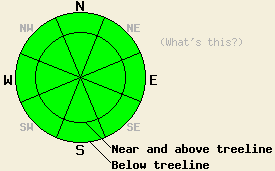
For most of today, avalanche danger will remain LOW for all elevations and aspects. Increasing avalanche danger will occur this evening and during the overnight hours as wind slabs form near and above treeline on NW-N-NE-E-SE aspects and human triggered avalanches become possible. |
|
|
|
A strong cold front will bring snowfall to the forecast area today. Cloud cover will continue to increase this morning along with moderate to strong southwest winds. Snowfall is expected to begin this afternoon with up to 2 inches today and an additional 1 to 4 inches tonight through Friday. Cold air associated with frontal passage will keep maximum daytime air temperatures above 7,000' in the mid 20s to 30s today. Air temperatures will fall to the single digits and teens tonight for most areas. Maximum air temperatures in the teens and 20s are forecast for tomorrow. Wind speeds are expected to peak today before decreasing to moderate in speed and shift to the west and northwest tonight and tomorrow
Observations made yesterday in Upper Ophir Creek (Mount Rose area) matched well with other recent observations from around the forecast area. Faceting processes are at work in the top 1 foot or so of the snowpack on many NW-N-NE-E aspects above 7,200'. Near crust facets are fairly weak, but snowpit tests indicate that propagation is unlikely upon weak layer collapse in most areas. Isolated areas along the eastern boundary of the forecast area have shown an overall shallow snowpack with weaker December facets that hold the ability to propagate. Collapse of this December weak layer has proven very difficult to trigger. These weak layers are not an instability issue for this storm event, but warrant monitoring during future snow loading events (pit profiles, photos, videos, more info).
Around the forecast area, snow surface conditions are mostly supportable crust. Areas with exposure to NE winds are scoured down to the most recent rain crust. Melt-freeze conditions are well established on SE-S-SW aspects. E and W aspects hold a mix of melt-freeze and dry snow conditions. In near and below treeline areas with protection from NE winds, N-NE aspects hold 0.5 to 2 inches of dry, lightly faceted recent storm snow on top of supportable rain crust. These areas of faceted surface snow on top of smooth rain crust may become an issue as a weak failure layer for storm slabs tomorrow if the upper end of forecast snowfall amounts are reached.
Avalanche Concerns will remain at a minimum until this evening or tonight. Southerly aspects that hold melt freeze surface crust are expected to remain frozen today with no wet surface snow formation. After the onset of precipitation this afternoon, new wind slabs will begin to build near and above treeline in wind loaded areas on NW-N-NE-E-SE aspects.
Avalanche Concern #1: Wind Slabs
With only a few inches of snowfall expected over the next 36 hours, these slabs will be slow to form and small in size. By this evening, isolated areas of small and shallow wind slabs may exist. Slab size and depth is expected to increase in size and depth during the overnight hours as snowfall continues. Depending on just how much snowfall occurs will dictate whether or not these slabs become a hazard to backcountry travelers or remain too small to pose much threat.
For most of today, avalanche danger will remain LOW for all elevations and aspects. Increasing avalanche danger will occur this evening and during the overnight hours as wind slabs form near and above treeline on NW-N-NE-E-SE aspects and human triggered avalanches become possible.
| 0600 temperature: | 17 to 28 deg. F. |
| Max. temperature in the last 24 hours: | 36 to 45 deg. F. |
| Average wind direction during the last 24 hours: | Southwest |
| Average wind speed during the last 24 hours: | 36 mph |
| Maximum wind gust in the last 24 hours: | 54 mph |
| New snowfall in the last 24 hours: | O inches |
| Total snow depth: | 54 to 80 inches |
For 7000-8000 ft: |
|||
| Thursday: | Thursday Night: | Friday: | |
| Weather: | Mostly cloudy to cloudy skies with snow in the afternoon. | Cloudy skies with snow showers. | Cloudy skies with snow showers. |
| Temperatures: | 29 to 35 deg. F. | 8 to 15 deg. F. | 14 to 21 deg. F. |
| Wind direction: | SW | SW shifting to W | NW |
| Wind speed: | 20 to 30 mph with gusts to 40 mph. | 20 to 25 mph with gusts to 40 mph, decreasing to 10 to 15 mph with gusts to 25 mph after midnight. | 15 to 20 mph with gusts to 30 mph. |
| Expected snowfall: | Up to 2 in. | 1 to 3 in. | Up to 1 in. |
For 8000-9000 ft: |
|||
| Thursday: | Thursday Night: | Friday: | |
| Weather: | Mostly cloudy to cloudy skies with snow in the afternoon. | Cloudy skies with snow showers. | Cloudy skies with snow showers. |
| Temperatures: | 24 to 30 deg. F. | 8 to 14 deg. F. | 13 to 19 deg. F. |
| Wind direction: | SW | SW shifting to W | NW |
| Wind speed: | 40 to 50 mph with gusts to 75 mph. | 30 to 35 mph with gusts to 50 mph, decreasing to 20 to 25 mph with gusts to 40 mph after midnight. | 20 to 30 mph. Gusts to 35 mph increasing to 45 mph in the afternoon. |
| Expected snowfall: | Up to 2 in. | 1 to 3 in. | Up to 1 in. |


This website is owned and maintained by the non-profit arm of the Sierra Avalanche Center. Some of the content is updated by the USDA avalanche forecasters including the forecasts and some observational data. The USDA is not responsible for any advertising, fund-raising events/information, or sponsorship information, or other content not related to the forecasts and the data pertaining to the forecasts.

