In partnership with: 
|
February 14, 2013 at 8:00 am |
|
The avalanche danger remains LOW for all elevations and aspects. Continue to use normal caution when traveling in the backcountry. |
|
|
|
The forecast calls for sunny skies, decreasing wind, and warmer temperatures over the next few days. Today's highs should climb into the upper 30's and low 40's above 7000 ft. Temperatures should get even warmer tomorrow. The ENE winds should begin to decrease today and continue decreasing through tomorrow. The high pressure ridge should remain in place over the west coast through the weekend.
On Red Lake Peak yesterday, consistent ENE winds and temperatures near freezing kept the snow surface firm and mostly frozen in the majority of areas. The plentiful sunshine did provide enough warmth for 2-3 inches of soft corn snow to form on some of the S-SE aspects in areas sheltered from the ENE winds (photos, more info). On all of the southerly aspects a thick layer of firm melt freeze snow exists below the surface. On the open and exposed N-NE-E aspects in this area, the recent winds have exposed old crusts and created firm wind packed surfaces (photos, more info). Below these firm surfaces a layer of facets does exist. Observations yesterday did not reveal areas where slab layers exist above this weak layer. On some of the NW-W aspects, the strong ENE winds have formed some small wind slabs. Numerous tests on these small slabs indicated that they have bonded well to the snowpack below them (photos, more info).
Avalanche Concerns:
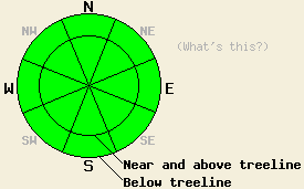
Avalanche activity will remain unlikely. Warmer temperatures, plentiful sunshine, and a decrease in the cold ENE wind should allow more soft wet corn snow to form on the sun exposed aspects that face the southern half of the compass today. Since very little recent storm snow remains on the majority of these E-SE-S-SW-W aspects, wet snow instabilities should remain limited to small roller balls and small isolated point releases. The winds slabs formed over the last several days by the ENE winds seem to have bonded well to the snow below them. Human triggering of shallow wind slabs that exist in near and above treeline terrain on SE-S-SW-W-NW aspects will also remain unlikely today.
The avalanche danger remains LOW for all elevations and aspects. Continue to use normal caution when traveling in the backcountry.
| 0600 temperature: | 23-28 deg. F. |
| Max. temperature in the last 24 hours: | 32-40 deg. F. |
| Average wind direction during the last 24 hours: | East northeast |
| Average wind speed during the last 24 hours: | 20-35 mph |
| Maximum wind gust in the last 24 hours: | 56 mph |
| New snowfall in the last 24 hours: | O inches |
| Total snow depth: | 56-79 inches |
For 7000-8000 ft: |
|||
| Thursday: | Thursday Night: | Friday: | |
| Weather: | Sunny | Clear | Sunny |
| Temperatures: | 38-45 deg. F. | 20-28 deg. F. | 42-49 deg. F. |
| Wind direction: | East | East | Variable |
| Wind speed: | 10-15 mph with gusts to 25 mph | 10-15 mph with gusts to 25 mph | Light |
| Expected snowfall: | O in. | O in. | O in. |
For 8000-9000 ft: |
|||
| Thursday: | Thursday Night: | Friday: | |
| Weather: | Sunny | Clear | Sunny |
| Temperatures: | 33-40 deg. F. | 20-27 deg. F. | 39-46 deg. F. |
| Wind direction: | East | East | East |
| Wind speed: | 15-20 mph with gusts to 30 mph | 10-15 mph with gusts to 25 mph | 10-15 mph with gusts to 25 mph |
| Expected snowfall: | O in. | O in. | O in. |


This website is owned and maintained by the non-profit arm of the Sierra Avalanche Center. Some of the content is updated by the USDA avalanche forecasters including the forecasts and some observational data. The USDA is not responsible for any advertising, fund-raising events/information, or sponsorship information, or other content not related to the forecasts and the data pertaining to the forecasts.

