In partnership with: 
|
February 19, 2013 at 7:49 am |
|
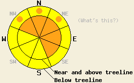
Avalanche danger starting at LOW danger early this morning will steadily increase as the day progresses. Avalanche danger is expected to become CONSIDERABLE this afternoon near and above treeline on NW-N-NE-E-SE aspects on slopes 35 degrees and steeper. Below treeline, avalanche danger will increase to MODERATE danger with pockets of CONSIDERABLE danger on NW-N-NE aspects on slopes 35 degrees and steeper. |
|
|
|
Light snowfall overnight deposited 2 to 3 inches of new snow along the Sierra Crest and a trace to 1 inch of new snow along the Carson Range. Snowfall intensity is expected to increase this afternoon and evening when the bulk of the 4 to 10 inches of forecast snowfall for today will occur. An additional 1 to 4 inches of snowfall tonight is expected to bring new snowfall amounts up to 8 to 14 inches over the next 24 hours. Cold front passage last night has dropped air temperatures in most areas 7 to 10 degrees colder than 24 hours ago. Ridgetop winds became strong last night. Ridgetop gusts to 85 mph are expected today. Winds are forecast to slowly decrease in speed starting this afternoon, shifting to the NW to N tonight and remaining moderate in speed tomorrow.
Observations made yesterday on Angora Peak (Desolation Wilderness area) as well as data received from Huckleberry Canyon (Echo Summit area) matched well with other recent observations from around the forecast area (pit profiles, videos, photos, more info). Faceted snow layers are widespread on northerly aspects within the top 1 foot of the snowpack. For the most part these layers are in decent condition to handle new snow loading. The layer anticipated to have the most potential to contribute to instability is the snow surface layer of near surface faceted snow crystals and isolated areas of patchy surface hoar that exists above 7,300' to 7,800' on some NW-N-NE aspects in below treeline and near treeline terrain. These thin weak layers sit on top of smooth rain crust. This weak layer and bed surface combo could contribute to instability at or just below the old/new snow interface as the upcoming storm cycle progresses.
With a few isolated exceptions of shallow snowpack areas in the Carson Range, near crust facet layers that exist in the upper and middle portions of the snowpack are stable. Propagation tests targeting these faceted weak layers have pointed to propagation as unlikely in the event of weak layer collapse under upcoming snow loading conditions (info on observed exceptions here and here).
On southerly aspects at all elevations and in above treeline areas on all other aspects, new snow will fall on a mix of melt-freeze crust and rain crust. In these areas there are no weak layers of concern below the old snow surface at this time.
Avalanche Problem #1: Wind Slabs
The combination of new snow and wind today will create areas of wind loading in near and above treeline terrain. Fresh wind slabs will build in size, distribution, and depth as the day progresses. A period of rapid wind slab development is expected this afternoon as snowfall intensity increases. Wind slabs will form in lee areas mainly on NW-N-NE-E-SE aspects.
Avalanche Problem #2: Storm Slabs
In below treeline and near treeline areas on NW-N-NE aspects that hold an old snow surface layer of near surface facets (old powder) not capped by melt-freeze crust, unstable storm slabs may form today. These slabs may fail at or just below the old/new snow interface. The near surface facets will provide the weak layer and the rain crust below will provide a smooth and efficient bed surface. This will be an increasing issue as the day progresses and snowfall intensity increases this afternoon.
Avalanche Problem, #3: Loose Dry Avalanches
In wind protected areas where new snow is deposited on top of melt-freeze or rain crust at the old snow surface, loose dry avalanches will be possible today. Loose dry avalanches could be long running in steep areas where smooth crust covers a large elevation span.
Avalanche danger starting at LOW danger early this morning will steadily increase as the day progresses. Avalanche danger is expected to become CONSIDERABLE this afternoon near and above treeline on NW-N-NE-E-SE aspects on slopes 35 degrees and steeper. Below treeline, avalanche danger will increase to MODERATE danger with pockets of CONSIDERABLE danger on NW-N-NE aspects on slopes 35 degrees and steeper.
| 0600 temperature: | 13 to 23 deg. F. |
| Max. temperature in the last 24 hours: | 30 to 39 deg. F. |
| Average wind direction during the last 24 hours: | Southwest |
| Average wind speed during the last 24 hours: | 32 mph |
| Maximum wind gust in the last 24 hours: | 78 mph |
| New snowfall in the last 24 hours: | 2 to 3 inches |
| Total snow depth: | 55 to 81 inches |
For 7000-8000 ft: |
|||
| Tuesday: | Tuesday Night: | Wednesday: | |
| Weather: | Cloudy skies with snow. | Cloudy skies with snow in the evening. Scattered snow showers after midnight. | Mostly cloudy skies with a slight chance of snow showers. |
| Temperatures: | 21 to 27 deg. F. | 8 to 15 deg. F. | 22 to 28 deg. F. |
| Wind direction: | SW | NW | N |
| Wind speed: | 35 to 40 mph with gusts to 55 mph, decreasing to 25 to 35 mph with gusts to 45 mph in the afternoon. | 15 to 20 mph with gusts to 30 mph. | 20 to 25 mph with gusts to 35 mph, decreasing to 10 to 15 mph with gusts to 25 mph in the afternoon. |
| Expected snowfall: | 4 to 8 in. | 1 to 3 in. | 0 to trace in. |
For 8000-9000 ft: |
|||
| Tuesday: | Tuesday Night: | Wednesday: | |
| Weather: | Cloudy skies with snow. | Cloudy skies with snow in the evening. Scattered snow showers after midnight. | Mostly cloudy skies with a slight chance of snow showers. |
| Temperatures: | 14 to 22 deg. F. | -1 to 9 deg. F. | 16 to 22 deg. F. |
| Wind direction: | SW | SW shifting to N after midnight. | N |
| Wind speed: | 55 to 60 mph with gusts to 85 mph, decreasing to 40 to 45 mph with gusts to 70 mph in the afternoon. | 35 to 40 mph with gusts to 60 mph, shifting and decreasing to 25 to 30 mph with gusts to 40 mph after midnight. | 25 to 35 mph. Gusts to 50 mph decreasing to 40 mph in the afternoon. |
| Expected snowfall: | 6 to 10 in. | 2 to 4 in. | 0 to trace in. |


This website is owned and maintained by the non-profit arm of the Sierra Avalanche Center. Some of the content is updated by the USDA avalanche forecasters including the forecasts and some observational data. The USDA is not responsible for any advertising, fund-raising events/information, or sponsorship information, or other content not related to the forecasts and the data pertaining to the forecasts.

