In partnership with: 
|
February 21, 2013 at 7:52 am |
|
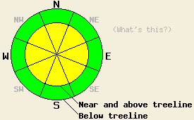
In near and above treeline terrain, MODERATE avalanche danger exists on all aspects on slopes 35 degrees and steeper where wind slabs rest on weak snow. Human triggered avalanches will remain possible today in these areas. Below treeline the avalanche danger has decreased to LOW even though some small loose snow instabilities do remain possible. |
|
|
|
A small and fast moving low pressure moving through the area this morning did produce some snow showers. Many remote sensors have recorded about half an inch of snow as of 6am this morning. The clouds and precipitation should diminish quickly as this system moves away from the region. A small high pressure should fill in behind this system allowing continued northerly flow. This developing high pressure should also bring partly to mostly sunny skies to the area this afternoon and tomorrow. Temperatures today should climb a few degrees above yesterday's highs, and tomorrow temps should continue to climb even higher.
On Meiss Ridge (photos, video, more info), Andesite Ridge (photos, video, more info), and Silver Peak (photos, snowpit, more info) yesterday, fragile wind slabs existed on many wind loaded aspects. Skier triggered shooting cracks, test slope failures, and unstable test results occurred on W-SW-S aspects in all three areas. On Andesite Ridge these wind slabs measured around 6 inches in depth. On Silver Peak they reached up to 1 ft in depth, and on Meiss Ridge they measured as deep as 3 ft. None of these slabs extended very far downslope. The NE winds that occurred Tuesday night had scoured many of the above treeline exposed N-NE aspects back to the old surface crusts on Andesite Ridge and along Meiss Ridge removing some of the wind slabs that had formed earlier on those aspects. On Silver Peak where more sheltered N-NE slopes exist, wind slabs 1-2 ft deep remained on these aspects in near and above treeline terrain. Below these new wind slabs a variety of weak layers ranging from low density storm snow to weak sugary snow around the old crusts exists. All of the failures (cracks, test slopes, and snowpit tests) mentioned above occurred above the older weak layers within the new snow. Below treeline on Silver Peak skier triggered loose dry sluffs involving the 4-6 inches of new snow also occurred on steep N-NE test slopes.
Avalanche Problem #1: Wind Slabs
Wind slabs exist on a variety of aspects due to the shifting winds during the recent storm. Below these slabs a layer of softer low density snow exists with a mix of crusts and old weak sugary snow below that. Tests and observations have shown these slabs remain sensitive to human triggering. Fragile slabs reside on the SW wind loaded NW-N-NE-E-SE aspects in some areas and also exist on the W-SW-S aspects due to wind loading from the NE winds. In areas where limited snow accumulated or significant scouring has occurred, these slabs should remain small and shallow. Some larger wind slabs 1-3 ft thick could exist in the most heavily wind-loaded areas along the Sierra Crest.
Avalanche Problem, #2: Loose Dry Avalanches
In areas where new snow exists on steep slopes, loose dry avalanches will also remain possible today. Loose dry avalanches could be long running in steep areas where they slide on smooth crusts.
In near and above treeline terrain, MODERATE avalanche danger exists on all aspects on slopes 35 degrees and steeper where wind slabs rest on weak snow. Human triggered avalanches will remain possible today in these areas. Below treeline the avalanche danger has decreased to LOW even though some small loose snow instabilities do remain possible.
| 0600 temperature: | 12-16 deg. F. |
| Max. temperature in the last 24 hours: | 19-29 deg. F. |
| Average wind direction during the last 24 hours: | Northeast shifting to the west |
| Average wind speed during the last 24 hours: | 5-20 mph |
| Maximum wind gust in the last 24 hours: | 47 mph |
| New snowfall in the last 24 hours: | .5 inches |
| Total snow depth: | 58-83 inches |
For 7000-8000 ft: |
|||
| Thursday: | Thursday Night: | Friday: | |
| Weather: | A chance of scattered snow showers before 10am then becoming mostly sunny. | Partly cloudy | Partly sunny |
| Temperatures: | 24-31 deg. F. | 15-25 deg. F. | 34-40 deg. F. |
| Wind direction: | North | North | North |
| Wind speed: | 10-15 mph | 10-15 mph with gusts to 25 mph | 10-15 mph becoming light in the afternoon |
| Expected snowfall: | less than 1 in. | O in. | O in. |
For 8000-9000 ft: |
|||
| Thursday: | Thursday Night: | Friday: | |
| Weather: | A chance of scattered snow showers before 10am then becoming mostly sunny. | Partly cloudy | Partly sunny |
| Temperatures: | 22-26 deg. F. | 11-19 deg. F. | 30-36 deg. F. |
| Wind direction: | North | North | North |
| Wind speed: | 15-20 mph with gusts to 30 mph | 15-25 mph with gusts to 35 mph | 15-25 mph with gusts to 35 mph |
| Expected snowfall: | less than 1 in. | O in. | O in. |


This website is owned and maintained by the non-profit arm of the Sierra Avalanche Center. Some of the content is updated by the USDA avalanche forecasters including the forecasts and some observational data. The USDA is not responsible for any advertising, fund-raising events/information, or sponsorship information, or other content not related to the forecasts and the data pertaining to the forecasts.

