In partnership with: 
|
March 10, 2013 at 7:07 am |
|
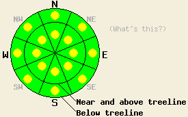
Both above and below treeline, areas of MODERATE avalanche danger exist on all aspects on slopes 35 degrees and steeper due to a combination of persistent slabs, new wind slabs, and wet snow instabilities in some areas. Expect to find localized areas of instability within large surrounding areas of stable snow. |
|
|
|
The northeast winds increased yesterday and remained strong through last night. These winds should begin to decrease today and temperatures should start to increase as a high pressure becomes established over the forecast area. By tomorrow the winds should shift to the west and become light. The forecast for today and tomorrow calls for sunny skies and daytime highs in the mid to upper 40's above 7000 ft.
Yesterday skier and snowboarder triggered avalanches occurred above Mt. Rose Highway (photos, snowpit, more info) and in the Carson Pass (photos, more info) area on steep north facing aspects. In the Mt. Rose incident the snowboarder who triggered the slide ended up buried near the road. This slide occurred on an avalanche path below the Gas-Ex exploders and failed on a layer of faceted snow below the recent storm snow. Across the Mt. Rose Highway in similar terrain several snowpit tests and general observations showed a mostly stable snowpack without a well developed weak layer below the recent snow (photos, more info). In the Carson Pass area the avalanche failed within the new snow as 3-6 inch slab broke away from the snow below it. This slide did not entrain any people.
Observations from the Mt. Rose backcountry and along the Sierra Crest indicated that the NE winds increased during the day and started to transport significant amounts of snow away from the N-NE-E aspects and onto the SE-S-SW-W-NW aspects (photo).
Avalanche Problem #1: Wind Slabs
The NE winds have created new wind slabs on the near and above treeline SE-S-SW-W-NW aspects during the last 24 hours. Human triggered avalanches involving these wind slabs will be possible on these aspects today. These slabs should remain limited to areas near ridgelines where the most wind loading has occurred. Sun and warm temperatures could help make it easier to trigger these wind slabs today.
Avalanche Problem #2: Persistent Slabs
As the recent snow has continued to consolidate it has become more slab like. In some areas these soft slabs rest on top of persistent weak layers of sugary snow (facets). In other areas either this persistent weak layer does not exist, or the NE winds have scoured much of the soft slab away. This combination of recent snow with increasing slab characteristics above a weak layer represents two of the ingredients necessary for an avalanche. All that is missing is the right trigger on the right slope. Human triggered avalanches will remain will remain possible on NW-N-NE aspects where a soft slab of recent snow exists on top of a persistent weak layer.
Taking the time to dig into the snowpack and look for the presence or absence of this weak layer maybe the only way to determine snowpack stability at a specific location today. This will become more important if other more obvious signs of instability such as collapsing and whumphing do not exist. Keep in mind that instability may actually be increasing in some areas over what was observed since Wednesday as the recent storm snow becomes a more cohesive slab, especially in areas that were wind protected during the storm cycle.
Avalanche Problem #3: Wet Avalanches
The combination of warm temperatures at all elevations, decreasing NE winds, and March sunshine will allow wet snow instabilities to form today. Natural and human triggered loose wet roller balls, pinwheels, and point releases should comprise most of the wet snow instabilities. It is not impossible that a wet slab avalanche could occur today on the most sun-exposed slopes where significant recent snow exists. This warming could also make the wind slabs formed by last night's NE winds more fragile in some areas. The sun-exposed SE-S-SW aspects represent the most likely places for wet snow instabilities to form. Some wet snow instabilities could also form on E and W aspects.
Both above and below treeline, areas of MODERATE avalanche danger exist on all aspects on slopes 35 degrees and steeper due to a combination of persistent slabs, new wind slabs, and wet snow instabilities in some areas. Expect to find localized areas of instability within large surrounding areas of stable snow.
| 0600 temperature: | 21-27 deg. F. |
| Max. temperature in the last 24 hours: | 27-36 deg. F. |
| Average wind direction during the last 24 hours: | Northeast |
| Average wind speed during the last 24 hours: | 20-35 mph |
| Maximum wind gust in the last 24 hours: | 46-62 mph |
| New snowfall in the last 24 hours: | O inches |
| Total snow depth: | 64-92 inches |
For 7000-8000 ft: |
|||
| Sunday: | Sunday Night: | Monday: | |
| Weather: | Sunny | Clear | Mostly sunny |
| Temperatures: | 40-47 deg. F. | 22-28 deg. F. | 41-48 deg. F. |
| Wind direction: | Northeast | Variable | Variable |
| Wind speed: | 15-20 mph with gusts to 30 mph in the morning | Light | Light |
| Expected snowfall: | O in. | O in. | O in. |
For 8000-9000 ft: |
|||
| Sunday: | Sunday Night: | Monday: | |
| Weather: | Sunny | Clear | Mostly sunny |
| Temperatures: | 41-47 deg. F. | 20-27 deg. F. | 41-47 deg. F. |
| Wind direction: | Northeast | Northeast | West |
| Wind speed: | 20-25 mph with gusts to 40 mph decreasing to 10-15 mph with gusts to 25mph this afternoon | 10-15 mph in the evening becoming light overnight | 10-15 mph in the morning becoming light during the day |
| Expected snowfall: | O in. | O in. | O in. |


This website is owned and maintained by the non-profit arm of the Sierra Avalanche Center. Some of the content is updated by the USDA avalanche forecasters including the forecasts and some observational data. The USDA is not responsible for any advertising, fund-raising events/information, or sponsorship information, or other content not related to the forecasts and the data pertaining to the forecasts.

