In partnership with: 
|
March 21, 2013 at 7:01 am |
|
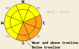
Both above and below treeline, CONSIDERABLE avalanche danger is expected to today on E-SE-S aspects on slopes 35 degrees and steeper due to the possibility of natural and human triggered loose wet and wet slab avalanches. For all other areas, avalanche danger is MODERATE due to a mix of wet snow instability and lingering wind slab instability on slopes 35 degrees and steeper. |
|
|
|
The storm system that impacted the region yesterday has moved off to the east. Sunny skies, above freezing air temperatures, and decreasing winds shifting from SW to NW are forecast for today. With the exception of the Donner Summit area, storm snow totals and new snow amounts from the past 24 hours are fairly consistent across the forecast area. The vast majority of areas received 2 to 4 inches of new snow over the past 24 hours, bringing storm totals to 6 to 8 inches of snow from 1.0 to 1.2 inches of snow water equivalent (SWE). Donner Summit picked up an additional 6 inches of snow over the past 24 hours, bringing storm snow totals up to 16 inches from 1.9 inches of SWE. Snow levels for most areas yesterday were between 6,300' and 7,000'. This morning, remote sensors in the 8,000' to 9,000' range are reporting air temperatures in the 20s. Maximum daytime highs are forecast to reach the mid 30s to mid 40s today for areas above 7,000'. Southwest ridgetop winds have decreased from strong to gale force yesterday to moderate speed this morning. Winds are forecast to shift to the northwest this afternoon and continue to decrease in speed.
Observations made yesterday on Andesite Ridge (Donner Summit area), Rubicon Peak (West Shore Tahoe area), and along Frog Lake Ridge (Carson Pass area) showed varying amounts of snowpack instability. All avalanche activity and human triggered evidence of instability occurred above the old/new snow interface. On Andesite Ridge, natural and intentionally human triggered wind slab avalanches were observed in heavily wind loaded areas near treeline on NE-E aspects. During the morning hours, all snowpack failures were noted to occur within the storm snow with slab depth ranging from 4 to 8 inches in most areas. The crown of the natural avalanche was 1 foot deep (photos, videos, more info). On Rubicon Peak less instability was observed in wind loaded areas. Skier triggered cracking was very minor and limited to the top 2 inches of the storm snow. Snowpit tests did not reveal any additional evidence of instability. Below 7,700', new snow was noted to have deposited on top of wet, melt phase snow from the warm air temperatures in the days leading up to the storm (photos, more info). Along Frog Lake Ridge, every steep test slope produced consistent results of skier triggered loose snow avalanches failing just above the old/new snow interface. No propagation was observed, but slab properties were noted to increase as wind transport increased during the afternoon hours. Five natural loose wet avalanches were observed in this area on NE-E aspects. Three of these were witnessed to initiated from roller balls off of the rocks along Frog Lake Ridge. Two were recent events likely triggered by cornice fall on Elephant's Back. None of these avalanches were large enough to bury a person, but all ran full path length (photos, more info).
Avalanche Problem #1: Loose Wet Avalanches
Spring sunshine and late March levels of solar radiation will combine with above freezing air temperatures to produce widespread roller ball activity today. Naturally occurring roller balls are expected to fall off of exposed rocks and trees as daytime warming occurs. These roller balls have the potential to trigger natural loose wet snow avalanches today in nearly all sun exposed areas. Human triggered loose wet snow avalanches are likely as well.
Avalanche Problem #2 Wet Slab Avalanches
As daytime warming heats the snow surface, accelerated rates of snow surface creep may occur on steep sun exposed slopes. This accelerated surface creep may stress existing weak layers within the recent storm snow, causing snowpack failure and a subsequent natural wet slab avalanche. Avalanches of this type will fail at or above the old/new snow interface, most likely occurring on a full sun exposed E-SE-S aspect.
Avalanche Problem #3: Wind Slabs
Wind slabs that formed yesterday in near and above treeline terrain could remain sensitive to human triggering today. Slab depth in most areas is 1 to 2 feet thick on NW-N-NE-E aspects. In the most heavily wind loaded areas slabs up to 3 feet thick are possible. Avalanches large enough to bury a person could occur in these recently wind loaded and cross loaded areas today.
Both above and below treeline, CONSIDERABLE avalanche danger is expected to today on E-SE-S aspects on slopes 35 degrees and steeper due to the possibility of natural and human triggered loose wet and wet slab avalanches. For all other areas, avalanche danger is MODERATE due to a mix of wet snow instability and lingering wind slab instability on slopes 35 degrees and steeper.
| 0600 temperature: | 22 to 29 deg. F. |
| Max. temperature in the last 24 hours: | 29 to 33 deg. F. |
| Average wind direction during the last 24 hours: | SW |
| Average wind speed during the last 24 hours: | 42 mph |
| Maximum wind gust in the last 24 hours: | 104 mph |
| New snowfall in the last 24 hours: | 3 to 6 inches |
| Total snow depth: | 55 to 89 inches |
For 7000-8000 ft: |
|||
| Thursday: | Thursday Night: | Friday: | |
| Weather: | Sunny skies, becoming partly cloudy. | Clear skies. | Sunny skies. |
| Temperatures: | 38 to 44 deg. F. | 16 to 23 deg. F. | 35 to 41 deg. F. |
| Wind direction: | W shifting to N | NW | NW to N |
| Wind speed: | 15 to 20 mph with gusts to 30 mph, shifting and decreasing to 10 to 15 mph with gusts to 25 mph in the afternoon. | 10 to 15 mph with gusts to 25 mph. | 15 to 20 mph increasing to 20 to 30 mph with gusts to 45 mph in the afternoon. |
| Expected snowfall: | O in. | O in. | O in. |
For 8000-9000 ft: |
|||
| Thursday: | Thursday Night: | Friday: | |
| Weather: | Sunny skies, becoming partly cloudy. | Clear skies. | Sunny skies. |
| Temperatures: | 34 to 40 deg. F. | 16 to 23 deg. F. | 31 to 37 deg. F. |
| Wind direction: | NW | NW | NW |
| Wind speed: | 20 to 30 mph with gusts to 45 mph, decreasing to 15 to 25 mph with gusts to 35 mph in the afternoon. | 15 to 25 mph with gusts to 35 mph. | 20 to 25 mph with gusts to 35 mph, increasing to 30 to 40 mph with gusts to 55 mph in the afternoon. |
| Expected snowfall: | O in. | O in. | O in. |


This website is owned and maintained by the non-profit arm of the Sierra Avalanche Center. Some of the content is updated by the USDA avalanche forecasters including the forecasts and some observational data. The USDA is not responsible for any advertising, fund-raising events/information, or sponsorship information, or other content not related to the forecasts and the data pertaining to the forecasts.

