In partnership with: 
|
March 29, 2013 at 7:00 am |
|
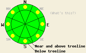
This morning, avalanche danger is LOW for all elevations and aspects. Pockets of MODERATE avalanche danger may form today on slopes steeper than 37 degrees below 8,000' due to daytime warming and possible rain on snow this afternoon. Small human triggered wet loose avalanches may become possible in some areas. |
|
|
|
The showers ended last night and the clouds departed leaving clear skies over the mountains after about 2 am. Skies should remain mostly clear through mid day today. The forecast calls for decreased winds and daytime highs in the mid 40's to low 50's between 7000 and 8000 ft and the upper 30's to upper 40's above 8000 ft. By this afternoon cloud cover should begin to rebuild over the area due to the low pressure approaching the region. As this low moves towards the forecast area over the next 36 hours, cloud cover and the chance of precipitation should increase. Initially the precipitation should remain light with little to no accumulation expected through tomorrow. Snow levels should remain above 8000 ft. through tomorrow. Precipitation should increase on Sat. night. For more information on this storm check in with the Reno NWS.
Yesterday, rainfall amounts exceeded expectations and some small loose wet snow instabilities consisting of roller balls and small point releases did occur late in the day on N aspects below 8000 ft. in the Echo summit area (photo, more info). Farther north on Donner Peak wet snow existed on all aspects up to 8000 ft. In both of these areas snow level was between 7200 and 8000 ft with rain falling on the snowpack below that level. Snowpit data on Donner Peak showed wet snow about 8-10 inches deep on northerly aspects and moist snow all the way to the ground on southerly aspects below 8000 ft (photo, snowpit, more info). Tests on these aspects indicated that propagating fractures remain unlikely. Ski cuts on steep, wet, N-facing test slopes on Donner Pass also did not produce any wet snow instabilities.
Avalanche Problem #1: Loose Wet Avalanches
A period of clear skis since 2am coupled with near freezing overnight temperatures should have allowed a thin refreeze to occur. This morning's sunshine and warmer temperatures will quickly melt this thin refreeze allowing wet snow to form on the sun-exposed E-SE-S-SW-W aspects. Increased cloud cover and some light rain showers this afternoon could help spread the wet snow to the northerly aspects later today. Some wet snow instabilities will become possible today as this increased melting allows thicker layers of wet snow to form. Since the snowpack has undergone several melt-freeze cycles, well established drainage channels exist through the snowpack in many places. These drainage channels help move free water through the snowpack and prevent it from weakening the snowpack as much as it does when the water pools in one layer. For this reason wet snow instabilities should remain limited to point releases, roller balls, and other surface instabilities.
This morning, avalanche danger is LOW for all elevations and aspects. Pockets of MODERATE avalanche danger may form today on slopes steeper than 37 degrees below 8,000' due to daytime warming and possible rain on snow this afternoon. Small human triggered wet loose avalanches may become possible in some areas.
| 0600 temperature: | 31-32 deg. F. |
| Max. temperature in the last 24 hours: | 34-38 deg. F. |
| Average wind direction during the last 24 hours: | Southwest |
| Average wind speed during the last 24 hours: | 15-25 mph |
| Maximum wind gust in the last 24 hours: | 46 mph |
| New snowfall in the last 24 hours: | Rain up to 8000 ft: .1-.3 inches | Above that snow: Trace to 2 inches |
| Total snow depth: | 47-83 inches |
For 7000-8000 ft: |
|||
| Friday: | Friday Night: | Saturday: | |
| Weather: | Mostly clear this morning becoming mostly cloudy with isolated rain showers by this afternoon | Mostly cloudy with isolated rain/snow showers. Snow level around 8000 ft. | Mostly cloudy with scattered rain showers. Some isolated thunderstorms possible in the afternoon. |
| Temperatures: | 46-52 deg. F. | 27-34 deg. F. | 43-50 deg. F. |
| Wind direction: | Variable | Variable | Variable |
| Wind speed: | Light | Light | Light |
| Expected snowfall: | O in. | O in. | O in. |
For 8000-9000 ft: |
|||
| Friday: | Friday Night: | Saturday: | |
| Weather: | Mostly clear this morning becoming mostly cloudy with isolated rain/snow showers by this afternoon. Snow level around 8500 ft. | Mostly cloudy with isolated rain/snow showers. Snow level around 8000 ft. | Mostly cloudy with scattered rain/snow showers. Some isolated thunderstorms possible in the afternoon. Snow level around 8000 ft. |
| Temperatures: | 37-47 deg. F. | 25-35 deg. F. | 34-44 deg. F. |
| Wind direction: | Southwest | Variable | South |
| Wind speed: | 10-15 mph | Light | 10-15 mph with gusts to 25 mph in the afternoon |
| Expected snowfall: | O in. | O in. | up to 1 in. |


This website is owned and maintained by the non-profit arm of the Sierra Avalanche Center. Some of the content is updated by the USDA avalanche forecasters including the forecasts and some observational data. The USDA is not responsible for any advertising, fund-raising events/information, or sponsorship information, or other content not related to the forecasts and the data pertaining to the forecasts.

