In partnership with: 
|
March 31, 2013 at 6:55 am |
|
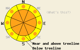
Near and above treeline, avalanche danger is CONSIDERABLE on all aspects on slopes 35 degrees and steeper. Below treeline, avalanche danger is MODERATE with pockets of CONSIDERABLE danger on all aspects on slopes 35 degrees and steeper. Natural and human triggered storm slab avalanches are possible today along with human triggered loose wet avalanches. |
|
|
|
A round of thunderstorms passed through the forecast area early this morning. Precipitation may taper off for a few hours this morning, before increasing again this afternoon as daytime warming drives atmospheric instability. Additional isolated thunderstorms are possible today, especially during the afternoon hours. Snow levels began around 8,500' to 9,000' in early precipitation prior to midnight last night. Early this morning as thunderstorms passed through the region, snow level lowered to 6,500' to 7,000'. Snow level is expected to remain around 7,000' today. Along the Sierra Crest, precipitation amounts of 4 to 8 inches of new snow have accumulated above 7,500' to 8,000' with 0.4 to 1 inch of rain elsewhere. Additional new snow amounts of 2 to 5 inches are expected today above 8,000'. Localized areas of greater snowfall amounts are possible under areas of thunderstorm activity. Remote sensors are reporting air temperatures this morning above 8,000' in the upper 20s to low 30s. Maximum daytime air temperatures above 7,000' are forecast to reach the upper 20s to upper 30s today. Ridgetop winds shifted from east to southwest yesterday. Light to moderate speed southwest winds are forecast for today.
Observations made yesterday on Powderhouse Peak (Luther Pass area) indicated that the snowpack was in good condition to handle new loading from rain and snow. Areas below 8,200' held significant amounts of wet snow top to bottom within the snowpack on all aspects during the afternoon hours. Free water drainage from the snowpack is well established in these areas from previous rain and melting events. This kept wet snow instability to a minimum. At 8,600', snowpit data collected on a N aspect revealed that the snowpack was close to transitioning to a fully isothermal snowpack. Of the 4 to 5 feet of snow on the ground around the snowpit, only to bottom 10 inches was not subject to free water percolation. No significant weak layers were observed.
Avalanche Problem #1: Storm Slabs
Ridgetop winds are at or below speeds required to create significant amounts of wind loading. New snow instability is expected to manifest as storm slabs today rather than wind slabs due to the expected lack of wind loading. Storm slabs that form today are expected up to 1 foot thick. Areas where thunderstorms occur could create pockets of locally higher snowfall amounts and thicker slabs. A very dynamic atmosphere is expected to deposit several different types of snow crystals including graupel into forming storm slabs. This may create significant weak layers within the storm slabs. Avalanche activity initiating within the new snow may step down to the old/new snow interface. Natural avalanches are possible today. Human triggered avalanches are likely.
Avalanche Problem #2: Loose Wet Avalanches
Rain on snow will keep concern for human triggered loose wet avalanches ongoing. Areas that receive rain on snow today already have free water drainage from the snowpack well established. Unsupportable wet snow existed in many yesterday below 8,200'. Many areas below 7,500' will not have refrozen last night and will likely remain unsupportable today.
Near and above treeline, avalanche danger is CONSIDERABLE on all aspects on slopes 35 degrees and steeper. Below treeline, avalanche danger is MODERATE with pockets of CONSIDERABLE danger on all aspects on slopes 35 degrees and steeper. Natural and human triggered storm slab avalanches are possible today along with human triggered loose wet avalanches.
| 0600 temperature: | 28 to 33 deg. F. |
| Max. temperature in the last 24 hours: | 48 to 52 deg. F. |
| Average wind direction during the last 24 hours: | Southwest |
| Average wind speed during the last 24 hours: | 22 mph |
| Maximum wind gust in the last 24 hours: | 53 mph |
| New snowfall in the last 24 hours: | 4 to 8 inches |
| Total snow depth: | 45 to 53 inches |
For 7000-8000 ft: |
|||
| Sunday: | Sunday Night: | Monday: | |
| Weather: | Cloudy skies with isolated thunderstorms and snow showers. | Cloudy skies with scattered snow showers. Isolated thunderstorms in the evening. | Mostly cloudy skies with scattered snow showers. |
| Temperatures: | 32 to 40 deg. F. | 27 to 35 deg. F. | 32 to 40 deg. F. |
| Wind direction: | SW | W | W |
| Wind speed: | Light winds increasing to 10 to 15 mph in the afternoon. | 10 to 15 mph in the evening, becoming light. | Light winds increasing to 10 to 15 mph in the afternoon. |
| Expected snowfall: | Local amounts higher, but generally up to 2 in. | Up to 1 in. | 0 to trace in. |
For 8000-9000 ft: |
|||
| Sunday: | Sunday Night: | Monday: | |
| Weather: | Cloudy skies with snow showers and isolated thunderstorms. | Cloudy skies with scattered snow showers. Isolated thunderstorms in the evening. | Mostly cloudy skies with scattered snow showers. |
| Temperatures: | 27 to 34 deg. F. | 20 to 30 deg. F. | 26 to 34 deg. F. |
| Wind direction: | SW | W | W |
| Wind speed: | 10 to 20 mph with gusts to 30 mph. | 10 to 15 mph with gusts up to 25 mph in the evening. | 10 to 15 mph with gusts up to 25 mph in the afternoon. |
| Expected snowfall: | Local amounts higher, but generally 2 to 5 in. | Up to 1 in. | Up to 1 in. |


This website is owned and maintained by the non-profit arm of the Sierra Avalanche Center. Some of the content is updated by the USDA avalanche forecasters including the forecasts and some observational data. The USDA is not responsible for any advertising, fund-raising events/information, or sponsorship information, or other content not related to the forecasts and the data pertaining to the forecasts.

