In partnership with: 
|
April 2, 2013 at 6:45 am |
|
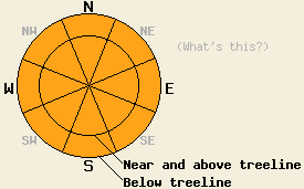
Both above and below treeline, CONSIDERABLE danger will form quickly today on all aspects and at all elevations on slopes 35 degrees and steeper due to loose wet snow avalanches. Shallow naturally occurring loose wet avalanches are expected. Human triggered loose wet avalanches of greater size are likely. |
|
|
|
High pressure will move into the forecast area for today and tomorrow. Partly cloudy skies, above freezing air temperatures, and light winds are forecast for both days. New snow amounts from the last storm measure 3 to 12 inches above 7,000' with the greatest accumulations along the Sierra Crest in the southern half of the forecast area. Remote sensors are reporting air temperatures above 8,000' this morning in the mid to upper 20s. Maximum daytime air temperatures are forecast to reach the low 40s to low 50s today for areas above 7,000'. Ridgetop winds are shifting from west to northeast this morning and are light in speed.
Yesterday, observations made or received from the Carson Pass, Luther Pass, Echo Summit, and Donner summit areas all indicated a lack of slab instability and increasing loose wet snow instability as the day progressed. On the south side of Carson Pass above Red Lake, ski cuts and formal snowpit data collected above 7,800' indicated that weak layers were absent from the 4 to 9 inches of storm snow in the area. Above 8,400', good bonding existed between the base of the storm snow and the melt-freeze crust below it. Ski cuts on 36 to 38 degree northerly aspect test slopes produced roller balls to 1+ foot in diameter from about 11am onwards. Around 7pm on Scout Peak (Echo Summit area), small and shallow human triggered loose wet snow avalanche activity and large roller balls were triggered on E aspect terrain between 8,000' and 8,200'. Wet marginally supportable to unsupportable snow below the storm snow layer was widespread and reported from many locations yesterday below 8,400'. (Click here for photos, pit profiles, and more info on these observations.)
Below freezing air temperatures last night are likely to have created areas of thin breakable crust at the snow surface on all aspects this morning.
Avalanche Problem #1: Loose Wet Avalanches
April sunshine providing significant incoming solar radiation today will combine with above freezing air temperatures to form widespread wet snow instability. Yesterday afternoon and evening provided a preview of what is expected to occur today on a larger scale both in size and distribution. Naturally occurring roller balls are expected to trigger shallow loose wet avalanches. Human triggers are likely to create sizeable loose wet avalanches, some of which could be long running. With unfrozen wet snow below the storm snow layer, loose wet avalanches that initiate within the recent storm snow may entrain wet snow deeper in the snowpack, below the storm snow/old snow interface. These deeper loose wet avalanches are most likely to occur below 8,400'. With high sun angles this time of year, northerly aspects will not be immune to wet snow instability today.
Avalanche Problem #2: Wet Slabs
Wet slab avalanche activity is unlikely and not expected to occur today due to a lack of propagating weak layers either within the recent storm snow, at the old/new snow interface, on within the old snow. Due to this lack of propagating weak layers, avalanche activity that occurs today is likely to manifest in the form of wet loose avalanches. That said, enough variability in storm snow amounts has occurred around the forecast area over the past few days that a very isolated single event type wet slab avalanche is not an impossibility today.
Both above and below treeline, CONSIDERABLE danger will form quickly today on all aspects and at all elevations on slopes 35 degrees and steeper due to loose wet snow avalanches. Shallow naturally occurring loose wet avalanches are expected. Human triggered loose wet avalanches of greater size are likely.
| 0600 temperature: | 24 to 29 deg. F. |
| Max. temperature in the last 24 hours: | 32 to 38 deg. F. |
| Average wind direction during the last 24 hours: | West |
| Average wind speed during the last 24 hours: | 26 mph |
| Maximum wind gust in the last 24 hours: | 42 mph |
| New snowfall in the last 24 hours: | Trace inches |
| Total snow depth: | 50 to 83 inches |
For 7000-8000 ft: |
|||
| Tuesday: | Tuesday Night: | Wednesday: | |
| Weather: | Partly cloudy skies. | Partly cloudy skies. | Partly cloudy skies. |
| Temperatures: | 44 to 52 deg. F. | 26 to 33 deg. F. | 50 to 57 deg. F. |
| Wind direction: | NE | Variable | Variable |
| Wind speed: | Light winds | Light winds | Light winds |
| Expected snowfall: | O in. | O in. | O in. |
For 8000-9000 ft: |
|||
| Tuesday: | Tuesday Night: | Wednesday: | |
| Weather: | Partly cloudy skies. | Partly cloudy skies. | Partly cloudy skies. |
| Temperatures: | 41 to 49 deg. F. | 27 to 33 deg. F. | 49 to 55 deg. F. |
| Wind direction: | NE | Variable | Variable |
| Wind speed: | 10 to 15 mph in the morning becoming light. | Light winds | Light winds |
| Expected snowfall: | O in. | O in. | O in. |


This website is owned and maintained by the non-profit arm of the Sierra Avalanche Center. Some of the content is updated by the USDA avalanche forecasters including the forecasts and some observational data. The USDA is not responsible for any advertising, fund-raising events/information, or sponsorship information, or other content not related to the forecasts and the data pertaining to the forecasts.

