In partnership with: 
|
April 3, 2013 at 7:00 am |
|
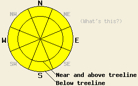
Both above and below treeline, MODERATE danger will form on all aspects and elevations on slopes 35 degrees and steeper due to daytime warming. Human triggered loose wet avalanches remain possible today. |
|
|
|
A high pressure ridge over the region should bring another mostly sunny warm day to the forecast area. The forecast calls for daytime highs in the upper 40's to upper 50's above 7000 ft. Currently warmer temperatures exist above 7000 ft due to cold air and some fog settling into the valleys last night. This inversion should lift this morning. A small wave of low pressure should begin to push some clouds into the region this afternoon. The southwest wind should also return and begin to increase. By tonight the area could see some light scattered precipitation. The clouds and precipitation should continue into tomorrow. The forecast calls for snow levels to stay near or above 8000 ft. with this small storm. Up to .3 of an inch of rain could fall below 8000 ft. and up to 3 inches of snow could accumulate above 8000 ft. during the day tomorrow.
Observations yesterday in the Donner Peak / Mt. Judah (photos, more info) area showed wet snow on all aspects. Ski cuts on steep E facing aspects near 8200 ft. triggered ski-width wet snow sluffs and large roller balls that gouged 2 ft deep trenches into the wet snow (photos). On the E-SE-S-SW aspects loose wet snow 1-3 ft deep existed by 2:30 pm. On the more northerly aspects 2-6 inches of wet snow existed on a frozen melt-freeze crust that could support a skier above 7800 ft. Below this elevation the melt-freeze crust became weaker and would sometimes break under the weight of a skier. Loose moist snow still remained under this crust.
Across the lake on Tamarack Peak (photos, video, more info) above 8800 ft, 2-3 inches of wet snow existed above a semi-frozen but still supportable melt-freeze crust on the E-SE-S-SW aspects by mid-day (video). Ski cuts on these slopes triggered widespread roller balls that involved the surface wet snow (photos). Below this crust a moist snowpack at least 2 ft deep existed. On the northerly aspects above 9000 ft. the 2-4 inches of surface snow remained cold and mostly dry through mid day.
Avalanche Problem #1: Loose Wet Avalanches
Even though clear skies and last night's near freezing temperatures should have allow a decent overnight refreeze to occur, today's strong sunshine and warm temperatures should melt through that refreeze by mid day. Human triggered wet loose avalanches consisting of point releases, large roller balls and pinwheels, and wet snow sluffs should continue today. Below 8500 ft. some of these could still become large and entrain some of the deeper wet snow that still exists below the surface. Since the sun has climbed higher into the sky at this time of year, wet snow instabilities could also exist on the northerly aspects.
Avalanche Problem #2: Wet Slabs
Wet slab avalanche activity remains unlikely today due to a lack weak layers within the snowpack and the fact that well established drainage channels exist to prevent water from pooling in the snowpack . Still, variability in storm snow amounts and deep wet snow mean that a very isolated wet slab avalanche is not impossible today.
Both above and below treeline, MODERATE danger will form on all aspects and elevations on slopes 35 degrees and steeper due to daytime warming. Human triggered loose wet avalanches remain possible today.
| 0600 temperature: | 30-38 deg. F. |
| Max. temperature in the last 24 hours: | 43-56 deg. F. |
| Average wind direction during the last 24 hours: | Variable |
| Average wind speed during the last 24 hours: | 5-10 mph |
| Maximum wind gust in the last 24 hours: | 25 mph |
| New snowfall in the last 24 hours: | O inches |
| Total snow depth: | 47-83 inches |
For 7000-8000 ft: |
|||
| Wednesday: | Wednesday Night: | Thursday: | |
| Weather: | Mostly clear becoming partly cloudy | Mostly cloudy with a slight chance of rain after midnight | Cloudy with rain showers |
| Temperatures: | 51-58 deg. F. | 33-40 deg. F. | 40-49 deg. F. |
| Wind direction: | Southwest | Southwest | Southwest |
| Wind speed: | Light increasing to 5-10 mph in the afternoon | 15-20 mph with gusts to 30 mph | 20-30 mph with gusts to 50 mph |
| Expected snowfall: | O in. | O in. | Rain up to .3 in. |
For 8000-9000 ft: |
|||
| Wednesday: | Wednesday Night: | Thursday: | |
| Weather: | Mostly clear becoming partly cloudy | Mostly cloudy with a slight chance of rain and snow showers after midnight. Snow level around 8000 ft. | Cloudy with rain and snow showers. Snow level between 8000 and 9000 ft. |
| Temperatures: | 45-51 deg. F. | 29-36 deg. F. | 30-40 deg. F. |
| Wind direction: | Southwest | Southwest | Southwest |
| Wind speed: | Light increasing to 10-15 mph with gusts to 25 mph in the afternoon | 10-15 mph with gusts to 25 mph increasing to 20-30 mph with gusts to 40 mph after midnight | 40-55 mph with gusts to 80 mph |
| Expected snowfall: | O in. | O in. | up to 3 in. |


This website is owned and maintained by the non-profit arm of the Sierra Avalanche Center. Some of the content is updated by the USDA avalanche forecasters including the forecasts and some observational data. The USDA is not responsible for any advertising, fund-raising events/information, or sponsorship information, or other content not related to the forecasts and the data pertaining to the forecasts.

