In partnership with: 
|
April 5, 2013 at 7:00 am |
|
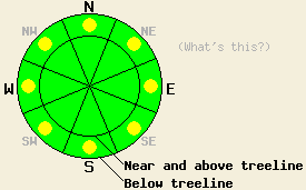
Below 8000 ft. pockets of MODERATE danger exist on all aspects on slopes 35 degrees and steeper. Human triggered loose wet avalanches remain possible today in some areas. |
|
|
|
During the last 24 hours, up to 3 inches of new snow fell above 8500 ft. Below this level .1-.4 inches of rain occurred. As this weak storm moved out of the area, temperatures, the southwest winds, and the cloud cover decreased. This morning expect partly cloudy skies with some breaks of sunshine and cooler temperatures. The forecast calls for daytime highs in the 30's above 8000 ft. and in the upper 30's to mid 40's between 7000 and 8000 ft today and tomorrow. As a stronger system pushes into the Pacific Northwest over the next few days, this area should see an increase in clouds and a chance for some scattered snow showers.
Yesterday wet snow several feet deep existed on all aspects on Andesite Ridge (photo, more info) due to rain falling on the snowpack. In some areas on the northerly aspects a supportable semi-frozen crust existed near the surface and in others it did not. Ski cuts on slopes where this crust remained supportable produced small surface wet snow instabilities. In other areas on the E-SE-S aspects where the crust did not exist a person could sink 2 ft deep into wet snow if he/she stepped off of his/her skis. Snow level in this area yesterady remained above 8300 ft.
Avalanche Problem #1: Loose Wet Avalanches
Colder temperatures and the end of the rain showers should have allowed the snowpack to begin refreezing. This process will take time due to the amount of wet snow present in the snowpack. Well established drainage channels that prevent water from pooling in the snowpack, cooler daytime highs, increasing cloud cover, and the afore meniton slow refreezing process should all work to limit the wet snow instabilities today. Since some of the areas below 8000 ft. did not experience as much of a refreeze some human triggered wet loose avalanches consisting of point releases, roller balls and pinwheels, and wet snow sluffs may continue today. Some of these could still become large and entrain some of the deeper wet snow that still exists below the surface.
Below 8000 ft. pockets of MODERATE danger exist on all aspects on slopes 35 degrees and steeper. Human triggered loose wet avalanches remain possible today in some areas.
| 0600 temperature: | 22-30 deg. F. |
| Max. temperature in the last 24 hours: | 31-40 deg. F. |
| Average wind direction during the last 24 hours: | Southwest |
| Average wind speed during the last 24 hours: | 30-35 mph |
| Maximum wind gust in the last 24 hours: | 83 mph |
| New snowfall in the last 24 hours: | Below 8500 ft - rain: .1-.4 in. | Above 8500 ft - snow: 1-3 inches |
| Total snow depth: | 46-83 inches |
For 7000-8000 ft: |
|||
| Friday: | Friday Night: | Saturday: | |
| Weather: | Partly sunny this morning becoming mostly cloudy by this afternoon | Cloudy with isolated snow showers | Mostly cloudy with isolated snow showers |
| Temperatures: | 39-48 deg. F. | 26-31 deg. F. | 38-46 deg. F. |
| Wind direction: | Southwest | Southwest | Southwest |
| Wind speed: | 15-20 mph with gusts to 35 mph | 15-20 mph with gusts to 30 mph | 15-20 mph with gusts to 35 mph |
| Expected snowfall: | O in. | O in. | O in. |
For 8000-9000 ft: |
|||
| Friday: | Friday Night: | Saturday: | |
| Weather: | Partly sunny this morning becoming mostly cloudy by this afternoon | Cloudy with isolated snow showers | Mostly cloudy with isolated snow showers |
| Temperatures: | 33-39 deg. F. | 22-27 deg. F. | 32-38 deg. F. |
| Wind direction: | Southwest | Southwest | Southwest |
| Wind speed: | 20-30 mph with gusts to 45 mph | 20-30 mph with gusts to 45 mph | 20-30 mph with gusts to 45 mph |
| Expected snowfall: | O in. | O in. | O in. |


This website is owned and maintained by the non-profit arm of the Sierra Avalanche Center. Some of the content is updated by the USDA avalanche forecasters including the forecasts and some observational data. The USDA is not responsible for any advertising, fund-raising events/information, or sponsorship information, or other content not related to the forecasts and the data pertaining to the forecasts.

