THIS AVALANCHE FORECAST EXPIRED ON January 3, 2015 @ 6:50 am
Avalanche Forecast published on January 2, 2015 @ 6:50 am
Issued by Brandon Schwartz - Tahoe National Forest

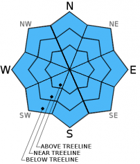
Avalanche danger is LOW for all elevations and aspects.

Normal caution is advised.

1. Low

?

Above Treeline
Generally safe avalanche conditions. Watch for unstable snow on isolated terrain features.

1. Low

?

Near Treeline
Generally safe avalanche conditions. Watch for unstable snow on isolated terrain features.

1. Low

?

Below Treeline
Generally safe avalanche conditions. Watch for unstable snow on isolated terrain features.
    Generally safe avalanche conditions. Watch for unstable snow on isolated terrain features.
Avalanche Problem 1: Normal Caution
  • Type ?
  • Aspect/Elevation ?
  • Likelihood ?
    Certain
    Very Likely
    Likely
    Possible
    Unlikely
  • Size ?
    Historic
    Very Large
    Large
    Small

Wind slabs that formed on a variety of aspects near and above treeline earlier this week have had some time to gain strength. Triggering an avalanche is currently unlikely, but not impossible. Areas of complex or extreme terrain where slab thickness varies greatly represent the areas where triggering a lingering unstable wind slab remains most likely. Examples of such terrain include couloirs, gullies, cliffbands, and unsupported slopes. Evidence of instability will likely be challenging to find in the backcountry today. Continue to employ accepted best practice travel techniques to limit individual exposure to avalanche terrain.

recent observations

Recent observations from around the forecast area revealed areas of blowing snow Dec 30-31. Significant amounts of wind transport were noted, but associated wind slab formation was not particularly large. Above treeline terrain holds well defined areas of NE wind deposited snow and NE wind scoured rain crust. Near treeline areas hold a mix of scouring and deposit that can be found on all aspects. In wind protected areas below treeline, a few inches of unconsolidated recent storm snow remain at the snow surface. A developing layer of near crust facets that exists below and in some cases above the uppermost rain crust in the snowpack remains worth monitoring for future instability concerns.

Weather and CURRENT CONDITIONS
weather summary

Building high pressure over the region will allow for sunny skies, lights winds, and continued warming. An air temperature inversion has set up allowing for air temperatures this morning in the mid to upper 20s on the peaks and in the low to mid teens on the mountain valley floors. Maximum daytime air temperatures are forecast to warm into the low to upper 30s today for most locations. Relatively light winds over the weekend will allow this condition to persist. Ridgetop winds have finally subsided to light to moderate in speed following the recent gale force NE wind event. Ridgetop winds are forecast to shift from NE to NW today and remain light in speed.

CONDITIONS ALONG THE SIERRA CREST BETWEEN 8200 FT. AND 9200 FT. IN THE LAST 24 HOURS
6am temperature: 25 to 30 deg. F.
Max. temperature: 33 to 37 deg. F.
Average ridgetop wind direction: East
Average ridgetop wind speed: 25 mph
Maximum ridgetop wind gust: 42 mph
New snowfall: 0 inches
Total snow depth: 27 to 40 inches
Two-Day Mountain Weather Forecast Produced in partnership with the Reno NWS
For 7000 ft. to 8000 ft.
Friday Friday Night Saturday
Weather: Sunny skies. Clear skies. Sunny skies.
Temperatures: 31 to 38 deg. F. 17 to 25 deg. F. 34 to 41 deg. F.
Mid Slope Winds: NW NE NE
Wind Speed: Light winds becoming 10 to 15 mph in the afternoon. 10 to 15 mph. 10 to 15 mph in the morning, becoming light.
Expected snowfall: 0 0 0
For 8000 ft. to 9000 ft.
Friday Friday Night Saturday
Weather: Sunny skies. Clear skies. Sunny skies.
Temperatures: 29 to 36 deg. F. 23 to 29 deg. F. 31 to 38 deg. F.
Ridge Top Winds: NW NE NE
Wind Speed: 10 to 15 mph. 10 to 15 mph with gusts to 25 mph. 10 to 15 mph. Gusts up to 25 mph in the morning.
Expected snowfall: 0 0 0
Disclaimer

This avalanche advisory is provided through a partnership between the Tahoe National Forest and the Sierra Avalanche Center. This advisory covers the Central Sierra Nevada Mountains between Yuba Pass on the north and Ebbetts Pass on the south. Click here for a map of the forecast area. This advisory applies only to backcountry areas outside established ski area boundaries. This advisory describes general avalanche conditions and local variations always occur. This advisory expires 24 hours after the posted time unless otherwise noted. The information in this advisory is provided by the USDA Forest Service who is solely responsible for its content.