THIS AVALANCHE FORECAST EXPIRED ON December 19, 2016 @ 7:03 am
Avalanche Forecast published on December 18, 2016 @ 7:03 am
Issued by Andy Anderson - Tahoe National Forest - Sierra Avalanche Center

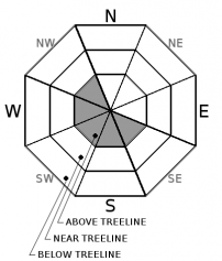
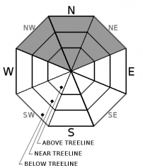
MODERATE avalanche danger may exist on NW-W-SW-S-SE aspects in above treeline terrain due to possible wind slabs created by forecasted NE and E winds. These new wind slabs should remain small but could knock a person off their feet. Triggering a deep slab avalanche on NW-N-NE aspects above 9000 ft. has become unlikely but not impossible. At elevations below 9000 ft. less avalanche danger exists, but firm icy slopes with a dusting of snow may exist on all aspects.

2. Moderate

?

Above Treeline
Heightened avalanche conditions on specific terrain features. Evaluate snow and terrain carefully; identify features of concern.

1. Low

?

Near Treeline
Generally safe avalanche conditions. Watch for unstable snow on isolated terrain features.

1. Low

?

Below Treeline
Generally safe avalanche conditions. Watch for unstable snow on isolated terrain features.
    Heightened avalanche conditions on specific terrain features. Evaluate snow and terrain carefully; identify features of concern.
Avalanche Problem 1: Wind Slab
  • Type ?
  • Aspect/Elevation ?
  • Likelihood ?
    Certain
    Very Likely
    Likely
    Possible
    Unlikely
  • Size ?
    Historic
    Very Large
    Large
    Small

Light to moderate east and northeast winds may continue to transport small amounts of snow today. This wind loading may create very small wind slabs on some of the NW-W-SW-S-SE aspects in above treeline terrain. These small isolated wind slabs should not extend very far down-slope and should be limited to upper elevation areas with available snow where the wind may be strong enough to transport snow. While some of these may be sensitive to human triggering today they should remain too small to pose much threat to backcountry travelers except in areas where a stumble or getting knocked off balance could have consequences. Triggering the older larger wind slabs that formed during the 12/15 storm wind-loaded on N-NE-E aspects and cross-loaded NW and SE aspects has become unlikely. The cornices that exist above many of these wind loaded slopes may still remain fragile today and could still break well away from their edges.

Avalanche Problem 2: Deep Slab
  • Type ?
  • Aspect/Elevation ?
  • Likelihood ?
    Certain
    Very Likely
    Likely
    Possible
    Unlikely
  • Size ?
    Historic
    Very Large
    Large
    Small

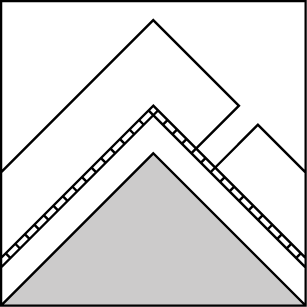
Triggering a deep slab avalanche has become unlikely due to the strength of the snow above the deeply buried persistent weak layers that still exist on NW-N-NE aspects above 9000 ft. However, in the unlikely event that this layer does break, fractures can still travel along the layer and the resulting avalanche would be large, destructive, and likely unsurvivable. While triggering these deeps slabs has become unlikely, it is not impossible for some very large trigger or a trigger on just the right trigger point to break the PWL and release a deep slab on some isolated terrain. 

Due to the consequences associated with the large destructive avalanches that could occur if the persistent weak layer fails and the high degree of uncertainty associated with it, this unlikely but not impossible avalanche problem still warrants extra caution. 

recent observations

Yesterday observations from Donner Summit, Carson Pass, and the Mt. Rose backcountry all showed some amount of cold unconsolidated snow sitting on top of the 12/15 rain crust in the upper snowpack in sheltered areas. At the higher elevations in the Mt. Rose area 10 to 18 inches of this colder snow existed while only about 4 to 6 inches existed along the Sierra Crest. In all these areas, the top 4 to 12 inches of the snowpack showed signs of becoming looser and weaker (facetting). Snowpit data from Meiss Headwaters on at 8700 ft. and snowpit data from Andesite Peak at 7400 ft. on E aspects both showed some weakness forming around the 12/15 rain crust buried about 4 to 6 inches below the surface. These weaknesses do not have much snow above them at the moment but will need monitoring to determine how they develop and how they could respond to future loading. Below this soft snow and the 12/15 rain crust a slowly refreezing snowpack existed along the Sierra Crest below 9000 ft.  

In the Mt. Rose backcountry above 9000 ft, a much deeper and colder snowpack exists. Recent snowpit data from the Mt. Rose backcountry including snowpit data from Tamarack Peak and Incline Lake Peak yesterday showed good bonding and consolidation in the upper snowpack, but observations also still show a slowly consolidating layer of weak snow near the base of the snowpack on northerly aspects in the Mt. Rose backcountry. This persistent weak layer exists between 120 and 160 cm below the surface and below all the strong snow. Tests targeting this layer indicated that actually getting enough force through the snowpack to break this layer has become unlikely without a very large trigger or some exceptional circumstances. However, tests also indicated that if the layer does break, fractures could still travel along this persistent weak layer.  

In addition to the snowpack data from yesterday, two small avalanches were reported, one observed on the E face of Mt. Judah and one on the NE face of Incline Lake Peak. Both of these were observed from a distance and likely occurred on 12/16 based on some snow covering up the crowns. In more exposed above treeline areas at Carson Pass and on Tamarack Peak scoured icy surfaces existed on windward aspects

Weather and CURRENT CONDITIONS
weather summary

Another cold, clear, and mostly calm night has left temperatures in the valleys colder than those at upper elevations with sensors reporting lows in the low single digits in the valleys and 8 to 14 degrees F. between 8200 and 8800 ft. This inversion should persist longer than normal today due to light winds and low sun angles. Above 7000 ft. the forecast calls for daytime highs to climb into the upper 20's today and mid to upper 30's tomorrow. A high-pressure ridge over the area should keep the weather sunny and dry. The forecast also calls fo light to moderate east winds especially at the upper elevations today and tomorrow. 

CONDITIONS ALONG THE SIERRA CREST BETWEEN 8200 FT. AND 9200 FT. IN THE LAST 24 HOURS
6am temperature: 8 to 14 deg. F.
Max. temperature: 20 to 32 deg. F.
Average ridgetop wind direction: Southwest shifting to east and northeast
Average ridgetop wind speed: 10 to 20 mph
Maximum ridgetop wind gust: 43 mph
New snowfall: 0 inches
Total snow depth: Along the Sierra Crest: 17 to 34 inches | In the Mt. Rose area: 56 inches
Two-Day Mountain Weather Forecast Produced in partnership with the Reno NWS
For 7000 ft. to 8000 ft.
Sunday Sunday Night Monday
Weather: Sunny Clear Sunny becoming partly cloudy in the afternoon
Temperatures: 25 to 30 deg. F. 12 to 20 deg. F. 36 to 41 deg. F.
Mid Slope Winds: Variable Variable Variable
Wind Speed: Light with some gusts up to 25 mph in the afternoon Light Light
Expected snowfall: 0 0 0
For 8000 ft. to 9000 ft.
Sunday Sunday Night Monday
Weather: Sunny Clear Sunny becoming partly cloudy in the afternoon
Temperatures: 25 to 30 deg. F. 19 to 25 deg. F. 34 to 39 deg. F.
Ridge Top Winds: East East Variable
Wind Speed: 15 to 25 mph with gusts to 35 mph increasing to gusts to 45 mph in the afternoon 10 to 15 mph with gusts to 35 mph Light with gusts up to 25 mph
Expected snowfall: 0 0 0
Disclaimer

This avalanche advisory is provided through a partnership between the Tahoe National Forest and the Sierra Avalanche Center. This advisory covers the Central Sierra Nevada Mountains between Yuba Pass on the north and Ebbetts Pass on the south. Click here for a map of the forecast area. This advisory applies only to backcountry areas outside established ski area boundaries. This advisory describes general avalanche conditions and local variations always occur. This advisory expires 24 hours after the posted time unless otherwise noted. The information in this advisory is provided by the USDA Forest Service who is solely responsible for its content.

For a recorded version of the Avalanche Advisory call (530) 587-3558 x258