THIS AVALANCHE FORECAST EXPIRED ON April 7, 2017 @ 6:45 am
Avalanche Forecast published on April 6, 2017 @ 6:45 am
Issued by Andy Anderson - Tahoe National Forest - Sierra Avalanche Center

LOW avalanche danger this morning will increase to MODERATE as loose wet avalanches become possible due to a weak refreeze, warm temperatures, and possible rain today. 

During the night natural avalanches will become possible and the avalanche danger will rise to CONSIDERABLE as a strong storm arrives over the region. WIND SLABS, STORM SLABS, and LOOSE WET avalanche problems could become widespread. Expect dangerous avalanche conditions in the backcountry through Saturday. Check back tomorrow morning for the latest updates. 

2. Moderate

?

Above Treeline
Heightened avalanche conditions on specific terrain features. Evaluate snow and terrain carefully; identify features of concern.

2. Moderate

?

Near Treeline
Heightened avalanche conditions on specific terrain features. Evaluate snow and terrain carefully; identify features of concern.

2. Moderate

?

Below Treeline
Heightened avalanche conditions on specific terrain features. Evaluate snow and terrain carefully; identify features of concern.
    Heightened avalanche conditions on specific terrain features. Evaluate snow and terrain carefully; identify features of concern.
Avalanche Problem 1: Loose Wet
  • Type ?
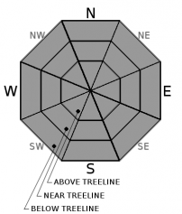
  • Aspect/Elevation ?
  • Likelihood ?
    Certain
    Very Likely
    Likely
    Possible
    Unlikely
  • Size ?
    Historic
    Very Large
    Large
    Small

Warm temperatures and cloudy skies last night mean that little to no refreeze may have occurred in some areas. Today's possible light rain and warm temperatures could provide the warming needed to melt through the weak refreeze and allow loose wet avalanches to become possible again. If temperatures and snow levels fall faster than predicted, loose wet avalanches will remain unlikely today. 

Forecast discussion

The avalanche danger will increase quickly and dramatically as a strong atmospheric river-type storm arrives over the forecast area starting tonight. Expect wind slabs, storm slabs, and loose wet avalanche problems to become widespread in response to accumulating snow, intense snowfall rates, strong winds, and heavy rain. Human triggered avalanches will become likely tonight and some natural avalanches will be possible. If the storm arrives sooner than expected, these avalanche problems will also form sooner. If for some reason backcountry travel is required tonight, dangerous avalanche conditions will exist. Expect dangerous avalanche conditions in the backcountry tomorrow and Satuday as the storm continues.

recent observations

Yesterday areas of wet unsupportable snow existed as early as 10 am in some places below 7500 ft. on Jakes Peak and before 9 am in some areas on Maggies Peak. Above 7500 ft. in both these areas, the snowpack remained mostly supportable until around noon when the weak overnight refreeze completely melted leaving behind deep, wet, unsupportable snow. Glide cracks existed in some areas on S. Maggies Peak. Overall data and observations indicate that the snowpack should remain supportable and consolidated once it refreezes below the forecasted new snow. 

Weather and CURRENT CONDITIONS
weather summary

Clouds and winds will increase today ahead of a strong atmospheric river projected to hit the region starting tonight. Warm air ahead of this system should keep temperatures in the mid to upper 40's today and snow levels should remain in the 7500 to 8500 ft. range for today. A slight (25%) chance of some light precipitation exists during the day today and could fall as rain or light snow depending on elevation and where the snow level is. The main storm will arrive tonight and continue through Saturday with gale force southwest winds and intense precipitation. Sustained ridgetop winds in the 50 to 70 mph range are likely throughout this storm and gusts could climb to 120 mph. Tonight snow levels should begin to fall and could be anywhere between 6000 ft. and 8000 ft. By tomorrow they should drop to between 6000 and 7000 ft. for much of the day. Due to the uncertainty associated with the snow levels, uncertainty exists concerning whether rain or snow will fall below 8000 ft. tonight. If snow levels are lower, then all areas above 7000 ft. could get mostly snow and receive 8 to 15 inches of new snow tonight. With higher snow levels much of this precipitation would fall as rain below 8000 ft. The forecast calls for precipitation rates to intensify tomorrow with another 5 to 15 inches of snow depending on elevation and actual snow levels. By the end of the storm late Saturday, an additional 2 to 5 inches of water could accumulate along the Sierra Crest in the form of 2 to 4 ft. of heavy snow or rain which one again depends on elevation and actual snow levels. For more details and the most up to date information on this storm check in with the Reno NWS.

CONDITIONS ALONG THE SIERRA CREST BETWEEN 8200 FT. AND 9200 FT. IN THE LAST 24 HOURS
6am temperature: 33 to 41 deg. F.
Max. temperature: 46 to 55 deg. F.
Average ridgetop wind direction: Southwest
Average ridgetop wind speed: 35 to 50 mph
Maximum ridgetop wind gust: 109 mph
New snowfall: 0 inches
Total snow depth: 112 to 170 inches
Two-Day Mountain Weather Forecast Produced in partnership with the Reno NWS
For 7000 ft. to 8000 ft.
Thursday Thursday Night Friday
Weather: Mostly cloudy with clouds increasing during the day. Slight chance of rain and snow showers with snow levels between 7500 and 8500 ft. Cloudy with rain and snow. Snow levels between 6000 and 8000 ft. Cloudy with snow and rain. Snow levels between 6000 and 7000 ft.
Temperatures: 44 to 49 deg. F. 34 to 39 deg. F. 31 to 36 deg. F.
Mid Slope Winds: Southwest Southwest Southwest
Wind Speed: 15 to 25 mph increasing to 20 to 30 mph in the afternoon with gusts to 50 mph 25 to 35 mph with gusts to 70 mph 25 to 35 mph with gusts to 75 mph
Expected snowfall: 0 in. with a slight chance of up to 1 Depending on snow level : up to 10 in. with a possibility of 8 to 15 Depending on snow levels 5 to 15
For 8000 ft. to 9000 ft.
Thursday Thursday Night Friday
Weather: Mostly cloudy with clouds increasing during the day. Slight chance of rain and snow showers with snow levels between 7500 and 8500 ft. Snow Snow
Temperatures: 39 to 47 deg. F. 29 to 35 deg. F. 30 to 36 deg. F.
Ridge Top Winds: Southwest Southwest shifting to the south after midnight Southwest
Wind Speed: 35 to 60 mph with gusts to 110 mph 35 to 60 mph increasing to 45 to 65 mph after midnight. Gusts to 120 mph. 50 to 70 mph with gusts to 120 mph
Expected snowfall: 0 in. with a slight chance of 1 to 2 7 to 15 8 to 15
Disclaimer

This avalanche advisory is provided through a partnership between the Tahoe National Forest and the Sierra Avalanche Center. This advisory covers the Central Sierra Nevada Mountains between Yuba Pass on the north and Ebbetts Pass on the south. Click here for a map of the forecast area. This advisory applies only to backcountry areas outside established ski area boundaries. This advisory describes general avalanche conditions and local variations always occur. This advisory expires 24 hours after the posted time unless otherwise noted. The information in this advisory is provided by the USDA Forest Service who is solely responsible for its content.

For a recorded version of the Avalanche Advisory call (530) 587-3558 x258