Avalanche Forecast published on November 18, 2017 @ 6:28 am
Issued by Brandon Schwartz - Tahoe National Forest

Early season conditions update #5

Normal caution, focusing on best travel practices in or near avalanche terrain is appropriate for most of the forecast area. Ongoing concern for deep slab avalanches in the Mount Rose portion of the forecast area is decreasing, but not entirely gone. Large destructive avalanches are unlikely but not impossible in isolated areas. Uncertainly remains for terrain that matches the location of the deep slab avalanche problem. Do not underestimate potential avalanche size or consequences.

No Rating

?

Above Treeline

No Rating

?

Near Treeline

No Rating

?

Below Treeline
Avalanche Problem 1: Normal Caution
  • Type ?

For portions of the forecast area along the Sierra Crest, a usable snowpack exists above 8,000' with a marginally usable snowpack between 7,000' and 8,000'. The snowpack above 8,000' is generally 3+ feet deep and supportable. Little to no snow exists below 7,000'. Most of the terrain along the Sierra Crest below 9,000' received significant rain during the last storm.

Most Sierra Crest areas have either exposed rain crust (firm ice) on the snow surface or a few inches of recent storm snow on top of a rain crust. A potentially problematic graupel layer has been seen on top of the rain crust, just below the few inches of recent storm snow in some areas. This layer could contribute to small human triggered avalanches over the next few days.

Above freezing air temperatures are expected this weekend. Some surface wet snow may form on southerly aspects, but wet snow avalanche problems are not expected.


Avalanche Problem 2: Deep Slab
  • Type ?
  • Aspect/Elevation ?
  • Likelihood ?
    Certain
    Very Likely
    Likely
    Possible
    Unlikely
  • Size ?
    Historic
    Very Large
    Large
    Small

This problem is specific to the Mount Rose portion of the forecast area. Despite signs of improving stability, the deep slab avalanche problem is well understood to have a higher level of uncertainly than other avalanche problems. Additionally, the snowpack does not gain stability at an equal rate in all locations. This leaves some uncertainly as to the ongoing possibility of an isolated deep slab avalanche event in the coming days. While it has become unlikely, it is not impossible.

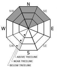
NW-N-NE aspects above 8,500' to 9,000' warrant a conservative approach with thorough planning and evidence gathering. Snowpack failure would occur within faceted old snow near the ground, below the 3 feet of recent storm snow. Committing to a line with little evidence to back the decision is simply guessing. This is not a good tactic in backcountry avalanche terrain. There are plenty of smarter terrain choices. Do not allow the absence of signs of instability to lull your group into marginal or sloppy travel techniques in avalanche terrain. A single, isolated (no one in the group thought it would really happen type of) avalanche event could have disastrous consequences.

recent observations

-Natural and human triggered deep slab avalanches occurred on N and NE aspects in the Mount Rose portion of the forecast area on Nov 16.

-SAC forecasters and public parties found diminishing signs of deep slab instability in the Mount Rose portion of the forecast area on Nov 17. (Do not interpret this as the definitive end of the deep slab avalanche problem.)

-SAC pro observer and public parties observed rain wetted snow, rain crusts, and some recent storm snow on the surface along the Sierra Crest in the Carson Pass and Donner Summit areas. Some potential for shallow instability in places where a graupel layer exists between the top of the upper most rain crust in the snowpack and recent storm snow on the surface.

See specific observations below for more info.


Weather and CURRENT CONDITIONS
weather summary

Sunny skies on Saturday. Increasing high level clouds on Sunday. Next precipitation event expected on Monday.

Two-Day Mountain Weather Forecast Produced in partnership with the Reno NWS
For 7000 ft. to 8000 ft.
Saturday Saturday Night Sunday
Weather: Sunny skies. Partly cloudy skies. Sunny skies with increasing high level cloud cover.
Temperatures: 40 to 45 deg. F. 25 to 30 deg. F. 43 to 48 deg. F.
Mid Slope Winds: SW SW SW
Wind Speed: Light winds Light winds Light winds increasing to 10 to 15 mph.
Expected snowfall: 0 0 0
For 8000 ft. to 9000 ft.
Saturday Saturday Night Sunday
Weather: Sunny skies. Partly cloudy skies Sunny skies with increasing high level cloud cover.
Temperatures: 36 to 42 deg. F. 26 to 31 deg. F. 40 to 45 deg. F.
Ridge Top Winds: SW SW SW
Wind Speed: 10 to 15 mph with gusts to 30 mph. 15 to 20 mph with gusts to 35 mph. 15 to 20 mph with gusts to 40 mph.
Expected snowfall: 0 0 0
Disclaimer

This avalanche advisory is provided through a partnership between the Tahoe National Forest and the Sierra Avalanche Center. This advisory covers the Central Sierra Nevada Mountains between Yuba Pass on the north and Ebbetts Pass on the south. Click here for a map of the forecast area. This advisory applies only to backcountry areas outside established ski area boundaries. This advisory describes general avalanche conditions and local variations always occur. This advisory expires 24 hours after the posted time unless otherwise noted. The information in this advisory is provided by the USDA Forest Service who is solely responsible for its content.

For a recorded version of the Avalanche Advisory call (530) 587-3558 x258