Avalanche Forecast published on November 20, 2017 @ 6:50 am
Issued by Steve Reynaud - Tahoe National Forest

Early season conditions update #6

Normal caution is advised throughout the forecast area with useable snow above 8000'.  The potential exists for minor loose wet snow avalanches at all elevations today with the forecasted rain and above freezing temperatures.   The ongoing deep slab avalanche problem in the Mt. Rose area continues to decrease, although some uncertainty continues for high elevation terrain.  Practice safe travel protocols when in or near avalanche terrain.

No Rating

?

Above Treeline

No Rating

?

Near Treeline

No Rating

?

Below Treeline
Avalanche Problem 1: Normal Caution
  • Type ?

For areas in the forecast area along the Sierra Crest, a supportable snowpack of 2' deep exists above 8000'.  Above 8500', the snowpack increases to 3'+ deep.  In the Mt. Rose area, above 8500' also has a 3'+ snowpack.  Below 7200'-7800' throughout the forecast area, the snowpack is shallow with a minimal amount of useable snow.  Many hazards and obstacles exist throughout the region including: exposed trees, rocks, bushes, open water, creek crossings, etc.  Firm rain crusts exist in wind scoured terrain throughout the area and could pose travel hazards.  

Above freezing air temperatures are expected through this week with the chance of light rain up to 10,000' today.  Surface wet snow may form on all aspects and elevations with the possibility of small roller balls depending on rain amounts received.

Avalanche Problem 2: Deep Slab
  • Type ?
  • Aspect/Elevation ?
  • Likelihood ?
    Certain
    Very Likely
    Likely
    Possible
    Unlikely
  • Size ?
    Historic
    Very Large
    Large
    Small

The ongoing deep slab avalanche problem continues to be unlikely but not impossible.  This problem is specific to the Mt. Rose area above 8500' on NW-N-NE aspects.  This is a low probability but high consequence event.  Most recent observations have shown that the previous weak basal facets have been gaining strength, beginning to round, are moist, and have become non reactive to most snowpack tests.  Although an observation from Saturday at 10,000' on a NE aspect, had ECT results that showed propagation was likely on the loose basal faceted layer

The deep slab avalanche problem has a higher level of uncertainty than other avalanche problems.  Our typical snowpack tests and informal observations are not as reliable with a deep slab avalanche problem as with other avalanche problems.  Conservative route finding and decision making along with standard bc travel protocols are best practice.    

recent observations

-Several ECTP's on Mt. Houghton in the Mt. Rose area at 10,000' on the basal facet layer.

-SAC forecaster observations of the basal facet layer in the Mt. Rose area gaining strength.

-Graupel layer and near surface facets observed along the Sierra Crest at Carson Pass and the West Shore.

See specific observations below for more info.

Weather and CURRENT CONDITIONS
weather summary

A weak and warm system will bring a chance of light rain and high elevation snow to the northern part of the forecast area today.  Snow levels are forecasted to rise up to 10,000 this afternoon.  SW winds will increase throughout the region.  Drier weather with above freezing temperatures are expected Tuesday through the rest of the week.

Two-Day Mountain Weather Forecast Produced in partnership with the Reno NWS
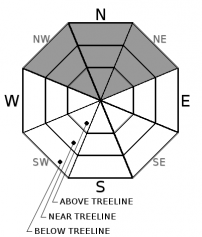
For 7000 ft. to 8000 ft.
Monday Monday Night Tuesday
Weather: Cloudy. Chance of snow and rain in the morning then chance of rain. Mostly cloudy. Slight chance of rain in the evening. Mostly cloudy.
Temperatures: 44 to 49 deg. F. 35 to 40 deg. F. 52 to 58 deg. F.
Mid Slope Winds: SW SW SW
Wind Speed: 10 to 20mph. Gusts up to 30mph. 10 to 15mph with gusts to 35mph decreasing to 10mph. 5 to 15mph. Gusts up to 25mph in the morning.
Expected snowfall: 0 0 0
For 8000 ft. to 9000 ft.
Monday Monday Night Tuesday
Weather: Cloudy. Chance of light rain and snow. Mostly cloudy. Slight chance of rain in the evening. Mostly cloudy.
Temperatures: 39 to 45 deg. F. 34 to 39 deg. F. 49 to 55 deg. F.
Ridge Top Winds: SW SW SW
Wind Speed: 25 to 40mph with gusts to 65mph, decreasing to 20 to 30mph with gusts to 55mph in the afternoon. 20 to 30mph with gusts to 45mph decreasing to 15 to 20 with gusts to 35mph after midnight. 15 to 25mph with gusts to 50mph.
Expected snowfall: Up to 1 0 0
Disclaimer

This avalanche advisory is provided through a partnership between the Tahoe National Forest and the Sierra Avalanche Center. This advisory covers the Central Sierra Nevada Mountains between Yuba Pass on the north and Ebbetts Pass on the south. Click here for a map of the forecast area. This advisory applies only to backcountry areas outside established ski area boundaries. This advisory describes general avalanche conditions and local variations always occur. This advisory expires 24 hours after the posted time unless otherwise noted. The information in this advisory is provided by the USDA Forest Service who is solely responsible for its content.

For a recorded version of the Avalanche Advisory call (530) 587-3558 x258